| Home | Open Account | Help | 386 users online |
|
Member Login
Discussion
Media SharingHostingLibrarySite Info |
Western Railroad Discussion > Re: Pasadena, CA And The Ex ATSF Second DistrictDate: 12/29/07 15:25 Re: Pasadena, CA And The Ex ATSF Second District Author: Des-Lab Not sure if this message is more appropriate in the Nostalgia section or here. So I tossed a coin and decided to post here.
Anyway, I have a few questions regarding the ex ATSF Second District that maybe some of you who got to see it can answer. My travels today took me up through that area and I stopped for a few minutes. Unfortunately, I found only the slightest traces of the old Second District in Pasadena. First: The old passenger depot. In driving along the tracks (Arroyo Pkwy follows the ROW to the east and Raymond on the west side), there is no way to tell exactly where the old depot was. But I remember reading here that it was at the corner of Del Mar and Raymond. So I stopped there. The location makes sense since the entire NE corner is built up with what looks like high rise condos or apartments. Also, if you look at some old pictures of the depot, you can see in many of them, in the background, what looks to be a house on a hill with a few rotundas or gazebos being the main defining features. I had to look hard, but it is still there. So I knew for sure that I was at the right spot. Anyway, the depot is not really visible from the street. At least not the view that was seen track side and that appears in some old pictures posted here. But if you walk into that 'complex', then the depot becomes more visible. It appears to have been converted into a restaurant. But the entire lot around it has been built up. My questions are this. First, is it in the same physical location as it was in the ATSF days or has it been moved? Second, are the tracks on the same alignment? Again, I've only seen a handful of old pictures of that location and never in person. So it's impossible to gauge the scale of the area. Also, directly across the street from the site of the depot is a small building and parking lot. It looks to contain a restaurant, a beauty salon, and a few other small businesses. This is what appears to be the most car-friendly place to park and watch the Gold Line trains in action. I watched bedazzled and mystified at knowing the history of that spot and what I wish I could've witnessed. The Gold Line just doesn't do the area justice. In the ATSF days, was that lot vacant, or was it already built up? Next question: As mentioned above, the ROW is paralleled by two major streets. Unfortunately, except for the handful of grade crossings in the area, is difficult to follow visually; it's very built up, closed in, and generally hard to access. Was it always like that? Would that explain the absence of [old] pictures taken in Pasadena? Moving on: The first street to the north of the depot site is Green Street. But the ROW now goes under it (and Colorado Blvd as well). Presumably there was a grade crossing there in the past life. But Green is a one way street now. Was it at the time? If so, were the crossing gates just on the west side of the street or were there quad gates? What about the ones at Del Mar? Was Fillmore at one time a through street? Anyone have pictures of them? Someone once posted pictures of a Santa Fe and an Amtrak crossing Colorado Blvd. Those were neat. Any others like it? How many lineside signals were there in the area? I've seen the pictures here and it appears that there was a south-facing target light between Colorado and Green Street. And also a double-headed cantilever just south of Del Mar. There is still a dead signal along the ROW in the 210 freeway median at Baldwin Ave. I also seem to remember two other freeway median signals: an east facing one at about Allen. And another west-facing one at or around Hill. Were there any others? Why would the two south facing (for eastbound trains) signals on opposite sides of the depot be so close? That can't be more than half a mile apart. How many more were there between Pasadena and the LA River bridge, and where were they? Date: 12/29/07 16:32 Re: Pasadena, CA And The Ex ATSF Second District Author: PasadenaSub I first started visiting Pasadena around 1979, so I can only speak to the appearance of the area since then. But here goes with some possible answers.
Des-Lab Wrote: ------------------------------------------------------- > First: The old passenger depot. First, is it in > the same physical location as it was in the ATSF > days or has it been moved? No, I believe it is very slightly to the north and west of it's old location, to accomodate the Gold Line Del Mar station platforms and the canyon of apartment buildings that it is nestled in. The depot was sitting in pieces in the park across Raymond for several years (from about 1999 to around 2003) until they were ready to put it back. Second, are the tracks > on the same alignment? Again, I've only seen a > handful of old pictures of that location and never > in person. So it's impossible to gauge the scale > of the area. Yes, the Gold Line is in the same alignment through Pasadena as the ATSF - on the long tangent between Colorado and Glenarm (where it rounds a curve near the Pasadena power utility) and crosses under Fair Oaks into South Pasadena. > > Also, directly across the street from the site of > the depot is a small building and parking lot. It > looks to contain a restaurant, a beauty salon, and > a few other small businesses. This is what appears > to be the most car-friendly place to park and > watch the Gold Line trains in action. I watched > bedazzled and mystified at knowing the history of > that spot and what I wish I could've witnessed. > The Gold Line just doesn't do the area justice. In > the ATSF days, was that lot vacant, or was it > already built up? Well, the area directly opposite the depot (between the tracks and Arroyo Parkway just north of Del Mar) was a big vacant lot in the final few years. There used to be a Santa Fe freight house with multiple tracks there, but by 1990 the freight house was gone and the trackage had been pared down to just the single track main. A good place to park and watch the action in the final few years would have been the parking lot for the Santa Fe station, as parking in the big dirt lot was probably frowned upon. I recall a big Superbowl merchandise tent was set up there when the Cowboys played the Bills at the Rose Bowl in '92 or '93. > > Next question: As mentioned above, the ROW is > paralleled by two major streets. Unfortunately, > except for the handful of grade crossings in the > area, is difficult to follow visually; it's very > built up, closed in, and generally hard to access. > Was it always like that? Would that explain the > absence of pictures taken in Pasadena? Ever since I can recall, the long tangent was in the 'slot' between the buildings from Del Mar to Glenarm - making it hard to get any photos there. I do recall a spur to an industry along this stretch in the early 80's, probably just south of where the Gold Line Fillmore station is now. Gone by 1990, however. > > Moving on: The first street to the north of the > depot site is Green Street. But the ROW now goes > under it (and Colorado Blvd as well). Presumably > there was a grade crossing there in the past life. > But Green is a one way street now. Was it at the > time? Green was one-way at least from 1988, according to my Thomas Guide from that year. If so, were the crossing gates just on the > west side of the street or were there quad gates? > What about the ones at Del Mar? I believe Del Mar was just one gate and flasher for each side of the street. Was Fillmore at > one time a through street? Anyone have pictures of > them? Someone once posted pictures of a Santa Fe > and an Amtrak crossing Colorado Blvd. Those were > neat. Any others like it? > > How many lineside signals were there in the area? > I've seen the pictures here and it appears that > there was a south-facing target light between > Colorado and Green Street. And also a > double-headed cantilever just south of Del Mar. > There is still a dead signal along the ROW in the > 210 freeway median at Baldwin Ave. I also seem to > remember two other freeway median signals: an east > facing one at about Allen. And another west-facing > one at or around Hill. Were there any others? Why > would the two south facing (for eastbound trains) > signals on opposite sides of the depot be so > close? That can't be more than half a mile apart. > How many more were there between Pasadena and the > LA River bridge, and where were they? I think you mentioned all of the signals between the 210 freeway exit to the Pasadena tangent. I believe the next signal south of there was a north-facing one right around where the line crossed under Fair Oaks, and then a south facing signal near the Olga station sign in South Pasadena. Here's a few pictures of the signals and the general area (you may have seen before): 1) Amtrak Southwest Chief #3 arriving Pasadena in July, 1991 looking north with Green Street in the background. The Gold Line presently dives underground between here and Memorial Park to the north. 2) The double-headed cantilever just south of Del Mar Ave, looking south in 1991. 3) The Chief coming out of the long tangent at the Glenarm grade crossing in 1990, about to curve to the photographer's left under Fair Oaks. Hope this helps, you can probably pick up some old Santa Fe timetables and track maps of the line on Ebay or from vendors at memorabilia shows (like at Winterail) which probably show signal locations. Rich 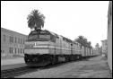 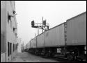 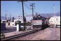 Date: 12/29/07 16:55 Re: Pasadena, CA And The Ex ATSF Second District Author: Des-Lab Also, aren't above pictures 1 and two basically from the same spot, only facing opposite directions? That's one other question I had. Northbound (railroad eastbound) trains encountered two signals in a VERY short distance. Why?
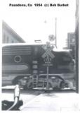
And I thought the distance between two in Glendora were short: eastbound-the one just southeast of Foothill and the Cantilever at Pasadena. Date: 12/29/07 17:00 The "Chief" leaving Pasadena 1960 Author: photobob Man I did not realize that the tracks were all gone at this location. Heres a shot I took of the "Chief" leaving Pasadena Station back in the Summer of 1960.
Robert Morris Photography http://www.snowcrest.net/photobob/index1.html 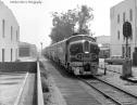 Date: 12/29/07 17:13 Re: Pasadena, CA And The Ex ATSF Second District Author: ats90mph Des-Lab Wrote:
------------------------------------------------------- > Also, aren't above pictures 1 and two basically > from the same spot, only facing opposite > directions? That's one other question I had. > Northbound (railroad eastbound) trains encountered > two signals in a VERY short distance. Why? > Because there used to be a siding at this location, the signals were on each end of the siding. The east end was at Green Street, the west end was at the cantilever signal near Del Mar. I believe when the west end of the siding was intact, the cantilever signal was only for westbound movement, and only had one signal head on it. However when the siding was removed they consolidated the signals onto that bridge, since it was at that point only an intermediate signal, also the signals protected any train in the station. Date: 12/29/07 17:22 Re: Pasadena, CA And The Ex ATSF Second District Author: TopcoatSmith Des-Lab Wrote:
------------------------------------------------------- > Also, aren't above pictures 1 and two basically > from the same spot, only facing opposite > directions? Doubtful, the R-O-W was never paved over between the time it went from a real railroad to a trolley line. TCS - the other r-o-w is still visible in numerous places as is the old UP line. Date: 12/29/07 17:29 Re: Pasadena, CA And The Ex ATSF Second District Author: Des-Lab Re: PhotoBobs pic (which is very nice BTW):
No one mentioned signal #1311 as shown in your picture. So that makes FOUR signals that were in that immediate area. And thank you. All the answers about the siding answer my question. TopCoat: on the day I took the above pictures, I explored most of the Gold Line from Pasadena all the way to just short of the LA river bridge. I followed it into South Pasadena, drove along Marmalade Way (would LOVE to see how THAT looked in the ATSF days), and down. You are right. The Gold Line is not a true railroad. It sort of looks like one with the track, the signals, and the crossing gates. But the similarities end there. Date: 12/29/07 17:36 Re: Pasadena, CA And The Ex ATSF Second District Author: n6nvr And that parking lot at Del Mar, in front of the "antique" brick building? Slim Gauge Guild is in the basement. Used to be real interesting before all the E/Q improvements went in, and most of the foundation views were hidden away and the freights were going by.
Date: 12/29/07 18:13 Re: Pasadena, CA And The Ex ATSF Second District Author: cforssi What is on the old right of way in front of the antique brick building? Was this covering over the tracks or is this some sort of ramp? It is hard to tell from the photo. Looking north towards Raymond Blvd.
Date: 12/29/07 18:58 A couple more... Author: PasadenaSub My first two pictures earlier were probably taken a couple hundred feet apart, as I had to walk north a bit from the station to get the Chief arriving that day. Sadly, homeless people in sleeping bags within 5-10' of the ROW were a common morning sight at the time. I was probably standing about where the north end of the current Gold Line platform is now.
Here's a couple more from Pasadena in the early 90's. I think I've posted these before, but I've left them as uncropped as possible here to show more of the backgrounds. The building with the arched roof on the right in Pic 4 below is the same as in the background to the left of Bob's wonderful picture above. It was a Bank of America credit card payment center at the time, and closed shortly after to relocate operations to Phoenix, AZ. 4) Following behind Amtrak #3 on a foggy morning in July of 1991, ATSF 155 leads a QNYLA (hey John it's your train) past the depot. The station's parking lot to the left was empty and the big dirt lot to the right where the freight house once stood is also evident. 5) In October of 1990, GP60M's galore lead a westbound around the curve south of Glenarm through the City of Pasadena power utility. The remains of a spur can be seen, as well as a private grade crossing (which may have once been a public crossing of Raymond Avenue?). Taken from the Fair Oaks Ave. overpass, with the city of South Pasadena behind me. Rich 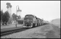 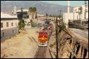 Date: 12/29/07 21:06 Re: Pasadena, CA And The Ex ATSF Second District Author: ats90mph Des-Lab Wrote:
> No one mentioned signal #1311 as shown in your > picture. Signal 1131 (1132 probably for the eastbound) Was the Westbound signal for the east end of the siding. Signal 1313 and it's sister, (probably 1314) both on the signal bridge in later years were for the west side of the Pasadena siding. This siding was relatively short to have two trains in the station at nearly the same time since I recall the siding having a platform as well. The siding also served the Santa Fe Freight depot, which was what the ramp on the east side(railroad south) was for. Date: 12/29/07 23:37 Re: Pasadena, CA And The Ex ATSF Second District Author: mapboy Here's a 7/76 "Topo Map" from
Terra Server- http://terraserver-usa.com/image.aspx?T=2&S=13&Z=11&X=246&Y=2361&W=1&qs=%7cpasadena%7cca%7c It shows the ATSF and UP lines to Pasadena. If you zoom in, it shifts to a 7/94 topo, where you can still see ATSF but not UP. If you click on "Aerial Photo" tab, it's from 6/02. "Urban Areas" is from 3/04. If you go to GlobeXplorer.com, you get a 4/07 color aerial view when you zoom in to any of the first 6 levels. Google Maps aerial view was taken on a different date (unknown date) than Terra Server or GlobeXplorer. I'm on a Mac so I can't get the map website with "live" in the address. So you can compare several modern views- it would be nice to have color aerial views of the '70's! mapboy Date: 12/30/07 08:00 Re: Pasadena, CA And The Ex ATSF Second District Author: SantaFeRuss My hometown railroad. The 2nd district of the Los Angeles division (later known as the Pasadena Subdivision) of the Atchison, Topeka & Santa Fe Railway.
You guys have covered pretty much everything regarding the route through Downtown Pasadena. But in the 1960's and early 1970's the station in Pasadena was blessed with the mainline and siding and other tracks and even a train order signal right next to the station. No one has mentioned this, but the siding between Green street and just south (railroad west) of Del Mar Bl had dwarf signals at both ends. As someone did say, the canilevered signal for westbound movements south of Del Mar was a one head affair. Only later did Santa Fe put the other head on for eastbounds after the siding and other tracks were removed. There was an eastbound signal at the west switch of the siding before that. Santa Fe actualy had one more track next to the siding for the freight house. The mainline, siding, freight house spur and the other 2 tracks for the ramp next to Arroyo Parkway all came together south of the crossing at Del Mar Bl. The Del Mar crossing had a total of 5 tracks. This was noted on the crossing signals. The early 1970's saw the end of the freight house, but the ramp remained into the 1980's. Special note: The ATSF freight ramp was covered and it also had a wonderful large neon Santa Fe logo! Also interesting was that all the mainline signals in the area were color-light types except the eastbound signal for the mainline at Green street. This one was a searchlight type. The dwarf signals were both serchlights as well. Far as I know Pasadena was the only siding that had dwarf singnals between Los Angeles and San Bernardino. Many times, as a kid, I would see the 2nd district local in the siding as the Super Chief/El Capitan and later the Amtrak Southwest Ltd would load and unload passengers at Pasadena. I would say the passing track at Pasadena would hold about a 25-30 car freight including two locos and a caboose. No more than that. Lots of memories! From the mid 1970's to the closing of the line in 1994, Santa Fe ran mainline freights through Pasadena. Most were westbound intermodal trains. Even saw the Union Pacific CLS (California Livestock Special) detour westbound through Pasadena with two types of pigs on it! Real pigs in UP stock cars and the rest of the train was piggyback TOFC. Before the mid-seventies only locals and passenger trains ran. The Gold line does not do it any justice. Its better to have some rail activity in Pasadena than none at all, I suppose. SantaFeRuss Date: 12/30/07 08:28 Re: Pasadena, CA And The Ex ATSF Second District Author: Lee_in_KC In 1979 I worked for a company called Digitran, which at the time had a plant at 855 S. Arroyo and its main office across the ATSF tracks to the west, fronting on Raymond. My office was in the Raymond building, but I was back and forth between the two buildings at least a half-dozen times a day. There was a walkway that crossed the tracks and there were actually miniature crossing signals for the pedestrians. It was quite a coincidence that every time I heard a train blowing for the grade-crossings north and south of us, I needed to go the other building just as the locos reached our pedestrian crossing! ;) Standing at the crossing signals you were no more than about six feet from the side of the train.
Date: 12/30/07 12:11 Re: Pasadena, CA And The Ex ATSF Second District Author: iliketrains I worked the Pasadena Station for Amtrak in the summer of 1974. Excellent job.
Only Del Mar was better. Date: 12/30/07 12:47 Pasadena Freight Shed Author: PasadenaSub Our own NscaleMike posted a couple of images of the freight house between the depot and Arroyo Parkway about a year ago:
http://www.trainorders.com/discussion/read.php?11,1304109 Date: 12/30/07 14:59 Re: Pasadena Freight Shed Author: DNRY122 And if you push the "Way Back Machine" a little harder, the route from Pasadena to Arcadia in the pre-210 freeway days wandered past residential back yards and involved about two dozen grade crossings, many of them protected by Magnetic Flagman wigwags. I remember riding ATSF train 23 through Pasadena in the pre-dawn darkness and hearing the clank of wigwags as we poked along. Some of this right of way is still visible north of Walnut Ave. at Hill Ave. West of Allen, it's part of Davis Lumber and a few blocks east, where Foothill blends into Walnut, the local Honda dealer has taken it over. East of this point it parallels Walnut and is gradually being "repurposed" for various commercial activities. Sierra Madre Blvd once had a Pacific Electric line in the median, and Lamanda Park tower protected the crossing until 1950. Further east, the ATSF Lamanda Park station remained for several years after the 210 rerouting, since the track in this area was kept as a spur to serve Davis Lumber and a few other customers. One relic that won't disappear any time soon is the tunnel under the eastbound lanes of the 210 for the connection from the original track to the new route.
I realize that we all have personal points of view on the railroad scene, so I have to stand up and say "I LIKE the Gold Line". As a native of the San Gabriel Valley, who saw the PE lines scrapped in the early 1950's, being able to travel from Pasadena to LA on an electric railway again was worth the 50+ year wait. I would rather Metro had rebuilt the Short Line and left the Santa Fe route for Amtrak, but in the immortal words of Mick Jagger, "You can't always get what you want", and at least I can take to Gold Line to Union Station and go off in any direction from there. Date: 12/30/07 15:54 Re: Pasadena Freight Shed Author: danf Well since you mentioned Magnetic Flagman wigwags on this line, here's one from downtown there...
 Date: 12/30/07 18:09 Re: Pasadena, CA And The Ex ATSF Second District Author: n6nvr TopcoatSmith Wrote:
------------------------------------------------------- > Des-Lab Wrote: > -------------------------------------------------- > ----- > > Also, aren't above pictures 1 and two basically > > from the same spot, only facing opposite > > directions? > > Doubtful, the R-O-W was never paved over between > the time it went from a real railroad to a trolley > line. > > > TCS - the other r-o-w is still visible in numerous > places as is the old UP line. Much as I hate to contradict the master but #1 is looking north across Colorado. #2 is looking north towards Colorado Blvd from about a block south. As far as the tracks in front of the brick building, I'm thinking you are referring to where they go underneath/through the buildings at Del Mar. (This is assuming you are looking at an aerial view) If you go to the south end of that tangent to Glenarm St, the Gold Line swings to the west side of Raymond Hill, site of the Raymond Hotel, the Raymond station and a still existing original pre-Pacific Electric substation building. Both the Santa Fe and the UP swung around west of the hill, between the hill and the power plant, the UP then swinging west of Fair Oaks and then north. The SP branch came up east of the freeway and Raymond Hill and then street ran up to Colorado. The original Santa Fe alignment ran east and then north to Lamanda Park. There was a remnant of the Santa Fe spur that ran east across the the SP a up to an industry about a block east of the freeway up into the 60's. Until just a few years ago, the freeway didn't officially start until about a hundred feet south of Glenarm, because you couldn't have a grade crossing on a freeway. So if you looked you would see the "Begin Freeway" signs down by the power plant coolers instead of up at Glenarm. Unfortunately I had a hard drive failure and I haven't restored many of my scans but here is where the Santa Fe/Gold Line and former UP tracks separate in South Pasadena at Fremont and the Pasadena Freeway 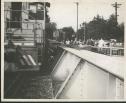 Date: 12/31/07 00:13 Re: Pasadena, CA And The Ex ATSF Second District Author: MP12HarborSub ats90mph Wrote:
------------------------------------------------------- > Des-Lab Wrote: > > > No one mentioned signal #1311 as shown in your > > picture. > > Signal 1311 (1312 probably for the eastbound) Was > the Westbound signal for the east end of the > siding. Signal 1313 and it's sister, (probably > 1314) both on the signal bridge in later years > were for the west side of the Pasadena siding. > This siding was relatively short to have two > trains in the station at nearly the same time > since I recall the siding having a platform as > well. The siding also served the Santa Fe Freight > depot, which was what the ramp on the east > side(railroad south) was for. Signal 1311 was east (north of the Green St Crossing) to the left of Signal 1312 1311 was a US&S Style R2 (three exterior lenses vertically mounted on the head) 1312 was a US&S style H5 searchlight 1313 was originally on a mast but Santa Fe mounted it on the signal bridge that held Signal 1314 after they tore up the Pasadena Yard, and they were also R2's |