| Home | Open Account | Help | 271 users online |
|
Member Login
Discussion
Media SharingHostingLibrarySite Info |
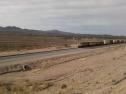
Western Railroad Discussion > First Pic of the UP on Their New Alignment (Marsh, AZ)Date: 01/23/12 07:57 First Pic of the UP on Their New Alignment (Marsh, AZ) Author: Amtk509 My good friend and fellow TO'er TucsonPete sent me this from last weekend. An eastbound intermodel on the new alignment as it approaches the overpass connecting Marsh Station Rd. and I-10. Can't make out the unit numbers as this was done from a basic cell phone camera.
 Date: 01/23/12 10:05 Re: First Pic of the UP on Their New Alignment (Marsh, Author: billio Nice. Thanks for reporting.
Date: 01/23/12 12:56 Re: First Pic of the UP on Their New Alignment (Marsh, Author: cutboy2 Future double track??
Date: 01/23/12 14:56 Re: First Pic of the UP on Their New Alignment (Marsh, Author: kdrtrains This is the south track of double track. The tracks are just not together here. They may put in a siding here but I would think not.
KR Date: 01/23/12 15:29 Re: First Pic of the UP on Their New Alignment (Marsh, Author: SVTS If you are slightly familiar with this area, UP has a grade seperation east of Tucson, from Vail to Mescal with the famous Cinega creek bridge roughly in the middle. the old main line swung out south over I-10, through a horseshoe curve, then back under I-10. This new section of track is roughly 2 miles long (I'm just guessing, so don't flame me with "It's 2.5 miles long!") and runs along side I-10 just about in a straight line. Not really much shorter but amazing how such a small project can save so much time. I don't live in the area, so I don't know if UP paid for the entire project or if the state kicked in some, as I imagine this was a joint effort to do away with the older Marsh Station Rd exit and the UP overpass right after it, both were narrow overpasses. Maybe someone local can shed some light on the overall project.
Chris Bogley Bowie, MD Date: 01/23/12 16:55 Re: First Pic of the UP on Their New Alignment (Marsh, Author: Narniaman kdrtrains Wrote:
------------------------------------------------------- > This is the south track of double track. The > tracks are just not together here. They may put in > a siding here but I would think not. > > KR I'm having problems getting my mind around your statement. . . so is there a north track that we don't see? I thought this track was just north of I-10, and the old track was south of I-10. Date: 01/23/12 18:21 Re: First Pic of the UP on Their New Alignment (Marsh, Author: CLM Yes, there is a north track...and, yes, this track is north of I10 and the old track is south of I10.
Date: 01/23/12 19:00 Re: First Pic of the UP on Their New Alignment (Marsh, Author: BCHellman SVTS Wrote:
------------------------------------------------------- > If you are slightly familiar with this area, UP > has a grade seperation east of Tucson, from Vail > to Mescal with the famous Cinega creek bridge > roughly in the middle. the old main line swung > out south over I-10, through a horseshoe curve, > then back under I-10. This new section of track > is roughly 2 miles long (I'm just guessing, so > don't flame me with "It's 2.5 miles long!") and > runs along side I-10 just about in a straight > line. Not really much shorter but amazing how > such a small project can save so much time. I > don't live in the area, so I don't know if UP paid > for the entire project or if the state kicked in > some, as I imagine this was a joint effort to do > away with the older Marsh Station Rd exit and the > UP overpass right after it, both were narrow > overpasses. Maybe someone local can shed some > light on the overall project. The state/feds paid for this realignment so ADOT could eliminate a hi-wide restriction on Interstate 10 where the railroad crossed the freeway at Pantano, which was requiring trucks to detour via Elgin. When I was there last summer the ROW was completed, but no track. The horseshoe curve was near Buell and was 10 degrees. Though the off-ramp near the now-eliminated overpass was call Marsh Road, Marsh is on the number 1 main (ex-EP&SW) some distances from the line relocation. The overpass is nearer to Pantano. |