| Home | Open Account | Help | 249 users online |
|
Member Login
Discussion
Media SharingHostingLibrarySite Info |
Western Railroad Discussion > Google Maps QuestionDate: 05/03/16 13:10 Google Maps Question Author: StStephen I've been following the progress of UP's Mesquite Intermodal/Auto expansion/remodel on Google Maps. The aerial satellite image varies from day to day. Some days it will show the new ramp tracks and the new ladder/lead at the north end at Samuell Blvd as well as the newer west wye leg, plus the new 2MT/siding project; other times those aren't there and it shows earlier construction versions. This can vary during the same day. Today is an example: My question: is there some setting that allows a continuous feed of the latest aerial? Does anyone know why this changes as often as it does and, more specifically, why it would go back in time???
The attached picture shows how it looks this afternoon. I did not do a screen capture this morning when it showed the newer construction. Bruce  Date: 05/03/16 14:44 Re: Google Maps Question Author: Auburn_Ed Wow. I certainly didn't think Google updated any of their maps anywhere near that often. Maybe we are approaching the day of real-time satellite imagery for the masses.
Ed Date: 05/03/16 14:54 Re: Google Maps Question Author: TCnR There is a market for information updated more often and there are projects in the works but, for some reason, they expect to be paid for that info. The commercial info will not be 'streamed' but will be from numerous Low-Earth-Orbit micro-satellites. Pretty hot market in some Valleys of the world.
Date: 05/03/16 16:59 Re: Google Maps Question Author: bowtie A few years ago I noticed that Google Maps was using different images depending on which direction the map was facing. For example, when I would look up the 8th St. yard near LAUPT, views pointing North were different from views pointing South, etc. Not sure if that is the case anymore, but it's worth a thought.
-Martin Date: 05/03/16 17:07 Re: Google Maps Question Author: KA7008 If you use "Google Earth", you can change the slider at the bottom and go "back in time" to alter the date of the imagery.
Date: 05/03/16 21:28 Re: Google Maps Question Author: loopy7764 bowtie Wrote:
------------------------------------------------------- > A few years ago I noticed that Google Maps was > using different images depending on which > direction the map was facing. For example, when > I would look up the 8th St. yard near LAUPT, views > pointing North were different from views pointing > South, etc. Not sure if that is the case > anymore, but it's worth a thought. > > -Martin Are you referring to the aerial views (not the overhead satellite imagery) Google "hid" from their new version of Maps last year? It's hard to access now is there an easier way? Date: 05/04/16 07:29 Re: Google Maps Question Author: ColoradoRailfan Hello Bruce!
I'm guessing that these two images are the two that you are seeing. Check out my next reply for an explanation of the differences... Kevin Morgan Arvada, CO ColoradoRailfan.com Edited 1 time(s). Last edit at 05/04/16 10:16 by ColoradoRailfan.   Date: 05/04/16 07:32 Re: Google Maps Question Author: ColoradoRailfan Google Maps has a "3D" feature that can be turned on or off. When on, the satellite imagery can show 3D buildings, etc. The imagery for "3D" vs "non-3D" is different. I'm guessing the 3D option is different for you (perhaps on two different computers)? You can check the setting by going to the Google Maps menu (see picture 1 on this reply). Then, you can see where the setting is either set to "3D on" or "3D off" (see pictures 2 and 3 in this reply). You can click on that to change the setting and the imagery will refresh.
The two different images are, of course, taken at different times. Depending on when they were taken, there are noticable differences in the features on the ground. Hope this helps! Kevin Morgan Arvada, CO ColoradoRailfan.com 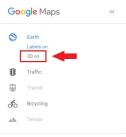 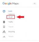 Date: 05/04/16 10:08 Re: Google Maps Question Author: StStephen Kevin, thanks so much for that info! I never realized that 3D on/off had that impact. I just did that (on Google Maps) and watched it go from the newer aerial (3D off) to the older one (3D on).
KA7008, thanks also, tried that one too on Google Earth: for some reason mine was set to 1995! I slid to current and got the latest aerial there too. Thanks again to both of you, Bruce Edited 1 time(s). Last edit at 05/04/16 10:12 by StStephen. Date: 05/04/16 12:17 Re: Google Maps Question Author: ATSF93 Also, the imagery on Earth has dates, which is not available in the maps, until you go to street view. Unless they have changed it....
Fred in Wichita |