| Home | Open Account | Help | 315 users online |
|
Member Login
Discussion
Media SharingHostingLibrarySite Info |
Western Railroad Discussion > UP Paramount Switch in Long Beach CADate: 01/21/17 21:18 UP Paramount Switch in Long Beach CA Author: erielackawanna On January 14 the Union Pacific Paramount Switcher has just crossed the Los Angeles River in Long Beach and is now following a huge storm drain as it heads up towards its namesake city of Paramount. This section of the Los Angeles & Salt Lake cutoff has mostly been encased in sound walls and there are very few spots to shoot a train on it.
Edited 1 time(s). Last edit at 01/21/17 21:45 by erielackawanna. 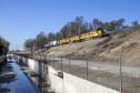 Date: 01/21/17 22:49 Re: UP Paramount Switch in Long Beach CA Author: cchan006 Nice catch, Charles!
Sorry to hijack, but before asking any questions, I found your location (fore!) using the excellent, concise description you posted, and comparing the track curvature noticeable in your shot to a satellite view, which lacked any water in the storm drain. I'm preaching against spoon-fed railfanning here. :-) Didn't know the tracks are part of the LA&SL... and no kidding about the sound walls! (based on Google Street View along the ROW) Date: 01/21/17 22:51 Re: UP Paramount Switch in Long Beach CA Author: erielackawanna Charles - HA HA - not hiding it from anyone at all. It's the little tiny park east of the LA River along the tracks.
Would love to meet you down there one day. Date: 01/21/17 23:21 Re: UP Paramount Switch in Long Beach CA Author: mapboy This stretch of UP track, from Douglas Jct. to Terminal Island, was built to get the freight traffic off the streets of downtown Long Beach. That's why the raised grade separated right-of-way along this stretch. Thanks for getting shots along a line not often photographed!
mapboy Date: 01/21/17 23:45 Re: UP Paramount Switch in Long Beach CA Author: Coalca That's a great catch. I'm surprised those gen sets aren't covered in graffiti like most I've seen down there.
Date: 01/22/17 06:48 Re: UP Paramount Switch in Long Beach CA Author: 3rdswitch Nice shot. Before the sound walls used to catch the locals and extras often on that stretch but never that far west.
JB Date: 01/22/17 07:59 Re: UP Paramount Switch in Long Beach CA Author: TomPlatten I also note that the Genset units seem to have become reliable enouigh to send out without a conventional unit in the consist. I talked to a UP official four or five years ago and he told me they were "going to make them work". I guess they have!
Date: 01/22/17 09:12 Re: UP Paramount Switch in Long Beach CA Author: CimaScrambler Nice shot! When I first saw it, I was thinking you were on the bridge at Long Beach Blvd. Looks like that park could use a visit.
- Kit Kit Courter Menefee, CA LunarLight Photography Date: 01/22/17 09:16 Re: UP Paramount Switch in Long Beach CA Author: erielackawanna Just a little bit east of there, Kit. It's a public park and totally legal. The river is weird there with two channels running side-by-side. I did try a shot once with a friend from the west stream and it totaly does not work due to the high-girder bridge. There might be shot from the east stream, but I think that would involved trespass (not railroad trespas, but fences protecting the river) and I'm not convinced you could get high enough to solve the girder obstruction anyway.
Date: 01/22/17 11:28 Re: UP Paramount Switch in Long Beach CA Author: CPRR Great photo. How often does this line still get a train from Terminal Island to LA and beyond? Sounds crazy but I wish Metrolink would buy it and rebuild to handle their trains
Posted from iPhone Date: 01/22/17 11:55 Re: UP Paramount Switch in Long Beach CA Author: erielackawanna I've heard rumors that it happens on occasion but I sure as heck have never ever seen it.
Date: 01/22/17 16:22 Re: UP Paramount Switch in Long Beach CA Author: jst3751 The "east" river is the Rio Hondo riverbed which is formed from the Santa Anita and Arcadia washes as well as the Eaton Wash. Basiclly the Rio Hondo is the collector for all the western San Gabrial Valley roughly boardered by Lake St, Atlantic Ave on the west to just west of the San Gabriel river on the East
Date: 01/22/17 21:02 Re: UP Paramount Switch in Long Beach CA Author: mapboy jst3751 Wrote:
------------------------------------------------------- > The "east" river is the Rio Hondo riverbed which > is formed from the Santa Anita and Arcadia washes > as well as the Eaton Wash. Basiclly the Rio Hondo > is the collector for all the western San Gabrial > Valley roughly boardered by Lake St, Atlantic Ave > on the west to just west of the San Gabriel river > on the East You are thinking of the upper crossing of the L.A. River and Rio Hondo in South Gate (I once walked across the L.A. River truss bridge as a kid). This is the lower crossing in Long Beach. The east channel that erielackawanna is talking about is used for groundwater recharging. Excess water is channeled down that side and it sinks into the soil and then is pumped out for use by the people of Long Beach. Google aerial view- https://goo.gl/maps/figYeL5CAnp Note Blue Line at the bottom left crossing over UP. The previous PE-UP at-grade crossing was called Cota. Date: 01/23/17 07:29 Re: UP Paramount Switch in Long Beach CA Author: jst3751 mapboy Wrote:
------------------------------------------------------- > jst3751 Wrote: > -------------------------------------------------- > ----- > > The "east" river is the Rio Hondo riverbed > which > > is formed from the Santa Anita and Arcadia > washes > > as well as the Eaton Wash. Basiclly the Rio > Hondo > > is the collector for all the western San > Gabrial > > Valley roughly boardered by Lake St, Atlantic > Ave > > on the west to just west of the San Gabriel > river > > on the East > > You are thinking of the upper crossing of the L.A. > River and Rio Hondo in South Gate (I once walked > across the L.A. River truss bridge as a kid). > This is the lower crossing in Long Beach. The > east channel that erielackawanna is talking about > is used for groundwater recharging. Excess water > is channeled down that side and it sinks into the > soil and then is pumped out for use by the people > of Long Beach. Google aerial view- Note > Blue Line at the bottom left crossing over UP. > The previous PE-UP at-grade crossing was called > Cota. Yep your right. I missed the part where he said it was going UP towards Paramount, not Down towards Paramount as Paramount is more/less between those 2 points. |