| Home | Open Account | Help | 251 users online |
|
Member Login
Discussion
Media SharingHostingLibrarySite Info |
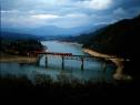
Steam & Excursion > Your help neededDate: 02/16/17 10:56 Your help needed Author: Ardenwood I dug this up. All I remember is poison ivy of the place I shot this. Which way is the train going? The date I wrote is May 6, 1984 but is that right?
 Date: 02/16/17 11:14 Re: Your help needed Author: callum_out North, isn't that the Lakehead Bridge on Shasta?
Out Date: 02/16/17 11:19 Re: Your help needed Author: HotWater callum_out Wrote:
------------------------------------------------------- > North, isn't that the Lakehead Bridge on Shasta? > > Out No such thing as "North" on the SP. If it was indeed taken in May 1984, then the New Orleans Worlds Fair Daylight is Westbound (compass South), enroute to Sacramento for layover, prior to moving to San Francisco. Date: 02/16/17 12:44 Re: Your help needed Author: KD6PYD The train is too short to be the Louisiana Worlds Fair Daylight.. I'm thinking that is the Tough Guys movie special in 1986.
Keith Date: 02/16/17 12:54 Re: Your help needed Author: callum_out Compass North, Eastbound and that does look like the Tough Guys train. Jack, I'll see you at Midwest
and we can discuss it! Out Date: 02/16/17 13:08 Re: Your help needed Author: HotWater callum_out Wrote:
------------------------------------------------------- > Compass North, Eastbound and that does look like > the Tough Guys train. Jack, I'll see you at > Midwest > and we can discuss it! > > Out Sounds like a deal. Since the original poster stated that it was May 1984, I therefor ASSUMED that he knew what he was talking about. If 1986, then of course it is indeed the Tough Guys Daylight. Date: 02/16/17 15:17 Re: Your help needed Author: gbmott Has anyone mentioned that it is a really nice photo . . . ?
Gordon Date: 02/16/17 19:48 Re: Your help needed Author: Hillcrest Harou takes a nice photo...many of them, actually! Just had a discussion today about what the level of Lake Shasta is like right now...
Cheers, Dave Date: 02/16/17 21:56 Re: Your help needed Author: SP4436 No definitely heading west. About to duck into the tunnel 10 and 9 where it will then come out at the east switch of Mead siding.
callum_out Wrote: ------------------------------------------------------- > Compass North, Eastbound and that does look like > the Tough Guys train. Jack, I'll see you at > Midwest > and we can discuss it! > > Out Edited 2 time(s). Last edit at 02/16/17 22:06 by SP4436. Date: 02/17/17 08:45 Re: Your help needed Author: LarryB Most likely poison oak rather than poison ivy. Yes, it's a super pic. Golly, it seems like yesterday that I chased her in the valley.
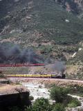
Edited 2 time(s). Last edit at 02/17/17 08:47 by LarryB. Date: 02/17/17 11:44 Re: Your help needed Author: Ardenwood I dug another one up. It is near the Oregon-California boder. It looks like the same short train.
 Date: 02/17/17 12:27 Re: Your help needed Author: johnacraft Ardenwood Wrote:
------------------------------------------------------- > I dug another one up. It is near the > Oregon-California boder. It looks like the same short train. This looks like May 1 1989, when 4449 deadheaded from Portland to Oakland on the way to LAUPT 50th anniversary. Date: 02/17/17 12:46 Re: Your help needed Author: HotWater Ardenwood Wrote:
------------------------------------------------------- > I dug another one up. It is near the > Oregon-California boder. It looks like the same > short train. Nope. Note that there is no auxiliary water tender. Date: 02/18/17 01:40 Re: Your help needed Author: E25 The first photo shows the trestle located at the south end of Lakeshore, CA
The "Lakehead" trestle is actually at the north end of the town of Lakeshore, here: http://www.railpictures.net/photo/544231/ The "real" Lakehead community is a mile or two to the north of Lakeshore, just past Antlers. Ardenwood can claim membership in a rather small group of photographers who have actually ventured out to this point looking down on the bridge. TO member Rod Loder was the person who first clued me into this location for the World's Fair Daylight trip. The nearest forest service road ended about a mile from the viewpoint. It was "every man for himself" trying to get through the frustratingly thick, nearly impenetrable brush, poison oak TREES, gnarly, tough manzanita, etc. I was lugging a tripod with three cameras attached through this mess and barely made it to the viewpoint in time to catch the train. To reduce my exposure to the 6-foot high poison oak bushes, I had purchased a head-to-toe mechanic's suit which I wore it in and out from the end of the forest service road and bagged it up as soon as I got back to my car. It worked, and I never developed any poison oak. One trip into that place was enough to last a lifetime... LOL Edited 1 time(s). Last edit at 02/18/17 02:31 by E25. Date: 02/18/17 05:00 Re: Your help needed Author: apollo17 Great shot! Looks like the river or lake was bit low that year.
Date: 02/19/17 13:35 Re: Your help needed Author: Ardenwood Thank you Callum_out, HotWater, KD6PYD, gbmott, Hillcrest, SP4436, LarryB, johnacraft, E25, appolo17. I learned that it was not poison ivy but poison oak. So the second picture was on the way to this.
 Date: 02/19/17 13:53 Re: Your help needed Author: HotWater Ardenwood Wrote:
------------------------------------------------------- > Thank you Callum_out, HotWater, KD6PYD, > gbmott, Hillcrest, SP4436, LarryB, johnacraft, > E25, appolo17. I learned that it was not poison > ivy but poison oak. So the second picture was on > the way to this. Probably, yes. 1989. Date: 02/19/17 14:34 Re: Your help needed Author: portlander SP4436 Wrote:
------------------------------------------------------- > No definitely heading west. About to duck into > the tunnel 10 and 9 where it will then come out at > the east switch of Mead siding. > Exactly this. The signals just off of the bridge are no longer there. They were moved just south of tunnel 10. Also of note, the compass north end of this bridge is above the often photographed abandoned tunnel from the original pre-dam right of way. Additionally, Mead Siding is long gone. |