| Home | Open Account | Help | 365 users online |
|
Member Login
Discussion
Media SharingHostingLibrarySite Info |
Nostalgia & History > Santa Fe Dam - (CA) trackageDate: 09/08/08 09:51 Santa Fe Dam - (CA) trackage Author: atsffan .
Edited 1 time(s). Last edit at 12/12/15 09:43 by atsffan. Date: 09/08/08 12:34 Re: Santa Fe Dam - (CA) trackage Author: switchlamp I saw 3 old SP locomotive cranes being scrapped on this piece of track in the mid 90's .
Date: 09/08/08 14:15 Re: Santa Fe Dam - (CA) trackage Author: UPNW2-1083 atsffan Wrote:
------------------------------------------------------- > I do a regular bike ride out to the Santa Fe dam > in Irwindale and cross a set of abandoned tracks > that cut across from east to west from the > industrial area near the current active branch and > seem to continue across the bottom of the dam. The > tracks are located on the Santa Fe dam's entry off > Arrow Highway. > > I vaguely remember the tracks going along the > bottom of the dam in the 1970s next to Arrow > Highway. Can anyone tell me details as to where > these tracks came from/went to? Maybe a gravel pit > or concrete/concrete pipe plant? > > Ex-SP (likely) or ex-PE (a little less likely)? > > Richard I remember the tracks also in the early 60s, as we used to travel along Arrow hwy between Covina and Alhambra to visit my grandparents. IIRC the trackage at the bottom of the dam was PE/SP. Try checking out http://www.historicaerials.com/ , and type in Irwindale, Ca. and you can view the area back to 1948! You can zoom in on any area to get a closer look.-BMT Date: 09/08/08 15:25 Re: Santa Fe Dam - (CA) trackage Author: rehunn The part of the line next to Arrow Highway served a Hydro-Conduit pipe plant for many
years. In fact Hydro had their own Plymouth switcher which saw occasional use. The line I believe was post PE and constructed when SP built the line north to the Azusa- Monrovia ex-PE line. Date: 09/08/08 17:19 Re: Santa Fe Dam - (CA) trackage Author: NWP-Dispatcher It was indeed the PE's line, branching off their Crushton (aka Reliance Rock) spur up from the San Bernardino Line, shown on the attached Google Earth screenshot. I don't have anything showing the extent of the line along Arrow Highway west of what's in red, nor any info about its operation.
The original (1926) Reliance Rock spur was about 1/4 mile west of the current line, and came up between Azusa Canyon Rd and Lante St, and right thru where east side of the dam is, and up to the Reliance Plant, where PE had a 125-car yard. With construction of the dam in the 1940s, the line was moved east. rehunn Wrote: ------------------------------------------------------- > The part of the line next to Arrow Highway served > a Hydro-Conduit pipe plant for many > years. In fact Hydro had their own Plymouth > switcher which saw occasional use. That's probably the area adjacent to the curve just north of Arrow Highway, which the SP valuation map - http://harrymarnell.net/SantaFeDam.pdf - shows as granted to PE by United Conc Pipe Co in 1952 and 1953. EDIT: Or probably not... I guess Hydro-Conduit was much farther west? 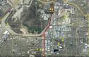 Date: 09/08/08 17:25 Re: Santa Fe Dam - (CA) trackage Author: TopcoatSmith That was a dam good question, and it got answers too. I recall crossing rails on the way to RenFaire at SFD.
TCS - clan anderson maybe ? Date: 09/08/08 17:51 Re: Santa Fe Dam - (CA) trackage Author: africansteam The PE system map on the ERHA website shows the trackage at the base of the dam as belonging to SP.
http://www.erha.org/pe_system_map.jpg By opening two windows - one with the current Google map, and one with the PE map, and scaling them to roughly the same size you can get pretty good feel for the route. Cheers, Jack Date: 09/08/08 18:29 Re: Santa Fe Dam - (CA) trackage Author: NWP-Dispatcher africansteam Wrote:
------------------------------------------------------- > The PE system map on the ERHA website shows the > trackage at the base of the dam as belonging to > SP. > > http://www.erha.org/pe_system_map.jpg Except for the fact that PE merged into SP in 1965 (long after the PE map, of course), I'm not really seeing that, Jack. The closest SP trackage would have been the Basset-Covina-Pomona line down at Los Angeles Street in Baldwin Park, from which the PE Crushton spur branched; or else the SP Duarte Branch which PE acquired in 1942, before the dam was built, but that was up north of Huntington Drive. ATSF was just north of the dam. Date: 09/08/08 19:07 Re: Santa Fe Dam - (CA) trackage Author: DNRY122 According to "Interurbans Special 61", the "PE 1976" section covering remnants of the Red Car system: At Orange Ave. Junction [on what is now the Metrolink line] the Azusa Branch heads north through Irwindale. Just north of Arrow Highway is a team track and a long spur to United Concrete Pipe. UCP's six-wheel Plymouth switcher sometimes comes over to the team track to pick up or return a bulkhead flat. One story I heard about the Plymouth was that it was missing a drive chain, making it a B-1 or an 0-4-2T. Note that in 1976, Miller Brewing was still using the former Lucky Lager plant in Azusa on the ex-PE Monrovia-Glendora line, which was switched by a job out of Baldwin Park. The typical crews working out of Baldwin Park had PE seniority and some of them had stories to tell about the Red Car era. The current brewery site was occupied by the Irwindale Raceway, where drag races livened up the weekends.
Date: 09/08/08 23:24 Re: Santa Fe Dam - (CA) trackage Author: GRNDMND It was indeed a spur over to United Concrete Pipe, and the line was used sporadically by UCP. Saw it in operation on two occasions (company I worked for was on the south side of Arrow Hwy across from the dam) both times it was the Plymouth with one car loaded with a rather large form for making the huge concrete pipe. I also seem to remember hearing a story about that switcher missing a drive chain. As it trundled along that spur at the base of the dam it looked so minute in comparison. I have included a shot I took over the fence at UCP on 7/24/71 of the little jewel in question. Sorry, I was not able to shoot it "long the line".
KC - best little switcher by a damn site 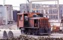 Date: 12/22/12 11:14 Re: Santa Fe Dam - (CA) trackage Author: SteveD I recall the spur in question reaching all way west to River on topo maps, assumed it might have served a water processing facility.
Steve Donaldson Pacific Grove, CA |