| Home | Open Account | Help | 290 users online |
|
Member Login
Discussion
Media SharingHostingLibrarySite Info |
Nostalgia & History > 1938 Los Angeles FloodDate: 02/14/09 14:10 1938 Los Angeles Flood Author: odub Starting in late February of 1938, rain started to fall at an incredible rate on southern California. One report I found indicated that up to 10 inches of rain fell in five days. By the first of March, the Los Angeles, San Gabriel, and Santa Ana Rivers were all well above flood stage. Approximately 115 people died in the floods and over 5,600 homes were destroyed.
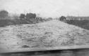
The flooding stopped all operations into and out of LA on the SP, UP, and ATSF and also shut down most PE activities. My Dad was 19 at the time, shooting with a box camera and processing and printing his own film. Found these prints in an old family photo album last night and thought some of you would find in interesting. Don't know much about them, but I'm guessing that a number of you can give me good locations. My Dad lived in Highland Park at the time so I'm guessing images aren't real far from there - most likely along the Los Angeles River down near Taylor Yard. If you'd like to see more of the flood (no rail action, though) here a some links: http://www.geocities.com/Heartland/Ranch/1916/laflood.html http://www.efootage.com/play_clip.php?clip_id=61436 Don Hall Yreka, CA 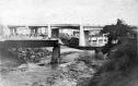 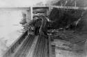 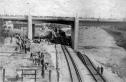 Date: 02/14/09 14:11 Re: 1938 Los Angeles Flood Author: odub Non-rail shots. First is the flood coming down the Arroyo Seco just below the Rose Bowl. Second has no information attached.
  Date: 02/14/09 14:28 Re: 1938 Los Angeles Flood Author: UPNW2-1083 The first two are of the SP bridge that connected Taylor at Dayton tower to the Cornfield and Bullring (I don't remember the name of the small yard to the right, the "Links" maybe?). The third shot is of the east bank of the L.A. River. You can see the city jail building just under the bridge on the right. The jail building is still there today.-BMT
Date: 02/14/09 14:38 Re: 1938 Los Angeles Flood Author: agentatascadero Could this be the flood that caused the subsequent concrete jungle? AA
Stanford White Carmel Valley, CA Date: 02/14/09 14:42 Re: 1938 Los Angeles Flood Author: odub This was the flood that convinced the powers that be that straight, concrete lined ditches would be more effective.
Date: 02/14/09 14:43 Re: 1938 Los Angeles Flood Author: xtra1188w This is sort of an interesting coincidence, just a few hours ago I read a story (fiction) that featured Eddie Sand the boomer telegrapher who went to work for the PE at their Whittier station, and shortly afterwards there was a flood of monumental proportions happened in So Cal that shut down everything in the LA area except for the Santa Fe and bits and pieces of the PE. This crisis was the focus of the story and how Eddie figured how to deal with this crisis as only he could do. Those old stories were corny maybe, but they make fine reading even today. This story was first printed in 1940 I think in Railroad Man's magazine. I don't think that Corny is a word that's still being used by our culture too much these days, but way back then it was.
Con Date: 02/14/09 15:33 Re: 1938 Los Angeles Flood Author: winstonhill John Signor's Tehachapi book has an excellent account of the 1938 flood and its effects on Tehachapi and Soledad Canyon. A real rip-snorter, by all accounts.
Winston Hill Date: 02/14/09 17:06 Re: 1938 Los Angeles Flood Author: crackerjackhoghead odub Wrote:
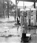
------------------------------------------------------- > This was the flood that convinced the powers that > be that straight, concrete lined ditches would be > more effective. How quickly they forget too. Now communities are pushing for the removal of the concrete lining and letting trees grow back to create "green belts". I'm all for nature but just wait 'til all those trees, growing along the wash in Glendale, wash down stream, lodge against a bridge somewhere and create a dam. Date: 02/14/09 18:07 Re: 1938 Los Angeles Flood Author: scottp The youngster seems to be "at the gas station without a paddle" or, setting up for a homemade tribute to "FLASH" Gordon (note the robots standing at attention in the background.)
With the concrete channels we say "Yikes! Look at that!" as the water rushes by... and a week later we go back to trying to figure out how to deal with the drought. Date: 02/14/09 19:06 Re: 1938 Los Angeles Flood Author: DRGW5502 Very cool pictures, thanks for posting.
Date: 02/15/09 02:04 Re: 1938 Los Angeles Flood Author: SPLoopConductor scottp Wrote:
------------------------------------------------------- > > With the concrete channels we say "Yikes! Look at > that!" as the water rushes by... and a week later > we go back to trying to figure out how to deal > with the drought. Isn't that the truth! Even at a young age, growing up a couple of blocks from the river, I always wondered why we just let that flow to the ocean... while we actually live in a desert-like area of California! (You can still see the old, un-used spreading ponds out in the San Fernando Valley. The wackos say let the 'polluted' water go into the Pacific. Take Care, Stay Safe, Have Fun! Larry Date: 02/15/09 02:35 Re: 1938 Los Angeles Flood Author: espeeboy UPNW2-1083 Wrote:
------------------------------------------------------- > The first two are of the SP bridge that connected > Taylor at Dayton tower to the Cornfield and > Bullring (I don't remember the name of the small > yard to the right, the "Links" maybe?). The third > shot is of the east bank of the L.A. River. You > can see the city jail building just under the > bridge on the right. The jail building is still > there today.-BMT Actually, the first three shots are all taken from the exact same overlook spot from the Riverside Drive bridge. Don's Dad was looking South down the L.A. River towards the Bullring, the ATSF bridge crossing, LAUPT, Possum Belly Junction and old Shop Yard. Map link of photos 1-3 standing locations: http://maps.google.com/maps?f=d&source=s_d&saddr=Riverside+Dr&daddr=Riverside+Dr+to:34.081135,-118.226624&hl=en&geocode=FfYJCAIdxvzz-A%3BFXYJCAId2v_z-A%3B&mra=dme&mrcr=1&mrsp=2&sz=16&sll=34.079838,-118.225358&sspn=0.009579,0.014827&ie=UTF8&z=16 Connect the first and second photos together and you have the panoramic river view looking at where the present day 110 Pasadena Freeway crosses over the L.A. River. Taylor Yard and Dayton Tower would be right behind the photographer. First photo shows two wash-outs, the closest showing where the L.A. River took out the SP bridge between Taylor and the Bullring yards and the background wash-out showing where the Arroyo Seco washed out the UP crossing. I am somewhat surprised that the flooding Arroyo Seco did not take out any ATSF ROW alongside the Pasadena 2nd Sub. The second photo shows the same washed-out SP bridge as lined up due South to the Bullring, Cornfield and Alameda. Where the boxcars are in the background is where the present day Metro Gold Line maintenance yard exists. You can see the old Arroyo Seco Parkway "Figueroa Street Tunnels" tunnel portal top corner visible just above the onlookers in the upper right area of the photo. Yup, that's 4th of 4 tunnels as still part of the 110 North today as it leaves Downtown (aka the suicide left lane ramp to I-5 North). Interestingly enough, the Figueroa Street overpass as seen in all three first photos first opened up to the public just months before the L.A. River flood of 1938. I've attached a February 1938 photo showing the fairly new Figueroa St. overpass, 2 years before the Arroyo Seco Parkway officially opened up, just weeks (or days) before those torrential rains and resulting floods hit L.A. (SP rails visible underneath). Last photo shows a close-up of the leftside East riverbank wash-out of the old UP Glendale Branch ROW as set up for SP trackage rights. By the looks of the nice perfectly cut and aligned ties visible after wash out and seeing the year is 1938, or 15 months before L.A. Union Station opened up to the public, I am pretty sure that the East bank double track mainline had just been relaid by the SP / UP in order to better streamline future SB SP passenger trains arriving into the new station via Possum Belly curve and Mission Tower. From May 1939 on, inbound SP passenger trains from the North (Coast or Valley lines) would no longer cross the Bullring bridge L.A. River crossing which lined up trains down Alameda to the old street-running (or street-stopping?) Los Angeles SP Passenger station. Thanks for sharing your father's 1938 documentary gems Don! ~~~ Photo #1: Figueroa Street overpass as shot from on top of the Eastside Tunnel Portal #4 February 1938, This is still 2+ years before the Arroyo Seco Parkway would officially open, and is just weeks (or days) before those torrential rains and resulting floods hit L.A. (SP rails visible underneath). Photo #2: Map diagram of all of the creeks, streams, washes and rivers combining into larger water arteries that scar the L.A. Basin. Photo #3: 1938 L.A. Basin Watershed diagram ~~~ 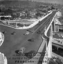 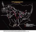 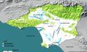 Date: 02/15/09 03:32 1938 L.A. Flood Facts Author: espeeboy Bruce Petty photos:
Photo 4: Opposite view of the first three views looking North at the SP L.A. River Bridge crossing. This was the when the worst flooding (and gravity) had taken out most girders and wood ties on the middle and western bridge sections. Photo 5: Rebuilding the bridge late 1938 photo showing the east side original girders left intact, new middle span and West span girders in place. The Bullring yard is behind the photographer, the UP mainline is to the right. Also notice the original washed away girders uncovered in the L.A. River mud bottom at the lower right. Photo 6: A 1939 photo looking North of Riverside Drive alongside Dayton Tower and Taylor Yard. It shows what widening and grading was done inside the River in a fairly short amount of time to control what the L.A. River might throw at the city during the next big storm season. Note that the concrete lined walls didn't go in until after 1941. Link to sine no-sound raw film (now video) and KOCE TV documentary "snapshot" teaser video of some of the 1938 flooding: http://www.youtube.com/watch?v=sAQ1gxYvvmw http://www.youtube.com/watch?v=WoZa5qUkU4Q A few more uploaded (non-RR) 1938 flood videos I found today: http://www.efootage.com/stock-footage/61436/1938-38-1930s-Thirties-los-angeles-flood-floods ~~~ Some additional info on the March 4, 1938 floods: - a combination of two back-to-back storms combined for over 10" of rainfall in less than 5 days - Feb 27-28, 1938, Storm #1 dumps 4.4 inches of rain - Mar 1- 3, 1938, Storm #2 dumps 6+ inches of rain - 115 people die - 5,601 homes destroyed - 1,500 homes severely damaged - 168 sq. miles of L.A. Basin or 15% of non-mountainous area under water - 20+ cabins washed away along the Arroyo Seco - the Navy battleship, USS Arizona sitting 7 miles offshore reports swept-out river wreckage in the Pacific drifted out by wind and tide - by the end of day March 3, 1938 all 14 L.A. Basin dams were full to the brim with water (but holding up) - most if not all structures along Tujunga Canyon were washed out - Big Tujunga "creek" water rushed out of the canyon at a flow rate of 40,000 cub. ft / sec (filling up Tujunga Dam and not running into the L.A. River) - for comparison, the L.A. River at its peak rushed out at 38,000 cub. ft / sec - due mostly to Santa Ana River levees breaking (water rose 5 ft in 30 seconds early March 3rd), 50% of Orange County was under water on March 4, 1938 - the Santa Ana River on March 2nd through Prado, CA (West Corona) recorded the strongest water currents of the flood at 100,000 cub. ft / sec!!! - most schools closed down for two days - so many Hollywood stars were stranded at their SF Valley ranches that the Academy Awards show scheduled at the downtown Biltmore Hotel was postponed for a week - hype-motivated radio reporters falsely described flood-related catastrophes that never took place (L.A. news media hasn't really changed) like Calabasas being completely "wiped off the map" - Los Angeles mayor Frank L. Shaw was formally recalled on September 16, 1938 after publicly declaring on the day of the floods that "the sun is shining in Southern California and all is well" as thousands lost their homes, dozens lost their lives - Congress passed the Flood Control Act of 1941 which authorized $257.4 mil to the US Army Corps of Engineers to build the Concrete L.A. River we all know and love today ~~~ 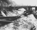 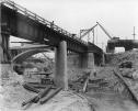 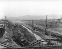 Date: 02/15/09 03:50 Re: 1938 L.A. Flood Facts Author: espeeboy Photo #7: Still 1939 back atop the Figueroa Street overpass looking South down river. The shared UP/SP ROW is on the left, the ATSF river crossing trestle is seen in the distance about a 1/4 mile down, Bullring Yard complete with steam engines visible on the right. (SP photo)
Photo #8: Pre-flood homes built right along the natural culvert L.A. River just South of Taylor Yard Diesel. Today Metrolink's Maintenance Facility ends here just past their Northern end locomotive servicing facilities where the realigned SP/UP mainline S-curves away from San Fernando following the L.A. River to the Diesel shop side of the former SP classification yard. Photo #9 Present day photo of the flooded Riverside Drive/Figueroa Street overpass area in all of these photos showing the present day 110 Pasadena freeway built up. The beefy double track "green bridge" was built in the early 90's to accommodate Metrolink movements replacing the post-flood 1939 era SP bridge. ~~~ 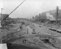 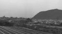 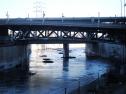 Date: 02/15/09 15:23 Re: 1938 L.A. Flood Facts Author: colehour The flood also washed out a practically brand new highway along the East Fork of the San Gabriel River in the San Gabriel Mountains. Many years ago I hiked along the old roadbed and came across the "Bridge to Nowhere," a lovely concrete bridge that spans one of the highest gorges in San Gabriels. You could still see remains of the road but the tunnel at the north end of the bridge had been dynamited by the Forest Service to avoid problems. One can only imagine the power of that flood.
Date: 02/15/09 16:30 Re: 1938 L.A. Flood Facts Author: scottp espeeboy Wrote:
------------------------------------------------------- > - the Navy destroyer, USS Arizona sitting 7 miles > offshore reports swept-out river wreckage in the > Pacific drifted out by wind and tide Battleship, not destroyer > > > - hype-motivated radio reporters falsely described > flood-related catastrophes that never took place > (L.A. news media hasn't really changed) like > Calabasas being completely "wiped off the map" > That wasn't Paul "Stormwatch" Moyer, was it? (As a kid, talking into a tin can on a string?) Date: 02/15/09 17:48 Re: 1938 L.A. Flood Facts Author: espeeboy scottp Wrote:
> > Battleship, not destroyer D-OH! Sorry, I knew that. ~~~ Date: 02/15/09 19:57 Re: 1938 L.A. Flood Facts Author: BCHellman espeeboy Wrote:
------------------------------------------------------- > > Photo 5: Rebuilding the bridge late 1938 photo > showing the east side original girders left > intact, new middle span and West span girders in > place. The Bullring yard is behind the > photographer, the UP mainline is to the right. > Also notice the original washed away girders > uncovered in the L.A. River mud bottom at the > lower right. > Am I missing something here, but it looks like the Highway bridge is gone over the tracks. Did it get knocked out by the storm? Date: 02/15/09 20:05 Re: 1938 Los Angeles Flood Author: BCHellman espeeboy Wrote:
> Last photo shows a close-up of the leftside East > riverbank wash-out of the old UP Glendale Branch > ROW as set up for SP trackage rights. By the looks > of the nice perfectly cut and aligned ties visible > after wash out and seeing the year is 1938, or 15 > months before L.A. Union Station opened up to the > public, I am pretty sure that the East bank double > track mainline had just been relaid by the SP / UP > in order to better streamline future SB SP > passenger trains arriving into the new station via > Possum Belly curve and Mission Tower. From May > 1939 on, inbound SP passenger trains from the > North (Coast or Valley lines) would no longer > cross the Bullring bridge L.A. River crossing > which lined up trains down Alameda to the old > street-running (or street-stopping?) Los Angeles > SP Passenger station. > This may be why D.J. Russell, Superintendent of the Los Angeles Division at the time, decided to single track the replacement bridge over the LA River instead of two tracks, because eventually all Coast and San Joaquin passenger trains would be using the East Bank. I'm assuming that during the rebuild all Coast and San Joaquin passenger trains accessed Central Station by detouring down the east bank, then crossing the LA River at Yuma Jct, and then down the Alameda. Must have been time consuming. Date: 02/15/09 22:34 Re: 1938 Los Angeles Flood Author: CimaScrambler And as bad as the 1938 flood was, the one in 1862 is said to have been 4 to five times larger. As I understand it, the 1862 flood had a similar senario: deep snow in the mountains followed by several days of intense warm rain. At the time of the 1862 flood, the JD Whitney California Geological Survey party was trying to cross the San Gabriel River near Azusa but had to wait several weeks for the water to recede sufficiently for crossing to be safe. The 1862 flood (or more accurately the weather that caused it) also affected the San Joaquin and Sacramento Valleys and was made famous in a couple of Brett Harte stories.
- Kit Kit Courter Menefee, CA LunarLight Photography |