| Home | Open Account | Help | 251 users online |
|
Member Login
Discussion
Media SharingHostingLibrarySite Info |
Nostalgia & History > Siskiyou Line- Buck Rock Tunnel(s)Date: 02/07/12 20:26 Siskiyou Line- Buck Rock Tunnel(s) Author: funnelfan First a little background on the Siskiyou Line. The Oregon & California RR was a state land grant railroad. Starting in Portland it built south before stalling out with the end of track in Roseburg. A second push to complete the line to the California State line before the grants expired got as far as Ashland. South of Ashland they surveyed a route that looped around Buck Rock on a 2.2% grade to Siskiyou Summit. The route crossed some rugged and steep terrain that would require multiple tunnels and tall bridges. Work was started on the tunnels along the route, namely the summit tunnel and Buck Rock Tunnel, the two longest tunnels of the route. The railroad failed to fullfill the charter of the land grant in time, and the land grant reverted to the state and became known as the O&C lands. It was in the midst of this that the railroad was scooped up by the SP. SP had already been building north in California to connect with the O&C. SP decided not to continued to the expensive grading of the O&C route and surveyed a new shorter line that had a 3.3% grade. The new line only shared the summit tunnel with the original route, and the summit tunnel became Tunnel 13 on the shorter route.
The half completed Buck Rock Tunnel has been known to hikers and history seekers for some time. The rock bore reaches deep into the side of Buck Rock and has drawn hikers and adventures seeking to find a little bit of forgotten history. As I've written about many times before, I'm looking at Lidar mapping to find abandoned grades in Oregon and Washington. So I found a little surprise when I went looking for Buck Rock Tunnel on the southern border of Oregon. I found not one tunnel, but three! Seems the tunnel rats completed two short bores before tackling the 1600' long Buck Rock Tunnel. I've never heard of the shorter bores, and it may be that they are known to a very few if any. I've included a map showing the unfinished route in relation to the current line (out of service at this time). The second image is the Lidar hillshade map that clearly shows the tunnels. Since the grade was not well developed, I marked it in red. Ted Curphey Ontario, OR 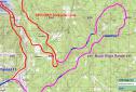 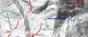 Date: 02/07/12 20:48 Re: Siskiyou Line- Buck Rock Tunnel(s) Author: rob_l Interesting. So the grade up to the first horseshoe is only 2.2%, and the 3.3% begins there?
Thanks in advance, Rob L. Date: 02/07/12 21:54 Re: Siskiyou Line- Buck Rock Tunnel(s) Author: SCAX3401 Is it possible there are no tunnels there but instead the construction grading crews simply dug the cuts to allow the tunneling crews a "vertical wall" to start drilling into when they got around to them? I don't know the answer and possibly the only way to know for sure is to hike out and look...but even then, any tunnel portals could have easily collapsed over time.
Date: 02/07/12 21:59 Re: Siskiyou Line- Buck Rock Tunnel(s) Author: funnelfan rob_l Wrote:
------------------------------------------------------- > Interesting. So the grade up to the first > horseshoe is only 2.2%, and the 3.3% begins > there? > > Thanks in advance, > > Rob L. I hadn't specifically looked at that. But reviewing some track charts, it appears the ruling grade is 2.2% from Ashland to MP 424 (5 miles south of Ashland), where the grade goes to 3%. The grade varies quite a bit ranging from 2.0% to 3.4% between 424 and the summit. I'd say that MP 424 is where the grade transitioned from the O&C route to the SP route. But's hard to say where the O&C intended to place it's route from MP 424 to the Dollarhide Curve. BTW the lower part of the Dollarhide Curve was a famous "S"-curve trestle before it was filled in 1917. Ted Curphey Ontario, OR Date: 02/07/12 22:23 Re: Siskiyou Line- Buck Rock Tunnel(s) Author: funnelfan BNSF6400 Wrote:
------------------------------------------------------- > Is it possible there are no tunnels there but > instead the construction grading crews simply dug > the cuts to allow the tunneling crews a "vertical > wall" to start drilling into when they got around > to them? I don't know the answer and possibly the > only way to know for sure is to hike out and > look...but even then, any tunnel portals could > have easily collapsed over time. Well you are correct in that it's hard to tell what the scene looks like on the ground. But I do have reason to believe that these were likely completed tunnels. Other than some wagon roads, no general grading was done on the route, only the tunnels were worked on. There also appears to be quite a bit of fill material placed outside of each tunnel portal which suggests that much of that came from inside the hill. The southern of the two tunnels appears that it's been subjected to a lot of settling. The northern tunnel appears largely intact though. Ted Curphey Ontario, OR Date: 02/08/12 07:29 Re: Siskiyou Line- Buck Rock Tunnel(s) Author: TonyJ Looks like I'll have to do some hiking this summer and see if I can find anything. Many years ago I hiked to where SP daylighted a very short tunnel north of Steinman. You could see where it once was. On the other hand finding the exact railroad locations are tough to find, such as Chavner Juction, where the Gold Hill Lumber & Railroad Company once connected.
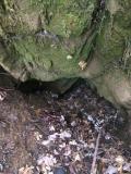
Date: 05/18/18 16:05 Re: Siskiyou Line- Buck Rock Tunnel(s) Author: ckduval I am an amateur explorer and caver. I found both portals to Buck Rock tunnel about 5 years ago with my boys and have explored it many times since. I had no knowledge of the two shorter bores until this article and have found no other information about them. Has anyone been up there since this thread was posted and found the shorter tunnels? I went up yesterday and located both ends of the northern tunnel. There is no access inside now if the tunnel is there. There is much erosion on both ends. However on the North end there is a small hole in the Rock that looks like it could be the last remnants of the tunnel opening. I have attached a picture. The trench leading to the North end is longer, there is much fallen timber in the base of the trench. It is very shaded from trees on both sides and cannot really be seen on the satellite images on Google maps. The southern end is sunnier with less trees and can be seen faintly on Google maps. The trench is shorter and any opening that may have existed is now eroded over. I plan to go back soon in search of whatever remains of the southern tunnel.
 |