| Home | Open Account | Help | 254 users online |
|
Member Login
Discussion
Media SharingHostingLibrarySite Info |
Nostalgia & History > Ocean Shore RR profile mapDate: 09/01/14 21:32 Ocean Shore RR profile map Author: fmaffei Part of Devils Slide Pacifica, CA. Circa 1916.
Scale: Vert. 1 inch = 20 ft Scale: Horz. 1 inch = 400 ft. 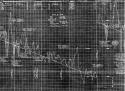 Date: 09/01/14 22:32 Re: Ocean Shore RR profile map Author: TonyJ I've never seen a Ocean Short track profile map until now. With Devil Slide in this map it could be substituted as a earthquake events recorder, or a EKG for the heart. In all cases it reflects the stress the Ocean Shore gave its stockholders.
Date: 09/02/14 16:02 Re: Ocean Shore RR profile map Author: doge_of_pocopson This seems to show the multiple short bridges and culverts that were part of Devil's Slide's track. Amazing feat. B
|