| Home | Open Account | Help | 351 users online |
|
Member Login
Discussion
Media SharingHostingLibrarySite Info |
Nostalgia & History > Stone Canyon & Pacific Rwy a.k.a Coal Fields RwyDate: 09/16/14 23:43 Stone Canyon & Pacific Rwy a.k.a Coal Fields Rwy Author: CA_Sou_MA_Agent Does anyone know if any of the abandoned right-of-way of the line described below is still visible and could possibly be covered with a four-wheel drive or other vehicle?
ANY current info on this line would be appreciated. Stone Canyon Mine, Monterey County, California A 21.5 mile shortline railroad of broad gauge, known initially as the Stone Canyon and Pacific, owned by Stone Canyon Consolidated Mines, was serviced from the junction with the Southern Pacific at McKay beginning in 1907. The railroad was routed up Indian Valley in southern Monterey County, then along Big Sandy Creek to the Stone Canyon Coal Mines high in the Cholame hills. The line climbed from an altitude of 500 feet at McKay Station to 1,800 feet at its terminus. The railroad crossed the Salinas River on a 30 foot high trestle. The entire line washed out during flooding in 1914, when an earthen dam above the mines overflowed, washing out 12 trestle crossings down Indian Valley. The wooden bridge at San Miguel also washed out in the 15 foot deep floodwaters, taking out the Stone Canyon Railroad trestle over the Salinas River as well, on its rush to Monterey Bay. The trestle was rebuilt with a 1,300 foot crossing in 1921, and new track was laid up the valley. After 1920 the line was known as the Coal Fields Railway an was operated as such until abandonment in 1932. The Railroad had one engine, an ex NYC 10-wheeler numbered 2288. Date: 09/17/14 09:21 Re: Stone Canyon & Pacific Rwy a.k.a Coal Fields Rwy Author: colehour I'd seen a reference to that on an old map, but have no idea what condition the old ROW might be in. When I lived in California I had intended to check it out, but never did.
There are some remnants of the former San Juan Pacific near Hollister, in San Benito Co., not too far from San Miguel. The last time I was through there (probably 14 years ago), there were still tracks in the pavement on one road. I think that its principal business was from a quarry, which had its own narrow gauge operation. Date: 09/17/14 12:29 Re: Stone Canyon & Pacific Rwy a.k.a Coal Fields Rwy Author: spnudge I was firing for George McCarron in the late 60s on the gang to Wat. Jct. He showed me where you could still see the coal railroad wye on a high fill, that headed for the river crossing. You could still see over where the old SP RofW was and where it used to cross the Salinas River. SP rebuilt that section and built the present steel bridge west of McCay.
I had a map, where it is I don't know, showing the track going almost all the way to Coalinga. Don't know what exists on the east side of the river. Nudge Date: 09/17/14 12:39 Re: Stone Canyon & Pacific Rwy a.k.a Coal Fields Rwy Author: billmeeker Date: 09/17/14 12:47 Re: Stone Canyon & Pacific Rwy a.k.a Coal Fields Rwy Author: hogheaded Western Railroader Issue 340 has an article about the RR. Don't know about the drive-ability of the ROW, though.
Date: 09/17/14 12:59 Re: Stone Canyon & Pacific Rwy a.k.a Coal Fields Rwy Author: BaltoJoey Looking at a 1919 and 1932 Topo map at the Historic Aerials
site. I see an Indian Valley & Stone Canyon Railroad on those maps. I did a Google for Stone Canyon Railroad and found a thread on that road here at Trainorders dated 2006. That thread gives a little more information about that line. http://www.trainorders.com/discussion/read.php?11,1201167 BaltoJoey Date: 01/08/17 12:25 Re: Stone Canyon & Pacific Rwy a.k.a Coal Fields Rwy Author: hogheaded Better WAY late, than never. This photo just turned up in a pile. Presumably it was taken after the line quit.
EO 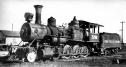 |