| Home | Open Account | Help | 398 users online |
|
Member Login
Discussion
Media SharingHostingLibrarySite Info |
Nostalgia & History > Oakland-1st Street & the Bridges of San Antonio CreekDate: 10/22/14 16:25 Oakland-1st Street & the Bridges of San Antonio Creek Author: KeyRouteKen Hi Everybody--
Evan Werkema has attempted to "explaineth" operations on Oakland's "1st Street" and its environs for mainline trains and local trains/streetcars.. Here's a snapshot story about the nearby Bridges. The Webster St Bridge and the Harrison St Bridge, prior to construction of the Posey Tube: Webster Street Bridge The Webster Street Bridge (1871–1928) was a swing bridge over San Antonio creek, between Oakland and Alameda. It was used until the opening of the Posey Tube. The original Webster Street Bridge was 1000 feet long, with a draw span of 200 feet, and was completed early in March, 1871 at a cost of $25,000, shared jointly by Oakland and Alameda; it remained in service until 1898, when the federal government ordered it to be replaced by a larger and more modern design. On May 30, 1890 the bridge was the site of the Webster Street Bridge disaster, a tragic railroad train accident which killed 13 passengers. On January 30, 1898, John Raddich was walking across the bridge and was struck and killed by a passing train. In 1912, the bridge tenders complained to the board of supervisors that many "autoists" (automobile drivers) were failing to stop for the warning gates. On January 7, 1926, the bridge’s central span was hit by the steamer Lancaster and destroyed. Even though the Posey Tube was by then under construction, the bridge was rebuilt – only to be sold two years later to Sacramento County: “On November 30, 1928, just one month after the opening of the Posey Tube, Alameda County auctioned the Webster Street Bridge, (980 feet long, steel, swing-span rim-bearing type, cantilever construction) to Sacramento County for just $3,100. The bridge had been erected just 2 years earlier at a cost of $134,000.” ”While the tube was being built, a ship rammed into the Webster Street bridge and caused it severe damage, making it unusable. With no crossing at Webster Street, the merchants along Webster Street suffered an immense loss in business — and so the Webster Street Bridge was rebuilt — even as the tube was being constructed.” The second photo shows the TWO parallel bridges. -------------------------------------------- March 23, 1923 the War Department issues a permit to the Board of Supervisors of Alameda County to construct a tunnel under the Alameda-Oakland estuary. The Harrison St Bridge and Webster St Bridge are ordered to be removed. -------------------------------------------- Oakland via Alameda Pier Line (originally South Pacific Coast Railroad - steam line) - 14th and Franklin Station, via Webster, Harrison St bridge, to private right-of-way to Alameda Pier. Terminated December, 1923. Crosstown Streetcar Line - Oakland 16th St Station, via 18th St, then via diagonal private right-of-way to West St to 20th (alternating with 21st) to Franklin, through 14th and Franklin Station to Webster St to Harrison St bridge to private right-of-way to Mastick (Alameda) to 8th to Central to Encinal to Fernside to private right-of-way to Lincoln to Mastick and back. Alternate cars went around the Alameda loop in the opposite direction. Some service was to 14th and Franklin only. In December, 1923, all service was cut back to the 14th and Franklin station. Terminated March, 1926. ------------------------------------------------------ The Webster Street Bridge was used for Autos, Trucks and Key System streetcars... The Harrison Street Bridge was used for SP Dinkeys (streetcars) as well as mainline/branchline STEAM trains to Alameda.. Cheers. KRK (2 days left to work--Hooray!!) 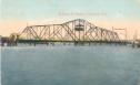 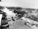 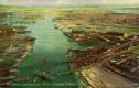 Date: 10/22/14 20:34 Re: Oakland-1st Street & the Bridges of San Antonio Cre Author: TCnR Interesting to see the dredge working in #2.
Congrats on retirement. Date: 10/22/14 23:15 Re: Oakland-1st Street & the Bridges of San Antonio Cre Author: Thomas Another bridge view (complete with dredge!), plus a 1915 map…
Edited 1 time(s). Last edit at 10/22/14 23:16 by Thomas. 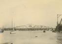 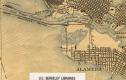 Date: 10/22/14 23:36 Here's a map Author: stash Here's a map of the tidal canal and adjoining area.
The Webster Street draw bridge had numerous vessel strikes. Amazing it lasted as long as it did. On top of that, the span was open many hours of the day for ship traffic along with the adjacent SP bridge. Thank God the Posey Tube was constructed. A parallel tube was built in the '60s known as the Webster Street tube. Alameda has never been an easy place to access. That's part of its charm. 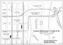 |