| Home | Open Account | Help | 333 users online |
|
Member Login
Discussion
Media SharingHostingLibrarySite Info |
Nostalgia & History > Help with this SD&AE pic west of El Centro, CA 1970Date: 10/25/14 10:02 Help with this SD&AE pic west of El Centro, CA 1970 Author: the_expediter In early to mid Nov. 1970, I had the LUCK to ride SD&AE daily freight number 452 from San Ysidro (border of San Diego-Tijuana, MX) to El Centro with a now passed friend and employee. This pic was somewhere between Plaster City and El Centro...prob. around Seeley. I was in the cupola when suddenly I spotted this train (dead?) with an SW on point and atleast 4 cars backed into a spur, off to the north of the east-west mainline. I quickly (with the agility of a cat) turned and shot this...looking into the sun w the light meter going nuts! Any former employees out there that worked around El Centro in those days know what train this is? It has a 40' tankcar with it...doesn't look like the Plaster city job due to the cars that I see in this shot...no bulkhead flats. Thanks for any help...Thank God I shot it, into the sun and thinking it would be a crap pic!...Now, 44 years later, hardly anything on the SD&AE is posted here...I posted this as a very tough where-is-it 10 yrs ago...Southlandwarrior got it after many guesses, looks like he's no longer on this site under that name, anyway....Steve in Grossmont, CA...10 years older but not a day wiser...Hee Hee
Edited 1 time(s). Last edit at 10/25/14 10:06 by the_expediter.  Date: 10/25/14 10:17 Re: Help with this SD&AE pic west of El Centro, CA 1970 Author: callum_out The Seeley siding (with the beet loader) didn't look like that. Wasn't there a
siding into the base at one point?" Out Date: 10/25/14 10:34 Re: Help with this SD&AE pic west of El Centro, CA 1970 Author: 2720 Looking at my SD&AE SPINS book, it looks like you are passing
the spur into the 3 D Cattle Co. Spur number 0816. Black arrow pointing at the location. This is located just east of Seeley, right around MP 140.8. This is the only location that seems to match your photo, I have attached the SPINS book page showing the track layout. Mike I added a section of my SD&AE Track Chart showing this same location, its outlined by the square box. Edited 1 time(s). Last edit at 10/25/14 11:07 by 2720. 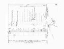 Date: 10/25/14 11:17 Re: Help with this SD&AE pic west of El Centro, CA 1970 Author: the_expediter Thx to you both...I think Mike nailed the location...This was on a Saturday I remember...maybe this was a local that worked the industries west of El Centro...Where would they build the #451 westbound? 28 or 38 track? That train musta left El Centro quite a bit later than eastbound, we met at Coyote Wells I remember...-Steve
Date: 10/25/14 14:52 Re: Help with this SD&AE pic west of El Centro, CA 1970 Author: callum_out 0825 would have been the beet loader, neat map, thanks for the clarification.
The siding in question doesn't seem to be there anymore. Shot is at Seeley looking West toward the siding(s) location. Out  Date: 10/25/14 16:17 Re: Help with this SD&AE pic west of El Centro, CA 1970 Author: 2720 callum_out Wrote:
------------------------------------------------------- > 0825 would have been the beet loader, neat map, > thanks for the clarification. > The siding in question doesn't seem to be there > anymore. Shot is at Seeley looking > West toward the siding(s) location. > > Out This is where Carrizo Gorge Railway interchanged with UP. I made a lot of trips here picking up loads and dropping off empties! Because of changes to the main and sidings at Plaster City, there was no room to interchange there, except if we just had empties to send out. We would shove 8 miles from Coyote Wells and couple the empties to the outbound loads from the gypsum plant! Mike Date: 10/25/14 17:16 Re: Help with this SD&AE pic west of El Centro, CA 1970 Author: callum_out Beautiful Plaster City where this thing lived!
Out 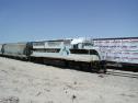 Date: 10/25/14 17:28 Re: Help with this SD&AE pic west of El Centro, CA 1970 Author: 2720 callum_out Wrote:
------------------------------------------------------- > Beautiful Plaster City where this thing lived! > > Out The owner of this GP40 does the switching for all the US Gypsum plants around the United States. They do all the standard guage switching around the Plaster City plant. US Gypsum has their own crews operating the narrow guage! A couple of us did an inspection and filter change on this locomotive a few years ago, as well as some minor repairs to it and a GP9 backup unit! Mike Date: 10/25/14 18:51 Re: Help with this SD&AE pic west of El Centro, CA 1970 Author: MyfordBrowning A very interesting photo location. The location just east of Seeley is the only location that seems correct as identified by Mike. I was a bit confused by the way the SPIIN chart showed the location since it went from east to west while the track chart was the more common west to east (l to r).
It is interesting that the spur tracks do not appear on Topo maps surveyed in 1958 and reprinted, and I assume updated, through 1990. Current topo maps omit railroads completely. Aerial photo of Seeley in the late 1990s and early 2000s show no trace of the spurs. I wonder if these spur track were originally constructed to serve as team tracks for the Naval Air Station ? Steve, keep the SD&AE and San Diego stuff coming. Cliff Date: 10/25/14 19:07 Re: Help with this SD&AE pic west of El Centro, CA 1970 Author: callum_out Cliff, that was my thought as well, the base did use rail service for a time, those
spurs from their appearance looked to be set up for end or "circus" loading. Out Date: 10/26/14 12:18 Re: Help with this SD&AE pic west of El Centro, CA 1970 Author: MyfordBrowning I found a 1981 SPIN for El Centro - Plaster City line and the spurs were shown as serving Desert Seed Company at the time. All the switches involving the spurs were marked as spiked which seemed to indicate that the spurs were out of service. The spur tracks were all short with 2-3 car capacity. There was one spot labeled for tank cars and the ends of two were labeled "Pitt" (a ramp or pit ?). The other spots were open areas.
Cliff Date: 04/07/15 15:00 Re: Help with this SD&AE pic west of El Centro, CA 1970 Author: SP4810 An engineer friend of mine told me some years back that these spurs were abandoned after
Hurricane Kathleen tore thru the valley in 1976. |