| Home | Open Account | Help | 365 users online |
|
Member Login
Discussion
Media SharingHostingLibrarySite Info |
Nostalgia & History > Necrophoaming the SN #13Date: 11/23/14 14:38 Necrophoaming the SN #13 Author: BoilingMan SN 13
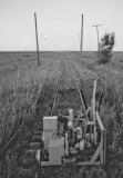
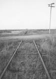
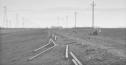
Dozier, the Vacaville Branch, and on to Bunker. Dozier is where the Vacaville Branch took off after Travis Air Base was built. The branch went a little over 7mi to where it crossed over the Southern Pacific and split again to go on to Vacaville and Susuin. Later still, when the SN mainline was cut off from Sacramento, a connection to the SP was put in at Cannon so that this section of the line could be served using SP trackage rights. Photo 1. MP 64.55. Dozier. This view is much like the one at Creed: Sac to the left and SF to the right with the branch passing under us. The roadway in the photo is CA 113. I shot this in January 1990, 8 months after the wye had been removed. But rail had been left in between Cannon, on the SP, and the RR museum at Rio Vista Jct. Photo 2. Apx MP 7.25 (or 72ish from SF) Pencils up- we pause for a story. In the Spring of 1989 the UP (I guess) started pulling up SN track. What was left of the main line east of Dozier and the Vacaville Branch were literally disappearing over night. As I mentioned above, the connection to the Museum stayed, but at the moment I wasn't sure even THAT would survive. Soooooo... one rainy afternoon I trailered my Fairmont out for a last fling while there was still something to, um, flung. There was something, I can't remember what, that I wanted a photo of at the SN bridge over the SP near Cannon. But because of the rain I hadn't taken my camera along. So about 4 or 5 days later I came back to shoot whatever it was, AND THE TRACK WAS GONE! I posed the Land-Rover on the bridge where I'd paused with my Fairmont only days before for a sad portrait. But here's the thing: The very last rail traffic over this SN bridge was an SN car- my little M-19, SN M-51. Cool. Photo 3. Dozier. Looking towards Sacramento. This is the Mainline part of the Dozier wye. The truck is crossing on Highway 113. The rail had only been pulled days before. Photo 4. MP 67.75. Vale. Here I caught up to one of the machines o' destruction. Note the catenary poles. For some reason the poles still standing tended to be in places where there had been switches- I wonder why? Photo 5. Apx MP 68.25. The grade crossing is Maine Prairie Road. The rail beyond the road is gone. Photo 6. Apx MP 70. Bunker. SR Bush Dutch Flat 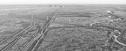 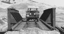 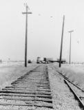 Date: 11/23/14 14:40 Re: Necrophoaming the SN #13 Author: BoilingMan cont
   Date: 11/23/14 17:12 Re: Necrophoaming the SN #13 Author: switchlamp Thanks again , I look forward to mre,
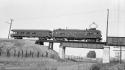
Tom Date: 11/23/14 17:31 Re: Necrophoaming the SN #13 Author: wharfrat A great series, I too have motored over this bridge. A before photo of a BAERA trip for comparison.
 Date: 11/23/14 17:44 Re: Necrophoaming the SN #13 Author: BoilingMan Nice. Much nicer than how I did it.
(I can't remember how I got the Land-Rover up there!) BTW: This bridge has since been removed entirely. It spanned both the road you see and the SP just off to the right. Trivia: I work the Capitol Corridor trains, and the Coast Starlight before that. I did some rough math- I've passed under this bridge (real, and then later remembered) apx 9,500 times- Holy Crap! SR Edited 1 time(s). Last edit at 11/23/14 18:03 by BoilingMan. Date: 11/23/14 21:25 Re: Necrophoaming the SN #13 Author: KeyRouteKen Regarding DOZIER (named after Melville Dozier):
http://freepages.genealogy.rootsweb.ancestry.com/~npmelton/sacdozi.htm Dozier (MP 64.55) Site of a wye built in 1946 by the Federal government on behalf of the Sacramento Northern Railway to compensate for the elimination of the Railway’s wye at Creed to allow for expansion at nearby Travis Air Force Base. A 697’ spur, substation, freight dock and several other small line side structures were at the site. From this point Sacramento Northern trains ran north and west. The wye was partially removed in 1993. None of the structures remain. KRK Edited 1 time(s). Last edit at 11/23/14 21:34 by KeyRouteKen. Date: 11/23/14 21:46 Re: Necrophoaming the SN #13 Author: BoilingMan Hi Ken
I'm quite sure of the dates on my photos. I shot the aerial of Dozier in Jan 1990 and the Dozier Wye is already the Dozier Curve. Just say'n.. SR Date: 11/24/14 07:00 Re: Necrophoaming the SN #13 Author: KeyRouteKen BoilingMan Wrote:
------------------------------------------------------- > Hi Ken > I'm quite sure of the dates on my photos. I shot > the aerial of Dozier in Jan 1990 and the Dozier > Wye is already the Dozier Curve. > Just say'n.. > SR Any info I post on your threads of the SN, including DATES, is coming from official government documents provided through the courtesy of the Western Railway Museum. What say thou ? KRK Date: 11/24/14 07:43 Re: Necrophoaming the SN #13 Author: BoilingMan I dunno...
I took all of my photos in 1989, and into 1990. All show Dozier as dismantled. I was sharing my work with Vernon Sappers up until the earthquake in Oct 1989, so there's no mistaking the time frame. My guess would be that 1993 might be when the UP had finished all their dismantling work and filed something that included a list of what had been done, including to work at Dozier. That would hang a '93 date on it and unless you looked closer you'd accept it as meaning everything happened at once. Just a guess. SR Date: 11/24/14 08:43 Re: Necrophoaming the SN #13 Author: stash Not all official government documents are accurate. They are, after all, prepared by human beings.
KeyRouteKen Wrote: ------------------------------------------------------- > BoilingMan Wrote: > -------------------------------------------------- > ----- > > Hi Ken > > I'm quite sure of the dates on my photos. I > shot > > the aerial of Dozier in Jan 1990 and the Dozier > > Wye is already the Dozier Curve. > > Just say'n.. > > SR > > Any info I post on your threads of the SN, > including DATES, is coming from official > government documents provided through the courtesy > of the Western Railway Museum. What say thou ? > > KRK Date: 11/24/14 13:32 Re: Necrophoaming the SN #13 Author: callum_out I went to work in Sacramento in 1992 and the Holland portion I do believe was still in place.
Out Date: 11/26/14 08:49 Re: Necrophoaming the SN #13 Author: CCT41 SR, will you be covering the Holland Branch towards Oxford and Valdez?
Date: 11/26/14 10:32 Re: Necrophoaming the SN #13 Author: BoilingMan Not really, or rather, not that far. I only went as far as the sugar plant at Clarksburg.
As I've said (sorry for the repetition) what I'm posting here was an abandoned project. To make it work I felt I needed the help of Vernon Sappers or the Western Railway Museum, someone/place like that for vintage images to compliment what I was doing, but no one was interested- so eventually I just sort of let it go. As a result I never fully explored the Holland. SR Date: 11/26/14 13:52 Re: Necrophoaming the SN #13 Author: CCT41 That is too bad, I have been looking high and low for SN photos on the Oxford branch. I did just find my slides of the sub station at Valdez.
BoilingMan Wrote: ------------------------------------------------------- > Not really, or rather, not that far. I only went > as far as the sugar plant at Clarksburg. > As I've said (sorry for the repetition) what I'm > posting here was an abandoned project. To make it > work I felt I needed the help of Vernon Sappers or > the Western Railway Museum, someone/place like > that for vintage images to compliment what I was > doing, but no one was interested- so eventually I > just sort of let it go. As a result I never fully > explored the Holland. > SR |