| Home | Open Account | Help | 271 users online |
|
Member Login
Discussion
Media SharingHostingLibrarySite Info |
Nostalgia & History > Robert Hanft: SP Newcomb Ave. station, 1950'sDate: 08/04/15 00:08 Robert Hanft: SP Newcomb Ave. station, 1950's Author: Evan_Werkema A recent thread over on the Western Board mentioned the upcoming removal of the former SP bridge over Quint St. in San Francisco, CA:
http://www.trainorders.com/discussion/read.php?1,3807299 atsf19455 included a link to a photo on Historypin showing the area in 1907, where the waiting shelter had "14th Avenue" on the roof: http://www.historypin.org/attach/uid55632/map/index/#!/geo:37.737186,-122.394903/zoom:20/dialog:255168/tab:preview/ I wanted to share this Robert Hanft photo from the Western Railway Museum Archives showing eastbound SP commuter train 120 from some time in the early 50's looking north from the Oakdale Ave. bridge. The shelter by that time had "Newcomb Ave." on its roof. I don't know when the names changed, but comparing a modern street map to this 1900 Sanborn index map for that area of San Francisco (seven years before SP built the Bayshore Cutoff) indicates that present day Quint St. was Q St. in 1900, Newcomb Ave. was 14th, and Oakdale Ave. was 15th. The area of the photo is about where the number 600 is on the map, and Hanft's view looks toward the bottom right of the map (northeast). http://www.historicmapworks.com/Map/US/217588/Index+Map+1/San+Francisco+1900+Vol+5/California/ It's also interesting that the main line tracks between Quint and Army St. (now Cesar E. Chavez St.) are still supported by trestlework in Hanft's view. Note also the derail on the lead to the left that would keep cars from running away uphill and fouling the main. ;^) 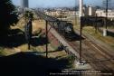 Date: 08/04/15 00:19 Re: Robert Hanft: SP Newcomb Ave. station, 1950's Author: Westbound This photo is like an ideal version of the SP, with the colorful floral bushes next to the mainline. Nothing like a 4-8-2 taking care of business!
Date: 08/04/15 01:10 Re: Robert Hanft: SP Newcomb Ave. station, 1950's Author: atsf19455 Great photo. Here's a ph tobob photo showing the scene in early 60's but from other side of tracks: http://www.trainorders.com/discussion/read.php?11,3749756,3749806#msg-3749806
The Hanftt raises some questions: 1. what was the shack near the bridge? 2. Was Newcomb a commute stop at the time of this photo? 3. When was the 14th Ave. lead built? 4. When was 14th Ave. last used? 5. Were there steps up to the platform when the 14th Ave. lead was put in and the grade for these be seen in the photobob photo just to the left of the pad for the hut/shleter that is in the Hanftt photo? 6. Why was there a concrete phone booth there? Is it still there hiding in the bushes? Date: 08/04/15 01:23 Re: Robert Hanft: SP Newcomb Ave. station, 1950's Author: atsf19455 Here's a posting by stash showing a 1948 John Harder photo of Newcomb stop looking toward the passenger shelter. http://www.trainorders.com/discussion/read.php?11,967725,967727#msg-967727
Edited 1 time(s). Last edit at 08/04/15 01:23 by atsf19455. Date: 08/04/15 04:57 Re: Robert Hanft: SP Newcomb Ave. station, 1950's Author: hogheaded According to late Engineer Bob Bonjiorno, the trestle seen here caught fire (I don't recall the date, but later in the Fifties, I guess), and rather than rebuild it, SP hauled-in fill. Soon after, "The Viaduct" - as the filled-in trestle was henceforth called - began to sink in spots, because the fire was not fully extinguished when it was covered up. He said that this went on for several months.
As for the 14th Ave. lead, I don't believe it was in use when the state unloaded Caltrain on the counties in 1992, but the tracks remained in place until after the century's turn, I think. As for the photo itself, it's a stunner - the palm tree and all of that floral green; Bay Bridge in the background and even a ship in the Islais Creek estuary. Cool, Evan! EO Date: 08/04/15 09:52 Re: Robert Hanft: SP Newcomb Ave. station, 1950's Author: EtoinShrdlu >The shelter by that time had "Newcomb Ave." on its roof. I don't know when the names changed,
There was an article in the SF Chron several months ago, and ISTR that the name changes happened either shortly before or after WWI. At any rate, the SF switchmen referred to the district as "14th Ave" to the end (1980s). The Quint St side was just "Quint St." (and AT&SF trackage). >3. When was the 14th Ave. lead built? Probably in the WWI era or shortly before. The whole area had been a US Army arsenal of some kind. The WP also served the area via the former Ocean Shore trackage along Army St. >6. Why was there a concrete phone booth there? Is it still there hiding in the bushes? To call 4th St Tower for entering the main lines. It had a pony phone (magneto) and could be difficult to hear the tower operator, particularly Derail Annie. >atsf19455 included a link to a photo on Historypin showing the area in 1907, where the waiting shelter had "14th Avenue" on the roof: The building in Bob Hanft's pic is the one five cars back in atsf19455's pic, and the absence of doors on the Necomb Ave building leads me to believe that Bob's building isn't (or no longer is) a waiting shelter but a M/W building of some sort. Date: 08/04/15 10:02 Re: Robert Hanft: SP Newcomb Ave. station, 1950's Author: EtoinShrdlu The building in front of gas holder is Grossgean's rice mill (speling ?). I also notice the City paving plant hasn't yet been built across Quint St from the sewage treatment plant, and there's a ship tied up in Islais Creek (prossibly unloading palm oil).
Date: 08/04/15 12:36 Re: Robert Hanft: SP Newcomb Ave. station, 1950's Author: BCHellman Subject: Newcomb Ave. In Service Dates and Other Relevant Information.
Date: 08/04/15 12:36 Re: Robert Hanft: SP Newcomb Ave. station, 1950's Author: atsf19455 Etoin thx for fielding the questions. The historypin.org collection shows that 14th Ave. lead was not built before 1923. I will check the CDNC for article on the marine arsenal being built.
Do you know what customers were on this lead? Did the produce market area get reefers or anything food-related? I wonder how good a customer the marine arsenal was. Date: 08/04/15 12:46 Re: Robert Hanft: SP Newcomb Ave. station, 1950's Author: atsf19455 To the left of the phone booth is a fence. I think that is a fence closing off McKinnon which used to run through there to Quint.
Date: 08/04/15 12:54 Re: Robert Hanft: SP Newcomb Ave. station, 1950's Author: johnsweetser > 1. what was the shack near the bridge?
Looks like a speeder shed. Date: 08/04/15 16:27 Re: Robert Hanft: SP Newcomb Ave. station, 1950's Author: mococomike The tracks on the left went down to then new produce terminal that replaced the old produce terminal where the Embacardeo towers now stand. This photo also shows a ship at the copra plier in the distance too.
Edited 1 time(s). Last edit at 08/04/15 16:31 by mococomike. Date: 08/04/15 18:25 Re: Robert Hanft: SP Newcomb Ave. station, 1950's Author: Evan_Werkema EtoinShrdlu Wrote:
> >atsf19455 included a link to a photo on > Historypin showing the area in 1907, where the > waiting shelter had "14th Avenue" on the roof: > > The building in Bob Hanft's pic is the one five > cars back in atsf19455's pic, and the absence of > doors on the Necomb Ave building leads me to > believe that Bob's building isn't (or no longer > is) a waiting shelter but a M/W building of some > sort. I think you're right that it's no longer a waiting shelter, but I suspect the building with "14th Avenue" on the roof is the same building in the same location as the one with "Newcomb Ave." on the roof. In both photos, the structure is immediately opposite the switch for the lead that drops down to Quint St. on the right. The 1948 photo from John Harder's collection shows a door on the track side of the shelter that wouldn't be visible in either Hanft's shot or the "14th Avenue" shot. atsf19455 wrote: > To the left of the phone booth is a fence. I think that is a fence closing off McKinnon which used to run through there to Quint. Aerial photos of the area show McKinnon to be essentially in alignment with the "eastern" abutment of the Quint St. bridge. The 1946 aerial on historicaerials.com suggests that McKinnon may even have been a through street for a while after the Bayshore Cutoff was built, passing under the bridge and intersecting Quint St. The fence to the left of the concrete phone booth in Hanft's shot is more likely closing off Newcomb Ave. Date: 08/04/15 19:43 Re: Robert Hanft: SP Newcomb Ave. station, 1950's Author: EtoinShrdlu >Do you know what customers were on this lead?
Got out my trusty old 1969 SPINS book, and this was Zone 3, with 40 spurs, one of which was listed as being out of service. Two of them were on Kirkwood Ave for the produce terminal.The lead (drill actually, but I never heard the term used by the old timers) ended adjacent to Newcomb Ave, and could easily have been connected to one of the two leads parallel to the main lines, but it was never done. Speling correction : C. E. Grosjean Rice (mill). The WP connected somewhere in the vicinity of Toland and Napoleon Sts. >Did the produce market area get reefers or anything food-related? Not in the era I worked there (1969-1974). >To the left of the phone booth is a fence. I think that is a fence closing off McKinnon which used to run through there to Quint. Probably dates from when the sewage plant was built. When it was expanded (c1980) it cause the rerouting of the Quint St lead through Circosta's scrapyard (one fine night we sent the clearance car to meet its torch there). Date: 08/04/15 21:40 Re: Robert Hanft: SP Newcomb Ave. station, 1950's Author: atsf19455 Thx Etoin for getting out the SPINS.
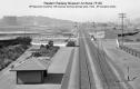
1. Are the shelters the same building in the 1923 pics as the HAnft pic? I think it's the same building in the Hanft pic and the 1923 pic. First of all they look exactly the same. Second, check out the station garden in the 1923 pic. Looks like you can see palm trees in there. Maybe not. But in any event, the station garden runs parallel to track on a line with the shelter. And in the HAnft pic the adult palm is on line with this line along wiht the shelter. Of course the garden is gone thx to the cut for the 14th Ave. lead. But it looks like that palm tree is a relic of the garden that wasn't torn out. 2. That fence in the HAnft pic that could be McKinnon Well, that fence and the wooden structure/barn just north of it appears in the 1923 photo too. So, if that's a street that's fenced off, it was fenced off in 1923. It looks like McKinnon is beyond that wooden structure/barn. Here's 1923 photo of McKinnon from the Quint St. bridge for reference: https://www.historypin.org/attach/uid55632/map/index/#!/geo:37.739366,-122.394542/zoom:20/dialog:255180/tab:details/ In this photo I guess thats McKinnon running past Miller and Lux to the east. And the Miller and Lux building is the same wooden structure/barn that is seen in the Hanfft photo in front of the smokestack and next to the fence in question. But it's a weird view to visualize because there is no street there today. So I guess the fenced off street, if it is a street, must be Newcomb. Edited 2 time(s). Last edit at 08/04/15 22:56 by atsf19455. Date: 08/05/15 00:33 Re: Robert Hanft: SP Newcomb Ave. station, 1950's Author: atsf19455 HEre's a great pic of the 14th Ave lead at http://wx4.org/to/foam/sp/san_fran/sp1227.html
Shows a switch engine on the 14th Avenue lead waiting to get on the main. The note to the photo calls these tracks the "300 lead". He also says Newcomb Avenue was a commute stop from 1941 to 1954. From the building to the right of the engine you can see that this photo was taken on the ramp south of Quint St. Attached is a look up the lead from Quint this year.  Date: 08/05/15 10:24 Re: Newcomb Ave. Author: timz One train a day stopped at Newcomb Ave in 1951-52;
no trains shown stopping in 1954 but train 72 would stop at Any Station for passengers from #9 and Newcomb Ave was still a station. Date: 08/05/15 10:46 Re: Newcomb Ave. Author: Evan_Werkema Here, for your dancing and listening pleasure, is a larger and lighter version of the 1923 valuation photo of 14th Avenue from the Western Railway Museum Archives. The negative itself is 8x10 and sharp as a tack.
 Date: 08/05/15 11:37 Re: 14th Ave. Author: timz Anyone explain that white fence next to the track,
like a cattle guard? Date: 08/05/15 11:58 Re: 14th Ave. Author: WAF Not much industry or trash
|