| Home | Open Account | Help | 334 users online |
|
Member Login
Discussion
Media SharingHostingLibrarySite Info |
Nostalgia & History > Mystery PhotoDate: 10/07/15 17:10 Mystery Photo Author: KeyRouteKen Ok folks-- where do you think these abandoned tracks might possibly be located ?? I'll give you three locations-same row !
KRK 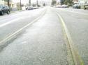 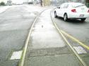 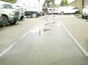 Date: 10/07/15 17:22 Re: Mystery Photo Author: Westbound Sure looks like SP's old Stonehurst Branch on 105th Ave., Oakland, CA.
If I'm right, it's only fair to mention moving from that street back in 1946. (Call me a Senior Citizen !) Date: 10/07/15 17:35 Re: Mystery Photo Author: LarryB I agree. On the corner of E 14th Street, across from Wise Oldsmobile, was a restaurant called "Antonio's". Not there anmore , but they had the absolute best steaks and fried zuchini anywhere. John Harder would remember it. Was this the old line that went to the long-gone GM plant?
Edited 1 time(s). Last edit at 10/07/15 17:43 by LarryB. Date: 10/07/15 18:20 Re: Mystery Photo Author: KeyRouteKen You're just too good, Gary. Yep- good 'ol 105th Ave. There was a Wig Wag where it crossed East 14th Street. The GM Truck Plant was right there. The right-of-way snuck between the backyards and tied into the double track main on Bancroft. I rode that route twice on a passenger train. 1954--1956 ; Steam powered too.
KRK Westbound Wrote: ------------------------------------------------------- > Sure looks like SP's old Stonehurst Branch on > 105th Ave., Oakland, CA. > > If I'm right, it's only fair to mention moving > from that street back in 1946. (Call me a Senior > Citizen !) Date: 10/07/15 18:22 Re: Mystery Photo Author: KeyRouteKen Yes, Sir Larry. You guys are good. Those tracks are still there.
KRK LarryB Wrote: ------------------------------------------------------- > I agree. On the corner of E 14th Street, across > from Wise Oldsmobile, was a restaurant called > "Antonio's". Not there anmore , but they had the > absolute best steaks and fried zuchini anywhere. > John Harder would remember it. Was this the old > line that went to the long-gone GM plant? Date: 10/07/15 18:52 Re: Mystery Photo Author: lwilton What is that in picture 2? A street running switch for a straight track that is no longer there? Or something else completely?
Date: 10/07/15 19:49 Re: Mystery Photo Author: KeyRouteKen Not sure what those two metal plates are for, Loren.
KRK lwilton Wrote: ------------------------------------------------------- > What is that in picture 2? A street running switch > for a straight track that is no longer there? Or > something else completely? > > Date: 10/07/15 19:56 Re: Mystery Photo Author: EtoinShrdlu >What is that in picture 2? A street running switch for a straight track that is no longer there?
Nope. View is taken looking west on 105th; the track is curving over to the W Oak - Niles line, where it jointed it a Elmhurst. This was rearranged in the 1990s to be and extension of the drill track (the lead on the land side of the WP main line). >Not sure what those two metal plates are for, Loren. Something to do with the crossing signals, such as they were. Date: 10/07/15 21:33 Re: Mystery Photo Author: TonyJ Others on this list beat me to the answer. However, I'll attach a few images I took of the Stonehurst Branch exactly 30 years ago.
Photo #1 - Up until 1982 the Branch left the SP main around milepost 13.4 at Elhhurst. These three photos show the old connection after abandonement. A little difficult to see here is where the switch used to be. It used to be shere the truck closes to the camera is. Photo #2 - The branch curved from the mainline to 105th Avenue. There are ties still in the roadbed. Photo #3 - In this view you can see where the branch reached 105th Avenue. 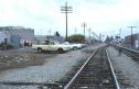 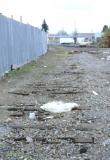 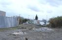 Date: 10/07/15 21:39 Re: Mystery Photo Author: TonyJ Photo #4 - After SP received trackage rights over the UP, trains used the switch at left to reach 105th Avenue.
Photo #5 - Moving to the end of the Stonehurst Branch this is how it looked looking back down (West) towards 105th Ave. Photo #6 - The track curved into the area where the old GM plant used to be. Edited 1 time(s). Last edit at 10/08/15 05:26 by TonyJ. 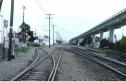  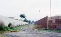 Date: 10/08/15 00:27 Re: Mystery Photo Author: Evan_Werkema TonyJ Wrote:
> Photo #4 - After SP received trackage rights over > the UP, trains used the xwitch at left to reach > 105th Avenue. This is looking southeast at 98th Ave., right? I had been under the impression that the track all the way to the right was WP's, but the one to the left that you're almost standing on was an SP drill track that paralleled the WP all the way down from Melrose. Was that not the case? Date: 10/08/15 05:38 Re: Mystery Photo Author: TonyJ Evan_Werkema Wrote:
------------------------------------------------------- > TonyJ Wrote: > > > Photo #4 - After SP received trackage rights > over > > the UP, trains used the xwitch at left to reach > > 105th Avenue. > > This is looking southeast at 98th Ave., right? I > had been under the impression that the track all > the way to the right was WP's, but the one to the > left that you're almost standing on was an SP > drill track that paralleled the WP all the way > down from Melrose. Was that not the case? Evan, I believe you' may be right. Certainly the old WP main is on the right next to BART and I sorta remember the long drill track. Here are some more photos I took that October 30, 1985 day. In the third photo notice the new curved alignment that had to swing around to make the connection to the branch. There used to be a diamond crossing the old WP a few yards from where I took that photo. 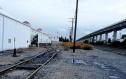 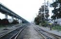 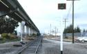 Date: 10/08/15 11:36 Re: Mystery Photo Author: EtoinShrdlu >I had been under the impression that the track all the way to the right was WP's, but the one to the left that you're almost standing on was an SP drill track that paralleled the WP all the way down from Melrose. Was that not the case?
Between Magnolia Interlocking and San Leandro, the WP's line ran approximately parallel to and between one to three blocks on the land side of SP's line between W Oak and Niles. Both RRs had swicthing districts on the land side of their main tracks between "WP Crossing" on the SP ("SP Crossing" on the WP), the location where the SP's red electrics crossed the WP main line, and just short of 105th Ave. There was some sort of traffic and trackage rights agreement in which both RRs switched each other's districts. SP crews referred to the track next to the WP main line as the "Drill Track"; WP crews referred to the switching job which worked these districts as the "Long Street Job". The WP didn't have access to the SP's switching district on the water side of the Niles line. SP entered the drill track at it's north end with a lead which ran parallel to the electric lines but veered off and crossed the WP to the (RR) east of the diamonds leading to Melrose. The WP had a separate connecting track from its main line to the SP lead about 500 feet to the (RR) east of this. WP's right's didn't extend all the way to Elmhurst because the lead which the WP had access to ended before crossing 66th Ave. SP's 105th Ave lead took off from the WB track of the Niles line just W of the spring switch, curved off, went right up the center of 105th, crossed the WP, crossed E 14th, and went around behind the Chevrolet plant. There had been a connection at the plant to the outer end of the 7th St red electric line, but I'm unfamiliar with the trackage layout. Sometime after about 1990, the leads were re-arranged, extending the Drill Track to tie into 105th Ave lead a city block or two further east of where it used to end adjacent to the Fleishman's Yeast plant. When the Chevrolet plant closed (it had been a parts-only warehouse since the plant at Warm Springs was built, if not earlier), the 105th Ave lead became superfluous. Date: 10/08/15 13:09 Re: Mystery Photo Author: Westbound Here's my old post with track diagrams of this area.
http://www.trainorders.com/discussion/read.php?11,779666,779959#msg-779959 Date: 10/09/15 07:12 Re: Mystery Photo Author: spladiv What happened to the "spur" running off the branch that went from from Stonehurst to Durant and what about the rest of the branch from Stonehurst to Dowling?
Date: 10/09/15 15:11 Re: Mystery Photo Author: TonyJ spladiv Wrote:
------------------------------------------------------- > What happened to the "spur" running off the branch > that went from from Stonehurst to Durant and what > about the rest of the branch from Stonehurst to > Dowling? Good question. I'd like to know myself. Date: 10/11/15 13:19 Re: Mystery Photo Author: EtoinShrdlu >What happened to the "spur" running off the branch that went from from Stonehurst to Durant
Stonehurst branch isn't even listed in 1912 ETT. The 1929 ETT lists it but gives no "Durant". >and what about the rest of the branch from Stonehurst to Dowling? By the 1930s, "Dowling" had become "103rd Ave Jct". Keep in mind that the VOG re stations on any given line are what's listed in its schedule column in the ETT, not the included maps which frequently don't accurately reflect the true state of affairs listed in the ETT. Dowling/103rd Ave Jct went away as the result of discontining the red electrics. There were a few industries on this section of the 7st St line, for which the Stonehurst branch was the freight service access, but I have no idea how long they lasted after the electrics went away. Bob Ford's book doesn't give a dteailed map of the Dutton Ave area of the line. When I worked jobs which went up to the Chevrolet plant (latter 1970s), you could see where the line had gone on to 103rd Ave Jct, but that section had been torn out. Date: 10/12/15 07:30 Re: Mystery Photo Author: spladiv I'll dig through my ETT's later, right now the best I can do is reference the Western Division map dated September, 1923. It shows a line leaving Stonehurst and going easterly (on a slight curve) to Durant.
Edited 1 time(s). Last edit at 10/12/15 08:27 by spladiv. |