| Home | Open Account | Help | 294 users online |
|
Member Login
Discussion
Media SharingHostingLibrarySite Info |
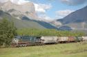
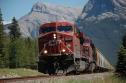
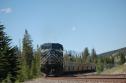
Canadian Railroads > Laggan Sub - June 26Date: 06/26/15 07:43 Laggan Sub - June 26 Author: KickingHorse Eastbound grain empties ... mile 65 at 08:30
   Date: 06/26/15 08:03 Re: Laggan Sub - June 26 Author: rbutterfield All hits and runs, no errors!!
Date: 06/26/15 09:38 Re: Laggan Sub - June 26 Author: Torisgod What is the line that goes steeply and steadily up the mountainside in the background? It looks too steep to be a railroad: is it a highway?
Tor in Eugene Date: 06/26/15 11:10 Re: Laggan Sub - June 26 Author: KickingHorse Torisgod Wrote:
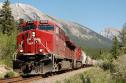
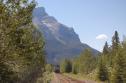
------------------------------------------------------- > What is the line that goes steeply and steadily up > the mountainside in the background? It looks too > steep to be a railroad: is it a highway? > > Tor in Eugene Definitely too steep to be a railroad. Spray Lakes Road - from just past the Canmore Nordic Centre (site of the Nordic events 1988 Olympics) it becomes a gravel road. The part you can see in the pic has a lot of washboard due to the steepness so 20 mph is about all you can do going up or down. The Nordic Centre is just off-pic to the right. It was originally built by Calgary Power (now called Trans-Alta) as part of their Spray Lakes Hydro development.That vertical line you can see at the top of the road is a surge tower for the pipline that drops down to a power plant below. The road continues through the gap in the mountains and goes to the Spray Lakes reservoir. From part way along the reservoir the road becomes the Smith-Dorrien road and goes SE to Kananaskis Lakes where it joins Hwy 40. Taking Hwy 40 north to its junction with the Trans-Canada Hwy 1 near Ozada West and then Hwy 1 or Hwy 1X/1A back to Canmore is a real nice circle tour. We do a lot of work for Trans-Alta and I had to go up to Spray Lakes on Wednesday. On my way back, I stopped near the top and took some pics. There was no train coming soon (MOW work block) but here's a pic that shows the rail line from about mile 65.2 to mile 65.7. The rest of the track through Canmore is obscured by forest or buildings. This pic is at full zoom - 300mm. You can't see my office but it's across the street from the green-roofed building. 2. Through the downtown area. The rail line goes straight across the middle of the pic right-to-left. You can see about 2 car lengths of the track on the right side. 3. The Rundle canal - takes water from the Spray plant to another pipeline that runs down to the Rundle plant on the Bow River. Edited 1 time(s). Last edit at 06/26/15 11:18 by KickingHorse. 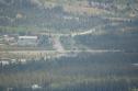 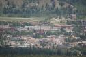 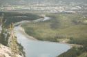 Date: 06/26/15 15:19 Re: Laggan Sub - June 26 Author: Train611 Good for you KH!
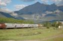
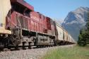
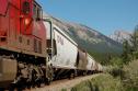
A very spectacular location! OH yea...the photos are good too!! 611 Date: 06/26/15 15:44 Re: Laggan Sub - June 26 Author: KickingHorse 603 potash .... Gap West ... 15:20
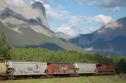
   Date: 06/26/15 15:51 Re: Laggan Sub - June 26 Author: KickingHorse 303 Grain .... mile 70.x ... 16:15
   Date: 06/26/15 15:53 Re: Laggan Sub - June 26 Author: rschonfelder Boy Canmore has grown. I worked on the Smith Dorrien Road project in my final summer of University (1981). Interesting to be working up in the mountains but meeting some of the transient characters who worked on that project sure made me want to finish University I can say.
Rick Date: 06/26/15 18:52 Re: Laggan Sub - June 26 Author: 3rdswitch They don't require rear end markers in Canada? No headlight, device or flag on the CEFX DP?
JB Date: 06/26/15 20:26 Re: Laggan Sub - June 26 Author: dizzy85 They used to hang reflective red markers from the walkway chains on CEFX units.
|