| Home | Open Account | Help | 235 users online |
|
Member Login
Discussion
Media SharingHostingLibrarySite Info |
Railroaders' Nostalgia > AFT Maps Kansas City to Jefferson CityDate: 04/09/14 17:47 AFT Maps Kansas City to Jefferson City Author: BoilingMan This one was on the MoPac, and rather straight forward. UP did the switching in KC, then MP to Jefferson City. I'm not 100% sure, but I think the two MP Bicentennial GP's were used. A little over 160 miles, so there was probably a water stop but I don't know where. If I find out I'll up date this post. The display site track is still there.
Edited 2 time(s). Last edit at 10/09/14 21:24 by BoilingMan. 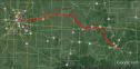 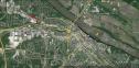 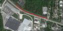 Date: 04/10/14 00:39 Re: AFT Maps Kansas City to Jefferson City Author: Red Ah--a very beautiful little town that I was lucky enough to hoghead out of for a very few short years. I wish I'd stayed there, but--well--wouldn've had to have moved to KC had I stayed. A very clean and gorgeous little town. Nice shot of the State Capitol Building there. With the Governor's Mansion not too far away although I can't locate it in those shots.
We had an MP/UP hoghead who was also the Local Chairman who'd served a term as the Mayor of Jeffereson City for one term!!! Edited 1 time(s). Last edit at 04/10/14 00:41 by Red. Date: 10/05/14 15:37 Re: AFT Maps Kansas City to Jefferson City Author: steveb Just found this thread. Very interesting and brings back many good memories!
After arriving in JEF the AFT was backed out on the east leg of the Wye onto the Bagnell Branch. (This is the old MO PAC branch to Bagnell, MO) The train was backed about 3/4 to 1 mile out the branch and displayed along industrial drive, north of Von Hoffmann Press. Von Hoffmann and the city built a gravel parking lot on the property for folks to use while visiting the train. I worked at Von Hoffmann at the time and have a bunch of pictures if I can find them. Steve Date: 10/05/14 16:39 Re: AFT Maps Kansas City to Jefferson City Author: BoilingMan Do I have the train drawn in the right spot?
I was going with Google Earth and my photos that show the Capitol dome in the background. If I need to edit the map please let me know. Thanks! SR Posted from iPhone Date: 10/05/14 18:06 Re: AFT Maps Kansas City to Jefferson City Author: steveb If I recall correctly, the train pulled up to the east of the capital to the MO PAC depot and maybe took water. Then backed up to east leg of the WYE and on out the branch. I remember it was a really big deal seeing that train and Daylight Locomotive going out on the branch! I have photos of the move but who knows where. Your pictures could have been taken while the train was stopped, before the reverse move.
Some of the building in the current photo were not built yet. The parking lot I talked about was where the long building is now. I tried to draw the path on Google Earth. Please excuse my fumbling! Steve 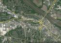 Date: 10/05/14 19:01 Re: AFT Maps Kansas City to Jefferson City Author: BoilingMan Very nice! Thank you!
My picture was taken while the train was on site (note the flags- we didn't move with the flags up). From the shadows I'd say it's in the morning. I had assumed the dome was to the west, but you've shown me it was to the south. This is really helpful, and I thank you. This was nearly 40yrs ago and I was with the train for 90 odd cities, so it's sometimes difficult to remember where we were for 4days in a strange city all those years ago! I'll update my map in a couple of days. SR Posted from iPhone Date: 10/06/14 05:37 Re: AFT Maps Kansas City to Jefferson City Author: BoilingMan I had a chance to look at this closer last night. I used the street view and I couldn't see the Capitol dome from the location you marked. I had to go much closer to town before it came into view. Are you sure we were that far up the branch?
SR Date: 10/06/14 10:52 Re: AFT Maps Kansas City to Jefferson City Author: steveb I remember the display cars being parked across from the present day long building with the present day siding. Just to be sure, I'll ask some of the guys who also worked with me at Von Hoffmann. I'll also check with the local newspaper archives.
Steve Date: 10/06/14 13:02 Re: AFT Maps Kansas City to Jefferson City Author: BoilingMan I'll be back home on Wed and I look and see if there are clues in any other photos I took.
But the photo with my story was definitely taken while the train was on site, and you can easily see the dome (although I was using a longish lens at the time). I don't think anyone else has tried to tell the AFT story quite as extensively as I am now, and so this might end up being the go-to source if info someday. With that in mind I'm trying to get it right, and don't mind fussing over details like this. The pay off is a more accurate record. SR Posted from iPhone Date: 10/07/14 17:50 Re: AFT Maps Kansas City to Jefferson City Author: steveb I've been checking with former employees and another foamer. They all say the train was parked where I have marked on Google Earth. One of the guys was a Scout and helped directing people from the parking lot to the train, etc.
I have also included a view I took today from the road next to the tracks. I imagine 4449 would have been about where the crossing sign is or maybe a little east. The trees in the pic would have been much smaller 40 years ago, if they were there at all. Hope this helps! Steve 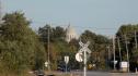 Date: 10/07/14 18:02 Re: AFT Maps Kansas City to Jefferson City Author: BoilingMan Oh! That's very convincing!
Nice. I'll change the map tomorrow when I get home. Thank you! SR Posted from iPhone |