| Home | Open Account | Help | 158 users online |
|
Member Login
Discussion
Media SharingHostingLibrarySite Info |
Eastern Railroad Discussion > East coast whereisit!Date: 02/24/06 15:52 East coast whereisit! Author: Pj Alright...finally got out and about today that has been bugging me everytime that I have passed this place, even before I moved anywhere near here.
This location looks much better and more intriguing from an elevated location, but I couldn't get there. The tracks in the background are still in use, but the 2nd track is part of a siding (which is CWR, but the main is jointed..you figure that out!) This may be difficult unless you live in the area, not a lot to go on in the first two picutures. I'll post a third if people get stumped (which may give it away). The signals you see are just west/north of the bridge. 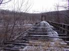 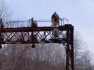 Date: 02/24/06 16:22 Re: East coast whereisit! Author: mjbobb I'm going to guess the abandoned bridge was the old Erie at one time and the tracks in service are the ex. DL&W main now part of Steamtown and the DLRR. This is the spot plainly seen from the I.380 just to the south of Scranton.
Date: 02/24/06 16:47 Re: East coast whereisit! Author: BaltoJoey Here is an overhead shot. http://terraserver.microsoft.com/image.aspx?T=1&S=10&Z=18&X=2248&Y=22921&W=3&qs=%7cscranton%7c%7c
Date: 02/24/06 17:49 Re: East coast whereisit! Author: mjbobb This was the old EL that came in from Hawley/Lackawaxen,PA., right? I guess it was torn out well over 30 yrs ago.
Date: 02/24/06 20:08 Re: East coast whereisit! Author: Pj BaltoJoey Wrote:
------------------------------------------------------- > Here is an overhead shot. > http://terraserver.microsoft.com/image.aspx?T=1&S= > 10&Z=18&X=2248&Y=22921&W=3&qs=%7cscranton%7c%7c Close, but wrong bridge...this one is the next one down just off your link. I was suprised it went that quick. My maps show that there may be been 3 lines running thru here. What/whose were they? One of them did branch off and run to Lake Ariel, PA but not to Laxawaxan as far as I know. That came off the Erie from the Southern Tier line and ended in Honesdale. I am not aware of any connected between this one and the other, although it may have been possible. Most the the ROW from the above area is visable for some distance as it paraells Rt590? for some distance. I could not find any evidence in the Lake Arial area as the maps show. As in this area of the bridge, there are a couple of abandonded brick buildings. One dating from 1909. Anyone know what was here? Down the hill across from the signal bridge is also a building down next to the river. When was the signalling taken out of service, and did CR ever run anything thru here? Lots of neat roadside artifacts all thru the area. Date: 02/24/06 20:31 Re: East coast whereisit! Author: mjbobb I was told by someone a few years back that this was a branchline of the Erie's and came off that line that went from Lackawaxen to Honesdale at Hawley. Would have to get some old topo maps out. The DL&W and that Erie line parelled each other along rt.590 the old Erie line took off to the left before you would reach Elmhurst. Dont remember if this was by an overhead bridge or underpass. I would also like to know when the signals were deactivated. If CR did this or the EL. I also believe CR ran a couple trains on this line in CR's early days as i remember seeing a slide or a pic. from someone of a CR autorack train crossing Tunkhannock{Nicholson} viaduct.
Date: 02/24/06 21:47 Re: East coast whereisit! Author: Pj As far as I can tell, all the signals are still in place from Scranton to Slateford Junction (or thereabouts). Most of the wayside poles are still up, however the wayside boxes (most still of wood construction) are stripped. Transformers on poles and underground lines are in place along the way. It really is a throw back in time.
Date: 02/24/06 21:58 Re: East coast whereisit! Author: BaltoJoey Mea culpa for the photo error. The bridge looked kind of right to me. LOL
I looked at the Terra Sever topo map and it shows the Erie going from Lackawaxen to Hawley and then ending in Honesdale. In fact in some places it credits it as the Lackawaxen & Stourbridge RR !! BaltoJoey Date: 02/25/06 07:54 Re: East coast whereisit! Author: TV-10 Date: 02/25/06 09:55 Re: East coast whereisit! Author: Pj That would be it. The access road to the left of I380 isn't as wide is it looks....as I found out. But, the suburban did fit most of the way. Would have been all of the way if there wasn't ice and I wanted to get out before spring. Other side was much easier once I saw how the layout was.
Date: 02/25/06 15:46 Re: East coast whereisit! Author: TV-10 Then mjbobb had it right, that is the Erie's Wyoming Branch crossing over the DL&W. The Wyoming branch split off the Erie main at Lackawaxen. At Hawley, the lines to Scranton and to Honesdale split. The segment between Gravity and Hawley was abandoned in the late 50's, early 60s. Lackawaxen to Hawley (and on to Honesdale) is still in place.
Date: 02/25/06 15:50 Re: East coast whereisit! Author: mjbobb I wonder what the main purpose was for the Erie in Scranton? Guess since the DL&W/Erie merger, they didn't need the line anymore due to them already having access to Scranton by the mainline.
Date: 02/25/06 16:02 Re: East coast whereisit! Author: TV-10 Early on, it was the Anthracite business just as it was for the DL&W. Also, the Erie's system car shops were in Dunmore.
The new (1958) car shops built in Meadville PA, a better location being near the mid-point on Erie's NY-Chicago run, eliminated the sole remaining "need" to retain the branch after the Anthracite era closed. |