| Home | Open Account | Help | 288 users online |
|
Member Login
Discussion
Media SharingHostingLibrarySite Info |
Eastern Railroad Discussion > Probably not so hard whereisitDate: 02/25/17 05:24 Probably not so hard whereisit Author: JPB Photo taken 3.5 years ago courtesy of Google Maps Street View cam car...
What RR built this track? And in what year was this track first used? Bonus points for mentioning other RRs relevant to this location... Edited 1 time(s). Last edit at 02/25/17 05:29 by JPB. Date: 02/25/17 05:50 Re: Probably not so hard whereisit Author: njmidland Lehigh Valley?
Date: 02/25/17 05:55 Re: Probably not so hard whereisit Author: P PRR Middle Division. West of Huntingdon?
Date: 02/25/17 06:27 Re: Probably not so hard whereisit Author: mjbobb Thats CP Corning Corning,NY
Date: 02/25/17 06:38 Re: Probably not so hard whereisit Author: JPB mjbobb Wrote:
------------------------------------------------------- > Thats CP Corning Corning,NY That is correct! How about what RR built this track, when was it first used, and what other RRs were in this neighborhood? Date: 02/25/17 06:38 Re: Probably not so hard whereisit Author: perklocal Corning,NY looking west off of Rte. 414. Train is Eastbound on the ex Erie. The DL&W main used to parallel the Erie off to the right. There is a wye right here that connects with the former NYC Corning Secondary.
Date: 02/25/17 06:45 Re: Probably not so hard whereisit Author: ironmtn Junction of I-90 and US 14 and 61 near Dresbach, Minnesota on the Mississippi River, opposite La Crosse, Wisconsin. The river can be seen just above the overpass under which the train is passing. The railroad was the Milwaukee Road, built by original predecessor Chicago, Milwaukee & St. Paul around 1872, and is CP trackage today.
The current Google Earth view is very different due to reconstruction of the interchange, which is depicted in the street-level view. The Upper Mississippi Valley is beautiful country, especially in autumn. Good railroading, too! MC Muskegon, Michigan Date: 02/25/17 06:53 Re: Probably not so hard whereisit Author: ironmtn ironmtn Wrote:
------------------------------------------------------- > Junction of I-90 and US 14 and 61 near Dresbach, > Minnesota on the Mississippi River, opposite La > Crosse, Wisconsin. The river can be seen just > above the overpass under which the train is > passing. The railroad was the Milwaukee Road, > built by original predecessor Chicago, Milwaukee & > St. Paul around 1872, and is CP trackage today. > > The current Google Earth view is very different > due to reconstruction of the interchange, which is > depicted in the street-level view. The Upper > Mississippi Valley is beautiful country, > especially in autumn. Good railroading, too! > > MC > Muskegon, Michigan I responded before I saw the other responses, which came in while I was typing. You coulda (and did) fool me. Amazing how similar two locations hundreds of miles apart can be. I shoulda known from the blurred-out New York license plate (as if vehicles from New York never travel to Wisconsin or Minnesota). Clever to include the "14" from the Google view. I thought that helped to nail it as US 14, which is part of the junction at Dresbach. Good gotchas. Full marks. MC Muskegon, Michigan Edited 1 time(s). Last edit at 02/25/17 06:57 by ironmtn. Date: 02/25/17 11:54 Re: Probably not so hard whereisit Author: mjbobb The NYC trackage used to go under the Erie and DL&W here and cross the river into the city of Corning
Date: 02/25/17 15:21 Re: Probably not so hard whereisit Author: NYSWSD70M mjbobb Wrote:
------------------------------------------------------- > The NYC trackage used to go under the Erie and > DL&W here and cross the river into the city of > Corning You can even see the Erie over NYC bridge under the train. For some reason, when they built the new Route 17 in the mid 1990's (now I86/RT17), they left the bridge. Date: 02/26/17 02:31 Re: Probably not so hard whereisit Author: JPB Here are a couple of TO posts from a few years ago that describe how the Erie RR got to be in the location that the Google Street View cam passed. The 1st URL has a terrific picture of DL&W's wb Phoebe Snow coming through the area shown in the GM Street View photo as the Erie RR was building its by-pass of downtown Corning that was first used in November 1952. The original Erie RoW went through downtown Corning south of the Chemung River and the 8 mile long bypass was built parallel to the DL&W mainline on the northside of the river, eliminating 25 grade crossings. I've read that from 1952 to around or just before the EL merger in 1960, there were two double track mainlines featuring something like 60 freights and 16 passenger train each day. Today perhaps 10 - 12 NS trains run through Corning per day.
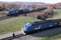
http://www.trainorders.com/discussion/read.php?11,2017683 http://www.trainorders.com/discussion/read.php?2,3128522 Date: 02/26/17 12:50 Re: Probably not so hard whereisit Author: PCCRNSEngr This is what it looked like before the highway construction. Taken October 24, 1978 with the 4022 waiting for the eastbound to passs before heading east. It was now a deadhead move after being used for Gov Carey Campaign Special. The third car of the freight is on the bridge that went over the NYC.
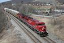
 Date: 02/26/17 12:57 Re: Probably not so hard whereisit Author: PCCRNSEngr Now here is a shot taken from the westside of the eastbound lane Route 17-I86 of NS 38T CP 8811 April 10, 2008
 Date: 02/28/17 12:28 Re: Probably not so hard whereisit Author: JPB Your October '78 picture is very interesting - Two ex-Erie Lackawanna E8s waiting on a freight to pass on the EL main! The Nathan air chime is a little out of place, though...
Edited 1 time(s). Last edit at 02/28/17 12:29 by JPB. |