| Home | Open Account | Help | 309 users online |
|
Member Login
Discussion
Media SharingHostingLibrarySite Info |
Passenger Trains > Need some location info please...Date: 04/18/15 11:48 Need some location info please... Author: Amtrak288 Thanks to everyone who has commented in my past posts needing location information for pictures for this travelogue. The 2 I have for this post are both from the Los Angeles area so here goes:
1. This first photo was taken just after crossing the Los Angeles River, what mainline is this that we're riding over? 2. What CP is this that we're going past? It's just before Mission Tower and LAUPT. Also, The place where Santa Fe 4-8-4 #3751 is parked, is that still called the Redondo Roundhouse, or do I have it mislabeled? Also, we seem to go over a flyover after going over the Los Angeles River before going past the roundhouse and the 8th Street Yard and shops. Is there a name for this flyover? The photos by the way were taken while riding #3 last November. Edited 1 time(s). Last edit at 04/18/15 11:49 by Amtrak288. 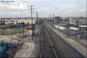 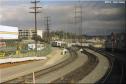 Date: 04/18/15 14:52 Re: Need some location info please... Author: Mudrock First picture the mainline is the Union Pacific leads to the Alameda Corridor
2nd Picture is approckimg Mission Tower. Chris Date: 04/18/15 18:54 Re: Need some location info please... Author: SDA_Brakeman The First Photo is on the Metrolink Flyover near CP Soto. The Second is looking toward mission tower. It may not have a CP name other than its milepost. Also, the Amtrak crews now call the tracks at the Redondo turn table the "Whisker Tracks."
Edited 2 time(s). Last edit at 04/18/15 18:57 by SDA_Brakeman. Date: 04/18/15 19:28 Re: Need some location info please... Author: SCAX3401 As stated earlier, the first photo is taken from the Flyover at Redondo Junction. Officially the flyover is part of Metrolink's River Subdivision, West Bank Line. Also as stated earlier, the mainline underneath is Union Pacific tracks to the Alameda Corridor. Officially, the control point right under the flyover is CP EAST REDONDO. Behind the photographer it would be Union Pacific's Los Angeles Subdivision and the going away from the photographer is the Alameda Corridor Subdivision. In the distance is CP WEST REDONDO with the BNSF San Bernardino Sub joining in from the left side.
The second photo is taken about 5 miles further north near the entrance to LA Union Station. The Control Point here is CP SAN DIEGO JCT. on the Metrolink River Subdivision, West Bank Line. Prior to the flyover construction, the Metrolink tracks crosses the tracks seen below in Photo 1 just in front of the tower as a odd angle (thus the tower not being square with the remaining trackage. Edited 2 time(s). Last edit at 04/18/15 19:32 by BNSF6400. |