| Home | Open Account | Help | 254 users online |
|
Member Login
Discussion
Media SharingHostingLibrarySite Info |
Passenger Trains > Merck & Company (Backlit Sprinter and NJT at Linden, NJ)Date: 02/09/16 10:58 Merck & Company (Backlit Sprinter and NJT at Linden, NJ) Author: Mgoldman January 27th, 2016 - Amtrak Cities Sprinter #605 roars through Linden, NJ passing an NJT
train in push mode. Merck & Company's large pharmaceutical factory serves as the back- ground for the shot taken at 3:51 PM. /Mitch 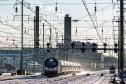 Date: 02/09/16 14:34 Re: Merck & Company (Backlit Sprinter and NJT at Linden, NJ) Author: Lackawanna484 Thanks for the picture. I believe you were near the one time North Rahway station. It was a mostly walk up, and closed years ago.
Posted from Android Date: 02/09/16 16:59 Re: Merck & Company (Backlit Sprinter and NJT at Linden, NJ) Author: Mgoldman Lackawanna484 Wrote:
------------------------------------------------------- > Thanks for the picture. I believe you were near > the one time North Rahway station. It was a mostly > walk up, and closed years ago. I should've mentioned - the shot was taken from the end of the platform at the Linden, NJ station. Was not aware of a North Rahway station. Is there any reminents of the place? I understand there was a station near Iselin, NJ that was replaced with Metropark at a new location. Wondered if that was still standing? Getting a little off track - but I've wondered why so few stations exist between Princeton Junction and - what's the next, Jersey Ave. Seems a large gap. What ever became of Momouth Junction? /Mitch PS - Interesting find regarding Merck & Company, Wiki states: The company was established in 1891 as the United States subsidiary of the German company Merck, which was founded in 1668 by the Merck family. Merck & Co. was nationalized by the US government during World War I and subsequently established as an independent American company in 1917. It is the world's seventh largest pharmaceutical company by market capitalization and revenue. Date: 02/09/16 17:16 Re: Merck & Company (Backlit Sprinter and NJT at Linden, NJ) Author: Lackawanna484 North Rahway was also known as Scott Avenue.
Deans and Adams were both passenger stations on the NEC. You can see the one time access from the over head bridges. Way back in 1910, stations south from New Brunswick included Franklin Park at 35.5, Deans at 38.5, Monmouth Jct at 41, and Plainsboro at 45.5. Lawrence was at 51.2 Posted from Android Date: 02/10/16 10:24 Re: N Rahway Author: timz North Rahway closed around 1991-- one or
two NJT trains a day had stopped there. Inbound platform was on the north side of Scott, outbound on the south. Date: 02/10/16 12:02 Re: N Rahway Author: knotch8 Iselin station and Metropark (originally spelled Metro Park) coexisted for a little while after Metropark opened in the late 60's. Iselin station was east of what's now Iselin Interlocking, on the south side of the main line, alongside Middlesex-Essex Turnpike, just below Berkley Blvd. On this map https://www.google.com/maps/place/Iselin,+Woodbridge+Township,+NJ/@40.5726668,-74.3214144,19z/data=!3m1!1e3!4m2!3m1!1s0x89c3b683d3f8e567:0xedc14288e37cf1d7 it was located just east of Metro Park Motors but there's no remaining trace.
As mentioned above, North Rahway was designed to serve the Merck plant and was located on the west side of Scott Ave, an undergrade bridge as seen here: https://www.google.com/maps/place/Rahway,+NJ/@40.6131026,-74.2691574,20z/data=!3m1!1e3!4m2!3m1!1s0x89c3b38e65d6d627:0x46350483d9a047d9 The eastbound platform was between Tracks A and 1 (the 2 southermost tracks) and the westbound platform was only accessible from Track B (the northernmost track). From Scott Ave, beneath the railroad, here's where the stairway went up to the eastbound platform https://www.google.com/maps/place/Rahway,+NJ/@40.6132981,-74.2690939,3a,66.8y,-121.18h,88.04t/data=!3m4!1e1!3m2!1sdm1AahMPhi90AyDz8-Neqg!2e0!4m2!3m1!1s0x89c3b38e65d6d627:0x46350483d9a047d9 and where it went up to the westbound platform https://www.google.com/maps/place/Rahway,+NJ/@40.6134395,-74.2693082,3a,66.8y,-149.14h,84.94t/data=!3m4!1e1!3m2!1slg2rwHNkSJ2SzGsYzJOrZw!2e0!4m2!3m1!1s0x89c3b38e65d6d627:0x46350483d9a047d9 It looks like you might have to rotate the images to see the closed-off staircases. You can see the staircases connecting the Adams Lane overpass with the long-gone platforms in this aerial view: https://www.google.com/maps/place/Deans,+NJ+08852/@40.4476113,-74.4911977,20z/data=!3m1!1e3!4m2!3m1!1s0x89c3c345e7f336e5:0x155a04f7f1389145 Edited 2 time(s). Last edit at 02/10/16 12:12 by knotch8. |