| Home | Open Account | Help | 371 users online |
|
Member Login
Discussion
Media SharingHostingLibrarySite Info |
Railfan Technology > Oops! Hey Google, I ain't going across that bridge.Date: 11/25/15 15:24 Oops! Hey Google, I ain't going across that bridge. Author: wa4umr Sometimes Google Earth really gets it wrong. I was looking at the bridge at High Bridge, Ky. where the NS crosses the Kentucky River between Lexington and Danville. Looks a bit strange. The tracks on the bridge are 30' to 50' above the tracks on the ground. The tracks on the ground go under the bridge, down a steep hill (a steep grade I guess) and crosses the river. I would imagine that would be a rather rough crossing.
The last time I crossed that bridge was behind NKP 765. We were hitting a milepost every 45 seconds. Glad the tracks didn't look like that back then. I know, if you've ever done much looking at Google Earth you've seen several cases where rails and highways make some strange twist and turns when there is something above or below grade. It's still a good tool if you are looking for a place to chase trains. John 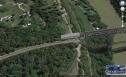 Date: 11/25/15 16:41 Re: Oops! Hey Google, I ain't going across that bridge. Author: ble692 Check out this Bing maps streetview on the CORP tracks near Creswell, OR. Not a mapping error, but human error for sure. I'll I can say is wow. How did they actually put this up?
http://binged.it/1IhTaKe Date: 11/26/15 10:36 Re: Oops! Hey Google, I ain't going across that bridge. Author: RFandPFan Now that's an interesting "lift span"!!!
Date: 11/27/15 16:27 Re: Oops! Hey Google, I ain't going across that bridge. Author: Chooch Maybe the bottom portion is meant to be an amusement ride.
Jim Hatboro, PA Date: 11/27/15 19:30 Re: Oops! Hey Google, I ain't going across that bridge. Author: Railbaron ble692 Wrote:
------------------------------------------------------- > Check out this Bing maps streetview on the CORP > tracks near Creswell, OR. Not a mapping error, > but human error for sure. I'll I can say is wow. > How did they actually put this up? > > http://binged.it/1IhTaKe They caught themselves going around gates that were down, although scanning in both directions shows no train was coming. Date: 11/27/15 21:12 Re: Oops! Hey Google, I ain't going across that bridge. Author: ble692 Railbaron Wrote:
------------------------------------------------------- > They caught themselves going around gates that were down, although scanning in both directions shows no train was coming. Probably the gates were in fact screwed up (broken rail, occupancy of some sort), but I sure am not going to try using that argument in court to challenge a ticket for going around the gates! Date: 11/28/15 00:10 Re: Oops! Hey Google, I ain't going across that bridge. Author: stormhighway The "higher" bridge is a 3D model, the lower 'bridge' is part of the aerial image that is deformed to fit the contour of the terrain. The 3D models of buildings, bridges and other landmarks in Google Earth are custom-built by various people. In this case, the bridge is probably the work of a railfan who has some interest in that bridge. Whether or not an object in Google Earth has a 3D model representing it depends on someone with the software and know-how having an interest in making it.
|