| Home | Open Account | Help | 289 users online |
|
Member Login
Discussion
Media SharingHostingLibrarySite Info |
Western Railroad Discussion > More Tehachapi tunnel stuffDate: 12/02/05 09:22 More Tehachapi tunnel stuff Author: pecosvalleychief I'm starting a new thread about this because someone on the last thread said they wouldn't be able to view the second page.
I've been poking around and googled up this photo I thought was interesting. It's from the website of the Southern California Earthquake Center and is credited to the Southern Pacific. Looks to me like the tunnel wall was lifted, the track moved, then the wall was set back down. Awesome display of seismic power. This is reportedly insdie #3. Allen in B-town 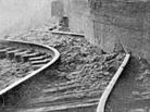 Date: 12/02/05 09:52 Re: More Tehachapi tunnel stuff Author: pecosvalleychief This was 1952 on the White Wolf fault. for more in-depth discussion, see:
http://www.trainorders.com/discussion/read.php?1,1047962 Date: 12/02/05 10:04 Re: Fort Tejon info for Tom Author: CPRR The 1857 Ft. Tejon Earthquake: In Brief
Many people think that the 1906 San Francisco earthquake was the largest earthquake to strike California in historical times, but that distinction actually belongs to the shaker that rocked southern and central California on January 9, 1857, uprooting trees in the San Bernardino Mountains and causing the Kern River to flow backwards for a time. Because of the small population in the state in 1857 (perhaps 350,000 people), there were only two fatalities, one near Fort Tejon, where many buildings were destroyed. The earthquake was strongly felt from Los Angeles to San Francisco. The rupture on the surface of the earth can still be traced to this day, extending from near Parkfield, California, to near San Bernardino, California, over a distance of roughly 225 miles. Strong shaking from the earthquake was said to last from 1 to 3 minutes. The earthquake occurred along the San Andreas fault, the major fault in California. The latest estimate of the size of this earthquake is magnitude 7.9. An earthquake of this size will certainly recur along the San Andreas fault, with devastating results given California's population today. The average recurrence interval for this earthquake has been estimated at 140 years ± 40 years. Since it is already 144 years since the last earthquake, the next one may not be too far in the future. Despite the size of the earthquake, it occurred far enough away that only minor damage occurred in Santa Barbara, although the earthquake was strongly felt in that city. Ft Tejon is about 10-20 miles west of the T Loop Date: 12/02/05 10:35 Re: Fort Tejon info for Tom Author: JohnSweetser CPRR wrote:
>Ft Tejon is about 10-20 miles west of the T Loop. Actually, Fort Tejon is 30 miles southwest of the Tehachapi Loop. Date: 12/02/05 11:00 Re: More Tehachapi tunnel stuff Author: JohnSweetser For another Tehachapi tunnel photo taken after the 1952 earthquake that's in the collection of the Earthquake Engineering Research Center at University of California Berkeley, go to:
http://nisee.berkeley.edu/jpg/2350_1031_0606/IMG0078.jpg The photo is of the west end of Tunnel 4 taken on August 26, 1952, which was eleven days after the rail line was reopened. Later, the end of the tunnel seen here was sealed with a smooth concrete cap. As I stated in the previous thread, this part of Tunnel 4 had always been exposed to the air, apparently an extension from the original bore to provide slide protection. Date: 12/02/05 12:56 Re: More Tehachapi tunnel stuff Author: SW_Chief Alan and the other Alan (in Phoenix), you would probably enjoy this tape very much:
http://www.pentrex.com/vr014.html While it is mostly late 1980's / early 1990's footage of operations over Tehachapi (and excellently done) it also includes a few minutes of footage from the '52 quake and the rebuilding MK did of the line for the SP. I would love to have a copy of the MK documentary that they likely did (like they did for several other RR projects, including the NWP rebuild after the major/disastrous Christmas flooding in the early 60's - 1963? along the Eel river), but I am not aware of the Tehachapi film being as readily available as the other films MK shot. I've got 6 of them from Pentrex. The quake coverage in this Pentrex/VideoRails video (linked above)looks like it came from MK (and their documentary, if they did indeed do one on that project.) Check it out. I highly recommend it for any Tehachapi fan, regardless of the quake coverage. Greg Date: 12/02/05 13:00 Re: More Tehachapi tunnel stuff Author: pecosvalleychief Thanks for that heads-up Greg. By MK do you mean Morrison-Knudsen?
Allen Date: 12/02/05 13:28 Re: More Tehachapi tunnel stuff Author: BCHellman What's intriguing about the photo of exposed tunnel 4
http://nisee.berkeley.edu/jpg/2350_1031_0606/IMG0080.jpg are the buttresses that extend from the north side of the tunnel wall. I can understand the concrete lining -- its purpose and how it was done -- but how, and more importantly why, did they buttress the sides? Photos of tunnels in other areas that have been day-lighted show the lining, but not the buttress. I guess it had to with the stability and composition of the earth. Ironic because no amount of reinforcement saved this tunnel from the big one... Date: 12/02/05 14:25 Re: More Tehachapi tunnel stuff Author: ProAmtrak SW_Chief Wrote:
------------------------------------------------------- > Alan and the other Alan (in Phoenix), you would > probably enjoy this tape very much: > > http://www.pentrex.com/vr014.html > > While it is mostly late 1980's / early 1990's > footage of operations over Tehachapi (and > excellently done) it also includes a few minutes > of footage from the '52 quake and the rebuilding > MK did of the line for the SP. I would love to > have a copy of the MK documentary that they likely > did (like they did for several other RR projects, > including the NWP rebuild after the > major/disastrous Christmas flooding in the early > 60's - 1963? along the Eel river), but I am not > aware of the Tehachapi film being as readily > available as the other films MK shot. I've got 6 > of them from Pentrex. > > The quake coverage in this Pentrex/VideoRails > video (linked above)looks like it came from MK > (and their documentary, if they did indeed do one > on that project.) Check it out. I highly > recommend it for any Tehachapi fan, regardless of > the quake coverage. > > Greg I got that tape, and yeah great tape, especially when SP used to run them massive lumber drags over the loop, but with the earthquake Tunnel 5 if you guys forgot was so damaged that they left that tunnel alone until they got the line back up and running, and it took them another 3 months to get that back up and running (and it was a talk about daylighting it too, but after awhile they changed their minds! Date: 12/02/05 15:23 Re: More Tehachapi tunnel stuff Author: sdrake BCHellman Wrote:
------------------------------------------------------- > What's intriguing about the photo of exposed > tunnel 4 > > http://nisee.berkeley.edu/jpg/2350_1031_0606/IMG00 > 80.jpg > > are the buttresses that extend from the north side > of the tunnel wall. I can understand the concrete > lining -- its purpose and how it was done -- but > how, and more importantly why, did they buttress > the sides? Photos of tunnels in other areas that > have been day-lighted show the lining, but not the > buttress. I guess it had to with the stability and > composition of the earth. Ironic because no amount > of reinforcement saved this tunnel from the big > one... The buttressed part of the tunnel would have been exposed. They extended the tunnel out a ways from the actual hill and the extended part of the tunnel would provide protection for rock slides, etc. Date: 12/02/05 17:22 Re: More Tehachapi tunnel stuff Author: JohnSweetser Photos on page 70 and page 243 of the book "Earthquakes in Kern County, California During 1952" plus a photo on page 23 of Summer 2001 issue of SP Trainline (magazine of the SP historical society) indicate the part of Tunnel 4 with the buttresses (there are 5 of them) was never buried in the earth. In effect, this was a free-standing wall that needed to be strong to withstand slides, hence the reinforcing buttresses.
Date: 12/02/05 17:31 Re: More Tehachapi tunnel stuff Author: SW_Chief Hi Allen. I'm sorry about misspelling your name in my first post (and thanks for not ripping me for doing so.) Yes, that's Morrison-Knudsen whom I meant. Interestingly, one of their documentaries that I have is about MK doing UP's second line along the Sherman Hill route back in the early 50's (I think the new line is called the Harriman line, or maybe the original line is called that). One of the stations along the new line was/is EMKAY. I wonder if that is a play on words in deference to the contractor who built the line, MK?
Have a good weekend! Greg Date: 12/02/05 19:24 Re: More Tehachapi tunnel stuff Author: alan jacobson Greg,
I do have that Video Rails Tehachapi Loop tape that you mentioned and I hate to admit this but I, honestly, have no recollection of ever having looked at it. That will be rectified before a new day dawns. I suspect that it was given to me by a friend and then it got placed on the shelves and thereafter, dropped through the cracks. I had to look the collection over pretty intensely to find it. Maybe that's saying that I have just to darn many train tapes. :) Whatever the case, thanks for the heads-up. There has,certainly, been some neat stuff brought to light in these recent "Tehachapi tunnel" threads. John Sweetser, I was able to locate and purchase a copy of "Earthquakes In Kern County, California During 1952" and also the Summer 2001 issue of the "SP Trainline" (issue #68). I should have them shortly. Thanks for injecting those documents into the mix. Tehachapi! The experience never ends! It must be lived!! Alan Jacobson Phoenix, Arizona Date: 12/02/05 22:35 Re: MK and Sherman Hill Author: rob_l SW_Chief Wrote:
------------------------------------------------------- > Interestingly, one of the > documentaries that I have is about MK doing UP's > second line along the Sherman Hill route back in > the early 50's (I think the new line is called the > Harriman line, or maybe the original line is > called that). Harriman is a station on the new line. But I never heard the new line referred to as "the Harriman Line". I suppose that on occasion train and engine movements may have been advised that they would "run via Harriman". > One of the stations along the new > line was/is EMKAY. I wonder if that is a play on > words in deference to the contractor who built the > line, MK? It is indeed named in honor of Morrison Knudsen. UP always had a special relationship with MK, it being a resident of UP territory (Boise). MK did many projects for UP besides the 1953 Sherman Hill low-grade line. Best regards, Rob L. Date: 12/03/05 01:12 Re: More Tehachapi tunnel stuff Author: JohnSweetser Could someone provide a link to the first Tehachapi tunnel thread that was on the Western Board several days ago? (this thread is the third one of the series)
To answer tomk's question about how many tunnels were daylighted after the 1952 earthquake, the answer is two - Tunnels 4 and 6. Date: 12/03/05 04:39 Re: More Tehachapi tunnel stuff Author: AC4400CWGEVO I think is this one...
http://www.trainorders.com/discussion/read.php?1,1046566 Ac4400cwgevo JohnSweetser Wrote: ------------------------------------------------------- > Could someone provide a link to the first > Tehachapi tunnel thread that was on the Western > Board several days ago? (this thread is the third > one of the series) Date: 12/03/05 10:36 Re: More Tehachapi tunnel stuff Author: JohnSweetser To AC4400CWGEVO: Thanks for providing the link.
To Alan Jacobson: To answer your question in that first thread about what reference stated that Caliente and Jawbone canyons marked the southern limit of the the Sierra, I got that info from page 48 of "Flora of Kern County, California" by Ernest Twisselmann. Date: 12/03/05 10:38 Re: More Tehachapi tunnel stuff Author: JohnSweetser Actually, that should be "A Flora of Kern County, California."
Date: 12/03/05 19:23 Re: More Tehachapi tunnel stuff Author: JohnSweetser There are three scenes in sequence in Video Rails' "Tehachapi Loop" video that the narration identifies as the demolition of Tunnel 6 but I have serious doubts if this is true.
The first of the scenes I question shows earth movers traveling along a buttressed tunnel wall. Most likely, this was filmed at the north end (west end by railroad direction) of Tunnel 4, not Tunnel 6. The next scene is night footage of a wrecking ball working on a tunnel wall. It looks very similar to the night photo on page 28 of the Summer 2001 issue of SP Trainline, where the location is identified as Tunnel 4. Of course, it's always possible the SP Trainline caption was wrong instead. The third scene shows a wrecking ball on a crane knocking down a tunnel portal in daylight. The uphill side of the tunnel has to be to the left in the video since the crane had to work on the flat shelf carved out on the downhill side. So, this means the third scene was filmed either at the southeast end (east end by railroad direction) of Tunnel 4 or the north end (railroad east end) of Tunnel 6. The sunlight angle in the scene tends to rule out the north end of Tunnel 6, though. There is a lessor possibility the wrecking ball scenes were filmed at the south end of Tunnel 3. To determine for sure whether or not the southeast section of Tunnel 4 was removed entirely, as opposed to merely being bypassed, which is the usual assumption, would require dedicated railfans to make visual observations plus measurements at the site. This would also help establish the accuracy of the photo caption on pg. 28 of SP Trainline and tend to discredit the identification of Tunnel 6 in a portion of the video narration. |