| Home | Open Account | Help | 280 users online |
|
Member Login
Discussion
Media SharingHostingLibrarySite Info |
Western Railroad Discussion > Current fire mapDate: 10/24/07 10:10 Current fire map Author: smitty195 Good map that gives a quick snapshot of the chaos down there. Also updated to show the closure of the Surfline:
http://maps.google.com/maps/ms?msa=0&msid=114250687465160386813.00043d08ac31fe3357571&ie=UTF8&ll=33.074282,-117.285919&spn=1.08633,1.801758&z=9&om=0 Date: 10/24/07 10:26 Google Fire Map Collection Author: daniel3197 Here is the GOOGLE collection of many SoCal Google Fire Maps from the Google Blog.
This should give us a good idea about what areas are impacted: http://googleblog.blogspot.com/2007/10/southern-california-fire-maps.html ---Daniel Date: 10/24/07 10:27 Re: Current fire map Author: run8 It's interesting to see how extensive the fire area is, though the map only covers the fires in San Diego County, and is missing the new fires that have developed in Orange County.
Date: 10/24/07 11:43 Re: Current fire map Author: ddkid Look at
http://www.sdcountyemergency.com/ On the right side, in the "News Releases" block, there's a link to the latest version of the San Diego County fire map. It's extremely slow to load, so be patient. It's less cluttered with symbols than the Google map, so it's easier to see what's going on. There may be similar maps for the counties farther north, but I haven't explored them; my daughter and her husband live in San Diego (they're OK) so I've taken a personal interest there. Date: 10/24/07 13:47 Re: Current fire map Author: smitty195 The Santiago fire is now officially an arson fire. Sick ba****d.
Date: 10/24/07 13:56 Re: Current fire map Author: TopcoatSmith FBI went to a house in OC earlier, burn 'em at the stake ! (hey, they wanna play with fire, show 'em what it's like).
TCS - kudos the DH for following proper procedures, glad you're all ok. Date: 10/24/07 17:30 Re: Current fire map Author: CimaScrambler A very interesting infrared imagery map of the fires at
http://www.fireimaging.com/homepage.html You can select which fire to look at via links on the home page. Most recent fire map at http://www.sdcountyemergency.com/newsreleases/10242007_1600hrs_Evac_FirePerem.pdf I've turned the big map into a small jpg and attached here - hopefully not too many copyrights have been violated in the process. As you can see, the one affecting the surfline is still going strong, as is the one slowly eating its way east along State Highway 94 near Campo and the one running along the south face of Palomar Mountain. I suspect there won't be much astronomy done up that way this evening. - Kit  Date: 10/24/07 17:41 Re: Current fire map Author: CimaScrambler I'm posting the map again, only with a red X marking where the Campo railroad museum is located - since that isn't obvious from what was there.
- Kit 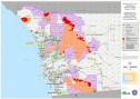 Date: 10/24/07 18:07 Re: Current fire map Author: ProAmtrak Man that's like 70-80% of that part of the state in flames!
Date: 10/24/07 19:49 Re: Current fire map Author: Charles That map is just San Diego County.
Date: 10/25/07 13:16 Re: Current fire map Author: TopcoatSmith That's gonna make avacados expensive, most of the Irvine Ranch groves (according to the maps) have gone up in flames too, haven't gotten down to verify how much yet.
TCS - project rattlesnake veteran |