| Home | Open Account | Help | 338 users online |
|
Member Login
Discussion
Media SharingHostingLibrarySite Info |
Western Railroad Discussion > Photo location at Chalender, AZ.Date: 05/27/20 21:21 Photo location at Chalender, AZ. Author: arizonaBNSF In the thread mococomike made yesterday (https://www.trainorders.com/discussion/read.php?1,5032195), the curve on the cover of "Canyonlands and Super Chiefs" by McMillian was brought up. Although the photos by mococomike were not taken at the same spot as the photo on the cover of the book, it is very close to the same area. The curve is at M.P. 369.7, about halfway between the current location of the Chalender crossovers and the former station of Davern (M.P. 371).
I've attached a few photos of the area and a shot that is taken at almost the same location as the one on the book cover. Actually, when I hiked to that spot and looked at the curve, I thought that it looked very similar to the book photo. 1) A WB stack train running left-hand at the curve. The photo on the McMillian book looks like it was taken a little further to my right in the photo as more of the mountains can be seen in his. The trees are probably a little bigger which makes a difference and he may have been on the opposite side of the bobbed wire fence. 2) Another shot at the same location about an hour before the first one. The later in the day it gets, the better sunlight will be at this spot. 3) Here's the same EB manifest from Mike's post. This is about where the double stacks curve out of view in the first two photos. Like Mike mentioned, this spot is rather accessible, it just requires a bit of hiking to get to it. 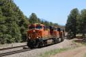 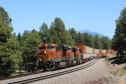 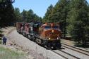 Date: 05/28/20 05:28 Re: Photo location at Chalender, AZ. Author: texchief1 Nice shots! How do you get there?
Thanks. Randy Lundgren Elgin, TX Date: 05/28/20 09:49 Re: Photo location at Chalender, AZ. Author: arizonaBNSF texchief1 Wrote:
------------------------------------------------------- > Nice shots! How do you get there? > > Thanks. > > Randy Lundgren > Elgin, TX Here's what I did: There is a forest service road that branches off of Sherwood Forest RD on the right as soon as the trees clear and the tracks come into view when driving toward the grade crossing. This road eventually parallels the tracks. You can drive down this until you find a loose spot in the bobbed wire fence and cross the tracks to the south side where that access road is. The spot where I was photographing is between M.P. 369 and 370. Alternatively, you can also drive on the south side access road from the grade crossing at M.P. 368, just keep in mind that this is on the RR side of the fence so park far back from the tracks. BNSF usually doesn't mind people on these roads. Like Mike said in this post, it is frequently used by ATV riders and hikers. Just be respectful and keep your distance and you should be fine. |