| Home | Open Account | Help | 320 users online |
|
Member Login
Discussion
Media SharingHostingLibrarySite Info |
Western Railroad Discussion > Drama in the Blues Part 2Date: 01/22/23 19:42 Drama in the Blues Part 2 Author: funnelfan Heading from Ontario toward Baker on I-84, I knew I was following a westbound ZG2BR which I overtook around Durkee. After some pics of it near Oxman I continued on ahead of it looking for other trains as a westbound in the morning hours doesn't offer much photo possibilities since the train is running away from the sun. I found a westbound stack train (IG4SE) holding for the Z train at Encina and a Soda Ash train at Quartz. At first I wasn't sure if the two units on the east end were the DPU's on a loaded westbound or the lead units on a empty (first pic). I also thought that maybe the train was a grain train because I associated the cars on the head end more with grain traffic than the soda ash traffic. It wasn't till later that I saw the cars that I associated more with soda ash traffic on the far end of the train.
I captured pics of the Z train and the stack train between Encina and Quartz. Then the soda ash train with just two units got a clear to leave Quartz. I noticed that the train negotiating the series of 6 degree curves in the second image was slipping badly and losing speed. I jumped ahead a short distance to the Ebell Creek Rd xing and by the time the train appeared it was down to a crawl and still slowing down. In fact it would be down to something less than walking speed shortly, but still inching forward. Looking close at my pics I could see that no sand was coming from the lead unit, only the trailing unit. In this 1.5% climb out of the Powder River Valley, the tracks bend through a series of 4 and 6 degree reverse curves between Quartz and Encina. I was thinking this train may stall out like the MNPPT was on the other side of the hill. Thankfully the helpers that were racing to save the stalled MNPPT were coming up not far behind. I heard the westbound stack train was being held down in the valley below somewhere to keep the helpers rolling. As the locomotives got onto the straight track before the 2 degree curve in the foreground it started to gain speed again and would eventually make it over the summit and onto the long downhill grade to the Snake River. Ted Curphey Ontario, OR 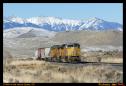 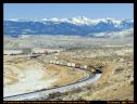 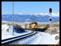 Date: 01/22/23 20:11 Re: Drama in the Blues Part 2 Author: funnelfan Satisfied that the train would not stall I went over the hill to a part of the line that I find rather interesting. From the Encina Summit down to Pleasant Valley the tracks descend on a 1.5% through some typical scenery. But it's past Pleasant Valley where the bottom drops out. Eastbound trains suddenly find themselves clinging to the hillside high above the valley floor on a steep 2.2% downhill grade twisting a turning through deep cuts and over tall fills. Access is not great, but there is one road crossing on the lower end of this section providing the view in the first image. Since most of the day the sun is on the uphill side of the tracks and the main road is on the downhill side with private land all around, it's going to take a drone or a lot of hiking to bring out the potential of this area.
The old highway shortcuts the railroad a great deal going down into Durkee on a direct route while the tracks turn into and back out of the Prichard Creek Valley. Once the tail end of the train clears the horseshoe curve at the back of the Prichard Creek Valley most trains are free to kick off the brakes and roll up to speed on the downhill over relatively straight track before having to throw the anchor out at Nelson to slow down for the twisted confines of the Burnt River Canyon below there. It's fun to see the trains that were carefully easing down the grade above at 20mph come blasting through the less than 1 degree curve at Durkee going 60mph like in the last image. In that image you can see the cars of the stalled MNPPT sitting high up on the hillside in the distance. Ted Curphey Ontario, OR 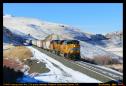 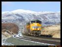 Date: 01/22/23 20:46 Re: Drama in the Blues Part 2 Author: oyw Nice work, really like that last one!
Date: 01/22/23 21:56 Re: Drama in the Blues Part 2 Author: Ritzville Very NICE series and narrative! Very enjoyable pictures with the trains and snowy mountains.
Larry Edited 1 time(s). Last edit at 01/24/23 08:58 by Ritzville. Date: 01/22/23 22:43 Re: Drama in the Blues Part 2 Author: mojaveflyer Great series with an excellent narrative! Thanks for sharing your adventure....
James Nelson Thornton, CO www.flickr.com/mojaveflyer Date: 01/23/23 00:55 Re: Drama in the Blues Part 2 Author: gobbl3gook Nice photos, again.
A few map links for folks wanting to follow this stretch of line digitally -- Durkee https://goo.gl/maps/2hUfbREto2ZXPyxy9 https://opentopomap.org/#map=15/44.59131/-117.46183 https://www.openrailwaymap.org/?style=standard&lat=44.58007522140787&lon=-117.45534896850585&zoom=12 https://www.topozone.com/map/?lat=44.58&lon=-117.4553 https://en.mapy.cz/zakladni?x=-117.4822003&y=44.5985819&z=12 To see full screen 1:24,000 scale USGS maps in their full glory, click on the little box in the upper left hand corner on topozone.com. Pleasant Valley, Oxman, etc. are to the west. Place names are best spotted on the USGS 1:100,000 scale maps. One question -- I've always considered the Blue Mountains to begin at La Grande on the Oregon Trail/UP/US 30/I-84 route. I seem to recall that in the Oregon Trail accounts, the emmigrants hadn't seen a green forest from St. Joseph MO to just after La Grande. "When they entered the Blue Mountains" After your post a couple weeks ago characterizing the Burnt River Canyon/Powder River sections of the UP line as the "Blue Mountains" I got curious. And couldn't find any other name for these mountains. And a physiographic map of Oregon shows the Blue Mountain province covering the drier mountains to the east of the main Blue Mountain range. Now I'm curious as to what other names there might be for this section of desert mountains between the Snake River and the Grande Ronde Valley and Baker Valley. South of the Wallowas, west of the Snake River Plain, and east of the "'high country' Blue Mountains." Just a curiousity. Best, Ted in OR Edited 3 time(s). Last edit at 01/23/23 09:50 by gobbl3gook. 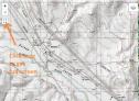 Date: 01/23/23 19:17 Re: Drama in the Blues Part 2 Author: funnelfan gobbl3gook Wrote:
> One question -- > I've always considered the Blue Mountains to begin > at La Grande on the Oregon Trail/UP/US 30/I-84 > route. I seem to recall that in the Oregon Trail > accounts, the emmigrants hadn't seen a green > forest from St. Joseph MO to just after La > Grande. "When they entered the Blue > Mountains" > Ted in OR According to the Oregon Encylopedia, The "Blue Mountains" includes all the mountain ranges in northeast Oregon and extreme southeast Washington. To qoute; "The Blue Mountains, perhaps the most geologically diverse part of Oregon, consist of a series of mountain ranges, rolling uplands, and valleys in the northeastern part of the state and extending into southeastern Washington. Slightly less than a sixth of Oregon's land area, the region occupies about 15,000 square miles. The precise boundaries of the Blues, as they are often called, are indistinct, but the western extent roughly coincides with the western edge of the Ochoco and Maury Mountains and the eastern edge with the Snake River in Hells Canyon. The Blue Mountains also include the Greenhorn Range and the Aldrich, Strawberry, Elkhorn, and Wallowa Mountains " Ted Curphey Ontario, OR Date: 01/23/23 20:42 Re: Drama in the Blues Part 2 Author: gobbl3gook Hi Ted,
I suppose there are two different definitions of the Blue Mountains. One is the long, wide mountain range that runs S-SW to N-SE, and the Union Pacific crosses it between LaGrande and Pendleton. Here is an example of the Blue Mountain term used strictly for the single large mountain range, and not including the Burnt River Canyon, etc. "Once across the Snake River ford near Old Fort Boise the weary travelers traveled across what would become the state of Oregon. The trail then went to the Malheur River and then past Farewell Bend on the Snake River, up the Burnt River canyon and northwest to the Grande Ronde Valley near present-day La Grande before coming to the Blue Mountains." https://en.wikipedia.org/wiki/Oregon_Trail The other is the definition you have, where the definition of the Blue Mountains includes the mountain range called the Blue Mountains, also other distinct named mountain ranges -- the Wallowas, Strawberry, Elkhorn, etc. I guess I just find it odd that nobody had come up with a name for this subset of mountains. "Burnt Creek Mountains" or something. Huntington Mountains. The Blue Mountains proper were given that name because they were forested, and so the upper parts of the mountains appeared blue from low elevations. The mountains along Burnt Creek and the upper Powder River don't fit this part of the definition, either. I spent more time today looking at maps, large and small, and, there isn't a distinct name for this area of mountains. And, in fact, Oregon seems to have a lot of areas of mountains without distinct "range" names. In Utah, every different section of mountain has its own "range" type name. And California. And certainly Nevada, where every mountain is a range unto itself. At any rate, I'm very glad you're out there taking long-lens photos in this area on clear January days for myself and other to enjoy. And I've enjoyed your stories and photos on this site for 24 years now, this seems to be a new geographic area for you, and you are really showing it off well. Another question -- what lens did you use for the Durkee photo? The train on the hillside is 3.5 miles away, by my reckoning, and it looks sharp. Best, Ted in OR Date: 01/23/23 23:16 Re: Drama in the Blues Part 2 Author: funnelfan exif info says the focal length was only 260mm (35mm eqv.). But I cropped the photo a great deal making it look like it had much more telephoto length.
Ted Curphey Ontario, OR Date: 01/24/23 00:23 Re: Drama in the Blues Part 2 Author: funnelfan Just noticed a error on UP's part. Thier 1977 track chart shows the creek with the horseshoe curve as Prichard Creek. But USGS maps show it as Pritchard Creek. I use the USGS maps as the "offical" source for names since they also have the USGS Names Board that make the names of geographical features offcial, or changes them for political reasons.
Ted Curphey Ontario, OR Date: 01/24/23 05:02 Re: Drama in the Blues Part 2 Author: UP951West Those are candidates for calendar shots. 4 stars ! Thanks for sharing.
Date: 01/24/23 05:53 Re: Drama in the Blues Part 2 Author: atsf121 Fantastic series Ted!
Date: 01/24/23 07:18 Re: Drama in the Blues Part 2 Author: SCKP187 Great bunch of photos and really appreciate the narrative. I remember the Baker and Quartz area from my Western states trip a few years ago. The old highway allowed several photo opportunities for several miles.
Brian Stevens Posted from iPhone Date: 01/24/23 08:48 Re: Drama in the Blues Part 2 Author: FiestaFoamer funnelfan Wrote:
------------------------------------------------------- > Just noticed a error on UP's part. Thier 1977 > track chart shows the creek with the horseshoe > curve as Prichard Creek. But USGS maps show it as > Pritchard Creek. I use the USGS maps as the > "offical" source for names since they also have > the USGS Names Board that make the names of > geographical features offcial, or changes them for > political reasons. FWIW, in terms of railroad place names, I'm pretty sure that these days the UP station name board on the signal shed at the end of the double-track at MP 366 (at the bottom of the horseshoe) says "Pritchard Creek." But it has been a while since I've been down there and I could be misremembering. Great photos, btw, enjoyed the narrative. Edited 1 time(s). Last edit at 01/24/23 08:52 by FiestaFoamer. Date: 01/24/23 09:03 Re: Drama in the Blues Part 2 Author: BAB Traveled the old highway from E Washington over the Blues thru La Grande to Ontario many times with my parents. Was quite a trip back in the early 50s as that road was nasty at the best but train watching was great. Thanks again for the great pictures, oh my first steamer chaise was 8444 starting just beyond the Cement Plant going west.
Date: 01/24/23 23:48 Re: Drama in the Blues Part 2 Author: BigDave funnelfan Wrote:
------------------------------------------------------- > Just noticed a error on UP's part. Thier 1977 > track chart shows the creek with the horseshoe > curve as Prichard Creek. But USGS maps show it as > Pritchard Creek. I use the USGS maps as the > "offical" source for names since they also have > the USGS Names Board that make the names of > geographical features offcial, or changes them for > political reasons. Or UP might have left off the "T" to save a nickel in signage costs... :D Date: 01/25/23 16:20 Re: Drama in the Blues Part 2 Author: ns1000 Nice shots!!
|