| Home | Open Account | Help | 273 users online |
|
Member Login
Discussion
Media SharingHostingLibrarySite Info |
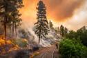
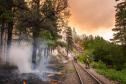
Steam & Excursion > 416 fire photosDate: 06/10/18 11:50 416 fire photos Author: stevelv Here are a few photos from today's Denver Post of the 416 fire which has been raging north of Durango, CO for over a week now. D&SNG is not running trains until at least the 17th as last reported.
  Date: 06/10/18 12:08 Re: 416 fire photos Author: dan is this a controlled burn here did it say?
Date: 06/10/18 12:27 Re: 416 fire photos Author: stevelv dan Wrote:
------------------------------------------------------- > is this a controlled burn here did it say? Yes, sorry. It is a controlled burn by Wyoming, Snake River and Idaho City hotshots to protect the D&SNG ROW. Looks like it's on the grade between Hermosa and Rockwood. Date: 06/10/18 13:07 Re: 416 fire photos Author: dan well a good place for a fire line, doubled in size yesterday it was said.
Date: 06/10/18 14:18 Re: 416 fire photos Author: wabash2800 Ok, I have no issue with the controlled burning but am wondering what the passengers will see when operations resume?
Victor A. Baird http://www.ersthwilepublications.com Date: 06/10/18 14:42 Re: 416 fire photos Author: callum_out It's not a "controlled burn", it's a "back fire" to reduce the fuel available to the
oncoming wild fire. Out Date: 06/10/18 15:27 Re: 416 fire photos Author: Cumbresfan wabash2800 Wrote:
------------------------------------------------------- > Ok, I have no issue with the controlled burning > but am wondering what the passengers will see when > operations resume? > > Victor A. Baird > http://www.ersthwilepublications.com In this area they will see burnt brush and charred tree trunks but the limbs above will be alive and green. Date: 06/10/18 17:05 Re: 416 fire photos Author: Frisco1522 How close is this getting to Durango?
Date: 06/10/18 17:53 Re: 416 fire photos Author: Margaret_SP_fan Frisco1522 Wrote:
------------------------------------------------------- > How close is this getting to Durango? https://inciweb.nwcg.gov/incident/5822/ This Inciweb site says the fire is 10 miles north of Durango, and this info was last updated "3 hours ago," which means the last update was ~3 pm Pacific Daylight Time today, Sunday, June 10, 2018. The area burning and burned is shown on the Inciweb map (at the top of the page) as diagonally striped. FWIW, "Percent of Perimeter Contained" is still given as 10%, even though size of the fire is now given today as 16,766 acres. That means those heroic firefighters have managed to steadily increase the number of feet that have been declared to be "contained," because the fire is much bigger than it was a week or two ago, so the perimeter is much larger. I learned last year that "contained" meas that the fire in any area said to be "contained" has been OUT for a minimum of 24 hours. Date: 06/10/18 20:02 Re: 416 fire photos Author: Hermosa45 The location of the pictures is near Pinkerton Siding. The fire crew is setting a backfire as they were trying to keep it from taking out Hermosa. This is by far the worst wildfire in La Plata County, CO in recent memory. The fire broke out near my home and spread rapidly through the pines and gamble oak. There was almost no moisture this winter. The cause of the fire is under investigation, but there is no doubt what started it. It started at 9:45AM on June 1.
This has been named the "416 fire" It split into two sections. One is running North and has traveled to within five miles of the Purgatory Ski Area. US 550 is closed at the top of Molas Pass. Cascade Village south is completely evacuated to Trimble Lane, six miles north of Durango. For anyone thinking there is no problem, it is my understanding that SILVERTON either will be placed on a pre-evacuation notice tomorrow, or as I type this they already have been. This means that with a reverse 911 call, be ready to leave. Ok, here's the southern fire. It has moved down into the upper reaches of Hermosa, about three miles from where it started. Hermosa and much of the northern Animas Valley has been evacuated. So far there are no structures lost. It forced the evacuation of Pine Acres Condos. For those of you who are familiar with Honeyville, it came down there too.This was the reason for the fire in the attached pictures.This fire has further split and crossed into the Hermosa Creek Wilderness area. It recently forced another 250 or so homes to be evacuated. There is only 10% containment. As of this morning, it had burned 18,600+ acres with no end in sight. Both June 1 trains are tied down in Silverton and they will remain there indefinitely. There will be no trains on June 17th. There is no place safe to run them. This fire is extremely dangerous--there are about 4000 home evacuated. There is an undertow of extreme anger in this area, and the reasons for it will become apparent in due time. So--it is headed for, in general terms, Silverton, possibly Rico and also the northwest end of Durango. There is no rain in sight for about six weeks, when the summer monsoon rains should arrive. We have been told that this fire could be around until the early winter snow puts it out. Keep the folks in Hermosa and the North Animas Valley in your thoughts--this is a Hell of a mess--it was unnecessary, that I can assure you of. I live about a quarter of a mile from where it started, about three quarters of a mile north of Pinkerton. A 727 slurry bomber laid down a load of slurry, coming in about 30 feet over my house. He cut the flames off and forced them up a hill away from us. We were evacuated for five days, and we are back home, buried in smoke, with fire still in evidence in the hills around the house. The authorities allowed us back because the property around is is burnt to a crisp. There are all the trappings of a large fire--smells, burning eyes, injured wildlife--well enough of this. For those looking for updated information, go to <Durango Herald.com.> or<416 fire in Southwestern Colorado> Al Chione Date: 06/11/18 08:58 Re: 416 fire photos Author: BAB Thanks for the very clear update on the event. It will take years as it always does after a fire depending on how much fuel load it had. The more load the longer for the ground to recover. I was in Montana last fall, there was no evidence one could see from a distance showing any recovery from a fire which had occurred several years earlier.
Date: 06/11/18 12:27 Re: 416 fire photos Author: czuleget Yes correct, it is called a back fire.
Date: 06/11/18 14:09 Re: 416 fire photos Author: Keystone1 These are fantastic photos of a horrible fire.
Date: 06/11/18 16:07 Re: 416 fire photos Author: Margaret_SP_fan Iinciweb says the fire is now at 22,131 acres. (That is the same size as a square almost 6 miles on a side!) There are now 851 people fighting this horrible fire.
I feel so sad for everyone affected by this horrible fire, and hope that no one gets hurt because of this awful fire, or loses anything irreplaceable. |