| Home | Open Account | Help | 326 users online |
|
Member Login
Discussion
Media SharingHostingLibrarySite Info |
Steam & Excursion > Such A Trim Locomotive And Her Train On A Beautiful Sunny Day!Date: 05/21/20 02:43 Such A Trim Locomotive And Her Train On A Beautiful Sunny Day! Author: LoggerHogger With white flags flying to signal she is pulling an extra train, Western Pacific 4-6-0 #77 seems right at home with her passenger train near Sunol, California. She has briefly stopped with her crew using the phone booth to check in before proceeding on.
Who wouldn't want to follow this train on this fine day? Martin Edited 3 time(s). Last edit at 05/21/20 04:15 by LoggerHogger. 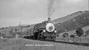 Date: 05/21/20 04:11 Re: Such A Trim Locomotive And Her Train On A Beautiful Sunny Day Author: GPutz Beautiful, as always, Martin. I think this may be just west of Sunol at the east end of Niles Canyon because of the through truss bridge in the background. Gerry
Date: 05/21/20 07:01 Re: Such A Trim Locomotive And Her Train On A Beautiful Sunny Day Author: elueck Simply gorgeous. It looks like the chasers in the cars thought so also.
Date: 05/21/20 07:36 Re: Such A Trim Locomotive And Her Train On A Beautiful Sunny Day Author: BAB Those cars date the pix very well both look new.
Date: 05/21/20 08:39 Re: Such A Trim Locomotive And Her Train On A Beautiful Sunny Day Author: zephyrus GPutz Wrote:
------------------------------------------------------- > Beautiful, as always, Martin. I think this may > be just west of Sunol at the east end of Niles > Canyon because of the through truss bridge in the > background. Gerry I think you are correct. I drive by here quite often. Great photo! Z Date: 05/21/20 09:05 Re: Such A Trim Locomotive And Her Train On A Beautiful Sunny Day Author: johnsweetser This was a California-Nevada Railroad Histoical Society excursion that ran on Aug 29, 1948. The train went to Stockton and then Bellota on the Stockton Terminal & Eastern.
For further details, see the thread from five years ago titled "Western Pacific #77 Ready To Depart Oakland Pier!", which includes the flyer for the trip (by the way, the date in the first post of that thread was incorrect). Posted from iPhone Edited 2 time(s). Last edit at 05/21/20 09:17 by johnsweetser. Date: 05/21/20 09:51 Re: Sunol Author: timz They seem to have stopped right on the west switch at Sunol
http://wx4.org/to/foam/sp/maps/perryETT/1948-05-30WP_Western36-SheldonPerry.pdf Date: 05/21/20 22:00 Re: Sunol Author: GoldenState timz Wrote:
------------------------------------------------------- > They seem to have stopped right on the west switch > at Sunol > > http://wx4.org/to/foam/sp/maps/perryETT/1948-05-30 > WP_Western36-SheldonPerry.pdf No siding or spur there. This is about MP 34.8, just east of the Alameda creek bridge and West of Sunol. I drive by here Daily. Rob Fremont, Ca Date: 05/21/20 23:09 Re: Sunol Author: danf I don't think there was a siding there either.
I do find it interesting to see that there was once a cantilever signal at that location. I believe I've seen one or two photos of it (if I remember right). It couldn't have been there long though. CTC was fairly new in 1948 and that bridge was replaced sometime later by a double set of searchlight signal masts that lasted until just about 10 years ago. As a side note... near that bridge seen in the distance. The old SP Sunol depot was moved there and used as a private residence for several decades. It was finally moved back to very near its original spot in Sunol by the PLA back in the late '90s (I have forgotten what year). Edited 1 time(s). Last edit at 05/21/20 23:12 by danf. Date: 05/22/20 00:03 Re: Sunol Author: Evan_Werkema danf Wrote:
> I don't think there was a siding there either. The link in timz's post points to a 1948 WP timetable that shows a 77-car capacity siding at Sunol at that time, and you can see one rail of the other track on the right side of the photo. There would have been no reason to install a cantilevered signal here if WP only had a single track. The siding and the cantilever were both gone by the time of the 1956 Butte-Plumas Express excursion that also did a photo stop here. The portion of the topo map in this old thread shows the siding and a house track on the WP at Sunol: https://www.trainorders.com/discussion/read.php?11,952076,952355#952355 Whether the siding was still in place in 1953 is an open question, but topo maps usually don't include multiple tracks that never existed at all. Date: 05/22/20 09:52 Re: Sunol Author: timz Looks like an "A" on the cantilever. But why does
the cantilever have an eastward signal? One problem: the topo map shows the siding on the south side of the main. Date: 05/22/20 18:37 Re: Sunol Author: danf There does appear to be a siding on the other side of the main. None of the topo maps I looked at show a siding. I looked at maps from before 1955. The one you found clearly shows a siding on the south side of the main (rather than the north side). Any WP maps from this area? That would also explain the cantilever and why it was later removed. It couldn't have been there for more than 10 years. According to Norman Holmes WP book, CTC was started in 1946 (East of oroville) and wasn't completed system-wide until January, 1953. Still, interesting to see searchlights at this early date (summer '48?).
Evan_Werkema Wrote: ------------------------------------------------------- > The link in timz's post points to a 1948 WP > timetable that shows a 77-car capacity siding at > Sunol at that time, and you can see one rail of > the other track on the right side of the photo. > There would have been no reason to install a > cantilevered signal here if WP only had a single > track. The siding and the cantilever were both > gone by the time of the 1956 Butte-Plumas Express > excursion that also did a photo stop here. > > The portion of the topo map in this old thread > shows the siding and a house track on the WP at > Sunol: > > https://www.trainorders.com/discussion/read.php?11 > ,952076,952355#952355 Edited 1 time(s). Last edit at 05/22/20 18:38 by danf. Date: 05/22/20 23:38 contour lines and maps Author: heatermason From the 1930's on, the contour intervals were drawn for topograhic maps based on aerial photography. Using Kelsh plotters and eyewear, with the photographs you actually create a 3D image and so finding the contours is easy. It is quite amazing to see; get it going and put on the specs and the buildings and trees all stand up, and the canyons deepen.
I point this out to say that the mapmakers were looking at actual photos and not just field notes so the map will reflect good information. The only issue will be the delay between the taking of the photographs and the map publication. Since the USGS and its predecessors did most of the topographic work, the aerial photographs are probably still out there, too. Timothy |