| Home | Open Account | Help | 333 users online |
|
Member Login
Discussion
Media SharingHostingLibrarySite Info |
Steam & Excursion > Chasing the #1309 by bicycle?Date: 06/20/22 17:58 Chasing the #1309 by bicycle? Author: P I just booked my tickets to ride the Western Maryland Scenic. We'll be staying the weekend and will have a free day Saturday after riding on Friday. I was considering bringing my bicycle since the GAP trail passes through. I thought about riding ahead of the train on Saturday to Helmstetters Cuve and watching the show. I have been searching unsuccessfully for a grade profile of the line and was wondering where the serious grade starts? From a vague profile that I've seen, it appears that the steep part doesnt start immediately at Cumberland. Has anyone done this? Any other advice/input from a cyclists perspective?
In 2020, I rode uphill from Frostburg to Myersdale and I'm not in a position to ride that steep of a route this year - unless perhaps to Brush Tunnel. Thanks for any tips! Date: 06/20/22 18:28 Re: Chasing the #1309 by bicycle? Author: CPR_4000 Here's a track chart of the Connellsville Extension: https://www.alphabetroute.com/wm/trackpdfs/WMTC1955CUM-CON.pdf
Looks like the westbound grade from City Junction varies from a bit less than 1 per cent to a fairly steady 1.75 per cent through Brush Tunnel to Frostburg. That's a little steeper than Frostburg to Deal. Edited 1 time(s). Last edit at 06/20/22 18:30 by CPR_4000. Date: 06/21/22 17:23 Re: Chasing the #1309 by bicycle? Author: P Thanks for the reply. Not a lot of bicyclists here, I suppose. Lol
I think I have adjusted my plan to get a vehicle ride to Frostburg and bike down to Cumberland from there, intercepting the 1309 on the way down the mountain. Proposed rendezvous points are either the west portal of Brush Tunnel or Helmstetters Curve. How are the views on the Curve? Need to pick a point and wait. Posted from Android Date: 06/21/22 17:33 Re: Chasing the #1309 by bicycle? Author: DTWilson This Help....?
 Date: 06/21/22 17:58 Re: Chasing the #1309 by bicycle? Author: P DTWilson Wrote:
------------------------------------------------------- > This Help....? > I was looking for a graph that showed a representation of the steepness at various points along the line. I remember seeing one when I rode from Frostburg west, but can't remember if it was a handout I got along the trail, or what. A search yesterday uncovered a graph, but unfortunately wasn't very detailed in terms of seeing what the grade is at specific points. Posted from Android Date: 06/21/22 20:24 Re: Chasing the #1309 by bicycle? Author: CPR_4000 P Wrote:
> I was looking for a graph that showed a > representation of the steepness at various points > along the line ... seeing what the grade is at specific points. The track chart I linked to above shows exactly that. The grade profile is near the botton of each page. Here it is again: Connellsville Extension Track Chart Clickable Link Edited 2 time(s). Last edit at 06/22/22 08:52 by CPR_4000. Date: 06/22/22 05:27 Re: Chasing the #1309 by bicycle? Author: DavidP The train moves surprisingly fast. To pace it you would need to be Lance Armstrong on steroids....oh wait, that's a thing?
The curve has the longest sustained views...I positioned myself in a field just above the farm lane that crosses the tracks. You could catch him coming out of the tunnel, but then probably would want to wait a few minutes for the smoke to clear before continuing your ride downhill. Dave Date: 06/22/22 09:21 Re: Chasing the #1309 by bicycle? Author: P CPR_4000 Wrote:
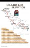
------------------------------------------------------- > P Wrote: > > > I was looking for a graph that showed a > > representation of the steepness at various > points > > along the line ... seeing what the grade is at > specific points. > > The track chart I linked to above shows exactly > that. The grade profile is near the botton of each > page. Here it is again: > Connellsville Extension Track Chart Clickable Link That's awesome. Thank you. That's helpful. What I was thinking was something like the attached that is more visual than scientific - but with more location points listed (like the track chart). Date: 06/23/22 14:51 Re: Chasing the #1309 by bicycle? Author: gregscholl I was just there last weekend, and my feel is that its steeper toward the top. We got our best shots nearer to Frostburg. I would go for Brush Tunnel without hesitation. If you get a good video shot and I like it for a dvd, I will give you a free one!!! Helmstetters Curve is easily accessible by highway, and where many bikers leave their cars. Its not hard to see, but Brush is. Its too far for me to walk. I did use my walker some at a couple spots to get away from crossings!!! That way I have a seat too!
Greg |