| Home | Open Account | Help | 309 users online |
|
Member Login
Discussion
Media SharingHostingLibrarySite Info |
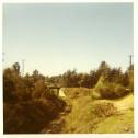
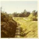
Nostalgia & History > So. Cal. Where was/is it?Date: 08/21/10 10:10 So. Cal. Where was/is it? Author: UPNW2-1083 From January 1972. What railroad, what line, what city?-BMT
  Date: 08/21/10 10:20 Re: So. Cal. Where was/is it? Author: Fredo UPNW2-1083 Wrote:
------------------------------------------------------- > From January 1972. What railroad, what line, what > city?-BMT Looks like Fullerton or possibly where you found those 3 over 50 yearolds acting like the Budweiser Frogs! Date: 08/21/10 10:29 Re: So. Cal. Where was/is it? Author: UPNW2-1083 Fredo Wrote:
------------------------------------------------------- > UPNW2-1083 Wrote: > -------------------------------------------------- > ----- > > From January 1972. What railroad, what line, > what > > city?-BMT > > Looks like Fullerton or possibly where you found > those 3 over 50 yearolds acting like the Budweiser > Frogs! Close, Fredo, and not a Bud frog in sight.-BMT Date: 08/21/10 10:31 Re: So. Cal. Where was/is it? Author: rehunn That would be the PE Fullerton line of the UP Fullerton line, maybe,
some where down around Bastanchury?? Date: 08/21/10 10:51 Re: So. Cal. Where was/is it? Author: UPNW2-1083 rehunn Wrote:
------------------------------------------------------- > That would be the PE Fullerton line of the UP > Fullerton line, maybe, > some where down around Bastanchury?? Close enough, Rich. After all these years the memory is fading but IIRC these were taken off of Harbor Blvd. and I think that's La Habra, but I could be wrong. Anyone know if it's still being used? I haven't run the Anaheim branch since 1989.-BMT Date: 08/21/10 12:46 Re: So. Cal. Where was/is it? Author: africansteam Possibly Harbor Boulevard in Fullerton?
Cheers, Jack 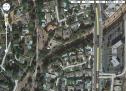 Date: 08/21/10 13:16 Re: So. Cal. Where was/is it? Author: rehunn Hmm, the was a spot after Fullerton Jct (La Habra) where the line south went into a cut, so it
was either on that side or the other side. Mid sixties there was a housing development (yuk-yuk) just south of where this spot might be that I wandered through. Incredible places, couldn't be that expensive until I asked-$55K in 1964, was like a $1.2M now, but would have been sweet because the one I wanted pretty much had a view of the line between whichever of the two cuts pictured. Date: 08/21/10 14:10 Re: So. Cal. Where was/is it? Author: colehour The UP line was still operating, IIRC, when I left Southern California in 2001. One of the customers was a canning plant (Hunt's?) if I'm not mistaken. Did it once go all the way into Orange?
Interestingly enough, there were once three lines that went through Sunny Hills, the site of a big citrus packing plant. The PE Fullerton branch, mentioned in a previous post (a great trip on a bike, or at least it used to be), the UP line, and the Santa Fe all served the plant. I never figured out where the ATSF track was, unless it simply ran parallel to the UP or maybe they had trackage rights. Somewhere I have a file with a map and even an aerial photo -- if I can find them. Edited 1 time(s). Last edit at 08/21/10 14:30 by colehour. Date: 08/21/10 14:40 Re: So. Cal. Where was/is it? Author: colehour Here's a map of the lines serving Bastanchury/Sunny Hills. I am also attaching the aerial photo of the packing plant I mentioned but, without the explanation that went with it (now lost), I'm afraid I can't make much sense of it.
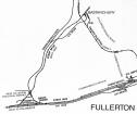 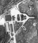 Date: 08/21/10 15:58 Re: So. Cal. Where was/is it? Author: MyfordBrowning The photo is from Harbor Blvd looking at the UP Anaheim Branch going under the girder bridge of the PE's Fullerton Line. The PE line was abandoned in 1962 and the PE obtained track rights on the UP to Fullerton (later between Anaheim and Fullerton). Neither the UP or PE lines went to Tustin, although both lines had plans to build track to Tustin. The main customer in the area, not counting the packing houses at Sunny Hills was Hunts who processed tomatoes at the point that the UP crossed the Santa Fe Mainline (Basta). Hunts was purchased by Cargil and they still have a vegetable oil facility at the site of the former Hunts plant. Until recently the UP the the sole switcher of the Cargil plant, but recently the BNSF has been doing most of the switching there. The Santa Fe spur to Sunny Hills (the Bastanchury Spur)was basically on the alignment of what is now Bastanchury Road. The AT&SF spur went under the UP just south of the present trestle over Brea Creek.
Cliff Date: 08/21/10 16:51 Re: So. Cal. Where was/is it? Author: rehunn I think I said that though not nearly as well as you Cliff. As someone born and raised in LA some of these
pictures don't even seem real. How could some of these areas change so much in a relatively few years? Date: 08/21/10 17:29 Re: So. Cal. Where was/is it? Author: colehour Thanks for the information, Cliff. I rather thought that the ATSF alignment might have followed what is now Bastanchury Road.
It is indeed amazing that L.A. and Orange Counties went from being among the most productive agricultural counties in the USA to hosting the sprawling suburbs of today. When I moved to Southern California in 1973 there were still some orange groves in and and around Pomona and Claremont. One had a sense of what much of the county must have been like not that many years before. Date: 08/22/10 16:49 Re: So. Cal. Where was/is it? Author: David.Curlee My grandparents lived 400 feet behind you in the first photo. Until a year or two ago, UP came down the branch 5 days a week to switch Cargill. It's very sporadic now because BNSF has the bulk of the business. The old UP Anaheim Branch now connects to the BNSF at Basta where the diamonds used to be.
|