| Home | Open Account | Help | 341 users online |
|
Member Login
Discussion
Media SharingHostingLibrarySite Info |
Nostalgia & History > First Transcontinental RR & Highway on DonnerDate: 05/20/19 15:44 First Transcontinental RR & Highway on Donner Author: BoilingMan This is kind of a jumble of criss-crossing histories. I hope it comes off as somewhat coherent...
The first railroad across the country was, of course, completed in 1869 (there was something in the news about that the other day- perhaps you saw it?). A bit less known was the first coast to coast highway in 1913, the Lincoln Highway. Anyway, the RR and Highway followed similar routes in the West and crossed paths I-don't-know-how-many times. This is probably one of the lesser know crossings: Near Secret Town on Donner. Secret Town is also one of the spots that caught the attention of photographers in the 1860's because of the impressive trestle the CPRR built here (Now a fill). Photo 1. Amtrak's #6 about to cross the Lincoln Highway. This underpass dates back to the Teens or Twenties and was built to provide for the LH. Photo 2. A crop of the above photo: note the "L" on the red, white, and blue background marking the old Lincoln Hwy. Photo 3. A view of the Secret Town Trestle from the 1860's. The photographer (probably Alfred A Hart) was up on top of the cut #6 is passing thru in my photo. Did all of that make any sense? SR 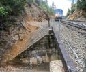 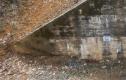 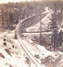 Date: 05/20/19 20:53 Re: First Transcontinental RR & Highway on Donner Author: Railpax71 Pictures from the tunnel 1 portal looking toward Donner Lake show the original highway traversing the summit. Historic photos when my family first transited to Grass Valley. I did one from the bridge with my 8x10 camera which I have to scan in full glory or partial. I wish there was hight resolution so you could zoom in and look around.
Date: 05/20/19 22:43 Re: First Transcontinental RR & Highway on Donner Author: coach Yes, yes, yes!! You can still drive to this underpass, although the locals don't like it. But it's history! After you get to the underpass, you can look up the old road grade where it then crosses current I-80. AND, the old road and cut where it crosses I-80 can be seen and driven on the south side of I-80. Then the road starts to meander again, before ending up in Alta. In Alta, a section of the ORIGINAL road cuts up and over a small hill, avoiding the current intersection below Alta. That original road potion is now someone's private property / driveway.
Ive traced the road extensively over Donner, including over the summit. Took some friends, who couldn't believe the history. Date: 05/21/19 01:28 Re: First Transcontinental RR & Highway on Donner Author: BoilingMan Yes, that’s a pretty good description of the route through my neighborhood. If you’re up here following the LH, don’t miss the replica Lincoln Hwy marker someone put at the end of their driveway just east of Gold Run. Kinda cool.
SR I’ve driven the route (as best as one can) to Salt Lake City. The section between Ely NV and Tooele UT is the most remote country I’ve ever passed through- 8hrs of steady driving and never encountered a single car. Date: 05/25/19 11:23 Re: First Transcontinental RR & Highway on Donner Author: jridge Lincoln Highway Association has a nice online interactive map of the road superimposed on googlemaps if anyone wants to follow it. Site is:
https://www.lincolnhighwayassoc.org/map/ Jeff |