| Home | Open Account | Help | 268 users online |
|
Member Login
Discussion
Media SharingHostingLibrarySite Info |
Nostalgia & History > E.K. Muller: Visitacion Point in 1955Date: 07/06/20 02:05 E.K. Muller: Visitacion Point in 1955 Author: Evan_Werkema In photobob's thread on Sunday 7/5, folks were asking about SP's Bayshore icing facility located geographic west of the main line, and also about the hill opposite it at Visitacion Point at the south end of SP's Bayshore Yard near San Francisco, CA. On June 9, 1955, E.K. Muller spent an overcast morning at Bayshore shooting whatever happened by, including the diesel-powered trains he would soon come to shun. The three views below courtesy the Western Railway Museum Archives illustrate the scene around Visitacion Point at that time.
1) The still-extant tunnel under the Bayshore highway (out of frame to the left) was originally for road rather than rail traffic. The road connected to an overpass which spanned the SP mains at the cut through the hill at Visitacion Point. SP GP9 5603 leads commute train 112 toward San Jose through the cut and under the bridge. 2) Stepping back a bit further, the SP icehouse is visible to the left as Alco S-4 1485 rattles past. 3) Muller climbed the now-gone hill east of the tracks to record this view of the westbound Lark behind E7 6003 with the icehouse to the right. The hindquarters of a dump truck can be seen on the overpass on the right edge of the frame, and Visitacion Tower is just visible in the distance near the left edge. 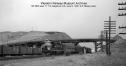 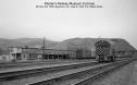 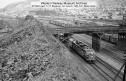 Date: 07/06/20 04:50 Re: E.K. Muller: Visitacion Point in 1955 Author: refarkas First-class historic images.
Bob Date: 07/06/20 07:06 Re: E.K. Muller: Visitacion Point in 1955 Author: dmaffei What a great way to spend a foggy Sunday. Interesting to see what this location looked like 20 years before I spent time railfanning the area. As others mentioned, the brick ice house still stands today. Thanks for sharing these.
Date: 07/06/20 07:29 Re: E.K. Muller: Visitacion Point in 1955 Author: photobob Date: 07/06/20 08:38 Re: E.K. Muller: Visitacion Point in 1955 Author: FiveChime Great finds Evan! I don't suspect that the industrial trackage through that little tunnel to the west was installed yet.
Regards, Jim Evans Date: 07/06/20 09:01 Re: E.K. Muller: Visitacion Point in 1955 Author: Ritzville What an interesting look at the SP! Very enjoyable! About the same time my uncle used to take me to the San Bruno Station to watch the steam parade in the late afternoon.
Larry Date: 07/06/20 09:08 Re: Visitacion Point 1955 Author: timz The overpass must have been built for trucks
carrying fill for US 101, then being built across the Bay. Anyone know where the fill came from? Date: 07/06/20 10:26 Re: Visitacion Point 1955 Author: phthithu timz Wrote:
------------------------------------------------------- > The overpass must have been built for trucks > carrying fill for US 101, then being built across > the Bay. Anyone know where the fill came from? I remember concluding that the bridge over the SP at Visitacion was a haul road from the quarry on San Bruno Mountain right above the future site of the Crocker Industrial Park. That was based on an aerial photo I think I got from Framefinder but their site is down at the moment so I can't go check. 1946 aerials probably is the one I need. Date: 07/06/20 10:35 Re: Visitacion Point 1955 Author: phthithu Thanks Evan for sharing these great informative images. Plenty of traffic at the icing facility then. Would they have iced empty reefers that were going to Watsonville, say, later in the day? It looks like these are empties given the open hatches, but I don't know how reefers work...
Edited 1 time(s). Last edit at 07/06/20 10:36 by phthithu. Date: 07/06/20 11:16 Re: Visitacion Point 1955 Author: phthithu Here's a September 1956 aerial from the UCSB Special Research Collections site. This is a direct download link, click on it and the download will start. It's kind of a big one: http://mil.library.ucsb.edu/ap_images/gs-vlx/gs-vlx_1-91.tif
And attached is an attempt at a mosaic of this image. I made three screen shots and hope they stitch together here. I think you'll see the haul road going directly out to highway 101, as TimZ surmised. And you can follow it up to quarry in the hills as well. But if you look around, it looks like some parts of the hill just west of Bayshore Blvd might have been used to provide 101 fill. Downloading the image is best way to go though.... Edited 2 time(s). Last edit at 07/06/20 11:19 by phthithu. 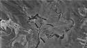 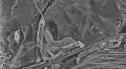 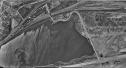 Date: 07/06/20 11:23 Re: Visitacion Point 1955 Author: phthithu Here's 1946 for further comparison's sake. You can see the full historic extent of Visitacion Point. This image is from USGS Earth Explorer website. Looks like a great site for a tank farm, as opposed to much of the rest of the land in the area!
Edited 1 time(s). Last edit at 07/06/20 15:32 by phthithu. 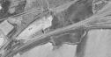 |