| Home | Open Account | Help | 323 users online |
|
Member Login
Discussion
Media SharingHostingLibrarySite Info |
Nostalgia & History > Best Chicago map ever (says 1950)Date: 05/27/23 14:20 Best Chicago map ever (says 1950) Author: timz Only way to improve it would be color.
https://collections.lib.uwm.edu/digital/collection/agdm/id/6932/rec/19 Date: 05/27/23 14:44 Re: Best Chicago map ever (says 1950) Author: TAW Chicago Switching District map. I have a paper copy and no wall to put it on. jpg jhas now been suitably filed. Thanks.
TAW Date: 05/27/23 14:47 Re: Best Chicago map ever (says 1950) Author: goneon66 awesome map. thanks for posting...........
66 Date: 05/27/23 14:50 Re: Best Chicago map ever (says 1950) Author: Lackawanna484 The Indiana Harbor Belt sold a detailed wall map of Chicagoland junctions, lines, yards, shippers, etc back in the 1980s.
Who had rights on which lines, many colors, and details, etc. Posted from Android Date: 05/27/23 15:28 Re: Best Chicago map ever (says 1950) Author: RuleG The inset for Downtown Chicago is amazing!
Date: 05/27/23 16:28 Re: Best Chicago map ever (says 1950) Author: TAW Lackawanna484 Wrote:
------------------------------------------------------- > The Indiana Harbor Belt sold a detailed wall map > of Chicagoland junctions, lines, yards, shippers, > etc back in the 1980s. > > Who had rights on which lines, many colors, and > details, etc. > It was really cool, but way too much had already been ripped out for my desire. TAW Date: 05/27/23 16:34 Re: Best Chicago map ever (says 1950) Author: phthithu Geez it would be hard to be a railfan in 1950 Chicago. A lot to either memorize or simply resign to being ignorant of!
Date: 05/27/23 17:32 Re: Best Chicago map ever (says 1950) Author: irhoghead Thank you for sharing this!
Date: 05/27/23 19:38 Re: Best Chicago map ever (says 1950) Author: ghemr timz Wrote:
------------------------------------------------------- > Only way to improve it would be color. > > https://collections.lib.uwm.edu/digital/collection > /agdm/id/6932/rec/19 I have a similar map except mine is dated 1935! Perhaps I should look into preserving and sharing it via a website or some other means........ For the Chicago history buffs: the 1950 map shared by Timz names ALL of Yard Center (C&EI/Dolton) as such. On my version the north half of the yard is named Yard Center----the southern half is named Haney Yard. Edited 1 time(s). Last edit at 05/27/23 20:29 by ghemr. 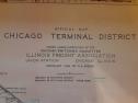 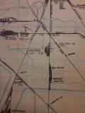 Date: 05/28/23 01:03 Re: Best Chicago map ever (says 1950) Author: Odyssey Yes, if at all possible to get the map
scanned please do. The more paper maps that can be preserved as digital scans the better ... Given that the boomer generation is beginning to pass on in greater numbers the historic documents that they might have as paper copies need to be preserved in a digital format and archived online. The boomer generation is a key link in preserving the detailed history of the late 1880's till the 2020's ... Odyssey Evergreen, CO Date: 05/28/23 21:31 Re: Best Chicago map ever (says 1950) Author: Seventyfive A thousand " thank yous " for posting the digital version of that great map. Like Tom,
I have no where to hang my paper copy. Mine came from, of all places, the office of a warehouse manager at a soap factory from which it was being discarded. Zooming in on all the incredible details on a computer screen is much easier than standing at a wall with a magnifying glass. Within minutes I discovered long-gone tracks that I never noticed on my paper copy. Date: 05/29/23 20:48 Re: Best Chicago map ever (says 1950) Author: AmHog Can anyone tell what the NYC(C) & NYC(M) are?
Date: 05/29/23 22:39 Re: Best Chicago map ever (says 1950) Author: TAW AmHog Wrote:
------------------------------------------------------- > Can anyone tell what the NYC(C) & NYC(M) are? > There were three flavors of NYC in Chicago: Michigan Central (called 'the Michigan'), Lake Shore & Michigan Southern (called 'the Lake Shore'), and Chicago, Indiana & Southern (never heard a named other than CI&S). Guessing M for the Michigan. The C, not sure. I need to see it in context. TAW Date: 05/30/23 01:22 Re: Best Chicago map ever (says 1950) Author: Seventyfive The NYC (C) likely stood for the Big Four route, the former Cleveland, Cincinnati, Chicago and St. Louis Railway.
It used the Illinois Central from Central Station, Chicago to Kankakee, Illinois and then onto its own rails. Also, the NYC (W) probably refered to their Western Division, as that trackage was so named from Elkhart to Chicago. Edited 1 time(s). Last edit at 05/30/23 09:50 by Seventyfive. Date: 05/30/23 08:47 Re: Best Chicago map ever (says 1950) Author: IC1038west Good map with the softened background locations for easy reference. Thanks for sharing!
|