| Home | Open Account | Help | 373 users online |
|
Member Login
Discussion
Media SharingHostingLibrarySite Info |
Nostalgia & History > 1932 Aerial Photo--MysteryDate: 11/06/04 16:38 1932 Aerial Photo--Mystery Author: nycman Where is this? Can anyone identify any of the landmarks?
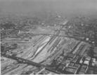 Date: 11/06/04 16:47 Re: 1932 Aerial Photo--Mystery Author: Ray_Murphy This is central Los Angeles. The bridge at the bottom of the picture is the 1st Street Bridge, and the bridge in the middle is the 4th Street Bridge. The view is towards the south. The LA River was prone to floods, but it took a disasterous 1938 flood to start the major concrete channelization project which made the river like it is today.
I took a number of photos from the 1st street bridge one very hot day in 1984 or so. Apparently I walked through a very dangerous neighborhood to get there, but it was so hot nobody was out on the streets. Needless to say, I learned about all this later. Ray p.s. That same day, and from that bridge, I also watched helicopters fighting a brush fire on the east side of the river (along the embankment above the freeway that now goes along the river) Date: 11/06/04 17:57 Re: 1932 Aerial Photo--Mystery Author: SurflinerHogger The major yard on this side of the river is the Santa Fe 1st St. yard with the Grand Depot on the near side of the yard. Lots of movies made there in the twenties and early thirties.
Date: 11/06/04 19:20 Re: 1932 Aerial Photo--Mystery Author: nycman You guys are good. This photo is the property of my friend Ray Travis, ATSF retired. The photo is, as Ray Murphy stated, looking from N to S in LA. The bridges are 1st, 4th, 6th, 7th streets and Olympic Blvd. The Santa Fe station is foreground right side, and the big buildings way off in the smoggy distance are Sears.
Date: 11/07/04 01:18 Re: 1932 Aerial Photo--Mystery Author: Ed_Gyptian You can see the big white Sears Buildings in a lot of the Redondo Junction shots, and maybe in some of the north end of the trench shots.
As noted the river bed has been concreted and you see it all the time in tv and movies. Also, as you can see smog is not a new thing. Date: 11/07/04 09:46 Re: 1932 Aerial Photo--Mystery Author: fboggle The inversion layer was noted by the first Spanish settlers to the LA Basin. They noticed that the smoke from fires (the brush in Southern California spontaneously combusts -- it is a biological adaptation) would rise and then flatten out (make a mushroom) in the absence of wind.
We Angelenos call that "denser than fresh" air. Date: 11/08/04 19:49 Re: 1932 Aerial Photo--Mystery Author: SurflinerHogger The MTA Red Line Subway yards now occupy most of what was the 1st. St. yard. The two long buildings on the right are the Santa Fe freight houses and offices. BNSF still owns most of what's left between SCRRA track four (old AT&SF Main 2) on the West Bank and the MTA property. They use it to store bare tables (empty TOFC).
|