| Home | Open Account | Help | 312 users online |
|
Member Login
Discussion
Media SharingHostingLibrarySite Info |
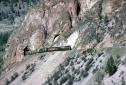
Canadian Railroads > MLW Monday-My Tunnel ShotDate: 03/20/17 15:59 MLW Monday-My Tunnel Shot Author: arwye High above Highway 12 between Indian Reserve and Glenfraser BCR continued its climb out of the canyon, using a short tunnel to deal with this rock face. BCR 710 & CN 3239 are southbound on June 7, 1980. Richard Yaremko
 Date: 03/20/17 17:09 Re: MLW Monday-My Tunnel Shot Author: kgmontreal The terrain is so crazy it hardly looks real.
KG Date: 03/20/17 19:48 Re: MLW Monday-My Tunnel Shot Author: hoggerdoug Richard, a wonderful shot and true view of the difficult terrain on the "Kelly Lake Hill", tunnel located at mile 168.4, one of three short tunnels on the grade.
And yes KG, it was "The terrain is so crazy it hardly looks real." IMHO almost insane place to build a railway. Not wishing to hijack the post, I have attached three images taken in the tunnel, south bound on the Rocky Mountaineer, July 2008. Images are somewhat exaggerated with a little telephoto lense. Doug 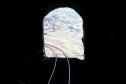 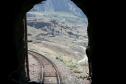 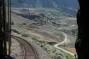 Date: 03/20/17 20:03 Re: MLW Monday-My Tunnel Shot Author: feclark Why am I wasting my time shooting on the Wainwright Sub (rhetorical question; you shoot what you can when you can). But seriously, this one makes me want to put the camera away. The power is perfect, the light gorgeous, and the attention to detail is perfect. You snapped just before the pole, but didn't shoot between the next pair, because this is where the green pops off the white rock face. Superb in every way.
Fred Date: 03/21/17 05:33 Re: MLW Monday-My Tunnel Shot Author: refarkas Great image showing how hard mountain-railroad building and operation is.
Bob Date: 03/21/17 09:32 Re: MLW Monday-My Tunnel Shot Author: eminence_grise Sometime between the late 1700's, when Simon Fraser passed through this area, and the 1850's , when this was the "Overlanders" route to the Cariboo gold fields, a massive rock slide came down and dammed the Fraser River at this location. The Fountain First Nation members wisely vacated the area, and warned the Lillooet and Lytton bands to do the same.
Fraser was an explorer who made detailed maps and notes.He spent a winter with the Lytton First Nation, whose members showed him how to scale the canyon walls to reach tidewater. He made accurate counts of the settlements he passed through. In the 1920's, when the first comprehensive Canadian census was conducted, it was noted that the settlements which Fraser enumerated were much smaller. At the time, this was attributed to smallpox and other European diseases. An ongoing research project has revealed that the reason for the huge decline in population was the fact that the First Nations people left the area in a hurry before the "dam" broke and didn't come back. A similar slide blocked the Thompson River near Spences Bridge in the same era. Without a written language, the Salish people relied on "tellings" where the elders passed on their history verbally. Although sometimes spoken as a parable, and modified by Christianity, the accounts of the Fraser River exodus are amazingly accurate. |