| Home | Open Account | Help | 376 users online |
|
Member Login
Discussion
Media SharingHostingLibrarySite Info |
Canadian Railroads > Dawson the Hard WayDate: 07/18/17 09:17 Dawson the Hard Way Author: loleta Some photos are just easier than others; here are three of the others.
1. Train 579 on the Dawson Creek Sub. (former BC Rail) south of Foss. You can see the railroad's bridge over the Pine River in the distance at right. About two miles of walking, cuts, bruises, and a sprained rotator cuff. 2. 578 crossing the Kiskatinaw River. Two miles of high-speed walking to beat the train here, two much slower miles back. 3. 578 near Sundance. 3 miles of walking and a close encounter with a large, three-legged bear: while a mile and a half from the safety of my truck! Loleta Fernbridge Edited 1 time(s). Last edit at 07/18/17 10:17 by loleta. 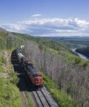 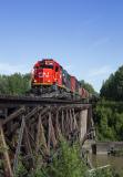 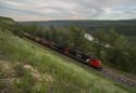 Date: 07/18/17 09:31 Re: Dawson the Hard Way Author: Milepost_130 Wow! I respect the effort required to record these scenes. Thanks for posting.
Date: 07/18/17 10:06 Re: Dawson the Hard Way Author: PasadenaSub Very nice set of images, thanks for making the effort to get them.
Rich Date: 07/18/17 10:30 Re: Dawson the Hard Way Author: SD45X 👍👍
Date: 07/18/17 11:17 Re: Dawson the Hard Way Author: hoggerdoug Nice images, thanks for the effort and posting of your recent trip along the BC Rail. Perhaps "Loleta" could open a business of "guided and obscure" photo locations along BC Rail. From the sounds of it could incorporate some wildlife viewings as well.
Some additional information, Pine River bridge is located at mile 16.6. Kiskatinaw River bridge mile 46. I recall the bridge is unusual, a "Howe through truss"?? Other trivia at mile 47, is "Campbells Pass" named after Rik "Hollywood" Campbell, had a nasty upset of cars there. At one time the Dawson Creek sub was "east and west" were as all other BCR directions were north & south. Eventually at a time table change, the direction was changed to north-south. My first experiences on the Dawson Creek 1973, it was a 6 day a week job out of Chetwynd. Mid morning departure and the 59 mile, 3 hour jaunt to Dawson Creek. Drop our train, have a bite to eat, pickup the train the yard crew built and head back to Chetwynd. On Sunday, we would have to spot the TOFC ramps because there was not yard crew available. Doug Date: 07/18/17 13:29 Re: Dawson the Hard Way Author: railfan Nice shots and worth the walking to get them!
JT Date: 07/18/17 14:05 Re: Dawson the Hard Way Author: trainjunkie I've been near all of these locations many times but will never get shots like these for the reasons the OP stated. I'm exhausted just reading about it. LOL!
Nice work! Date: 07/18/17 20:34 Re: Dawson the Hard Way Author: TCnR Great stuff, thanks for the explanations and a current look at the surrounding foliage. I doubt the BCR book has the angle with the vines growing up the trestle.
t4p. Date: 07/19/17 15:47 Re: Dawson the Hard Way Author: loleta hoggerdoug Wrote:
------------------------------------------------------- > Some additional information, Pine River bridge is > located at mile 16.6. Kiskatinaw River bridge mile > 46. I recall the bridge is unusual, a "Howe > through truss"?? > > Doug Here's a better photo of the bridge from August 2016. - L.F. 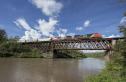 Date: 07/19/17 18:23 Re: Dawson the Hard Way Author: tsokolan Great shots! Thanks for going the extra mile to capture some amazing views of the Dawson Creek Sub!
-Trevor Date: 07/20/17 17:04 Re: Dawson the Hard Way Author: 3rdswitch Outstanding effort and results!
JB Date: 07/24/17 14:22 Re: Dawson the Hard Way Author: ns1000 Very nice..!!
|