| Home | Open Account | Help | 327 users online |
|
Member Login
Discussion
Media SharingHostingLibrarySite Info |
Canadian Railroads > Laggan Sub - Dec 14Date: 12/14/17 11:56 Laggan Sub - Dec 14 Author: KickingHorse No such thing as "High Noon" at this time of year. Even at 11:10 the shadows of the trees are way longer than the trees are tall. On a sunny day it's tough to catch a train in the short time that any spot is actually sunny.
Eastbound grain empties at Cougar Creek. 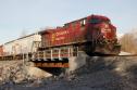 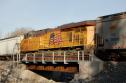 Date: 12/14/17 14:45 Re: Laggan Sub - Dec 14 Author: cn6218 Is that the bridge that was taken out by a derailment a few years ago. Just west of the Banff station?
GTD Date: 12/14/17 15:39 Re: Laggan Sub - Dec 14 Author: KickingHorse No. That was Forty Mile Creek which is just west of Banff Station. Cougar Creek is in Canmore.
Cougar Creek is normally dry down this far but it was the one did the most damage in the 2013 floods. This bridge is only a couple of years old. It replaced a bunch of culverts that couldn't handle the material that washed down when the rain was heavy. In the pic below, this is early in the flooding. We put 2 more excavators in there and still couldn't keep the culverts open. It ended up taking out about 1000' of track and the mainline was closed for a few days. The flood took out the Trans Canada Highway (upstream) as well. Edited 1 time(s). Last edit at 12/14/17 15:42 by KickingHorse. 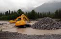 Date: 12/14/17 15:56 Re: Laggan Sub - Dec 14 Author: KickingHorse Here's a shot from Sep 2014 that shows the culverts. The CSP culverts were concreted in place so they actually survived the flood. The coated steel pipes were added after the flood while the roadbed was being rebuilt.
 Date: 12/14/17 16:06 Re: Laggan Sub - Dec 14 Author: cn6218 Was the problem volume of water, or large stuff (tree branches), that the culverts couldn't handle?
BTW, I seem to recall reading somewhere that no matter how it was constructed, any structure less than a certain span (10 or 20 feet?) was considered a "culvert" by the engineering types. I was looking at the recent span you posted above and noticed that the concrete of the abutments extends up to the top of the main girders. Does that help prevent damage from snowplows and derailed equipment? GTD Edited 1 time(s). Last edit at 12/14/17 16:15 by cn6218. Date: 12/14/17 16:30 Re: Laggan Sub - Dec 14 Author: KickingHorse The problem is the gravel. Cougar Creek flows over an alluvial fan which it made after the Bow valley glacier melted about 8,000 years ago. When the CPR came through in 1883, there was no Canmore of course. In the 1970s, Canmore expanded onto the alluvial fan. Prior to this, during heavy rains combined with snow melt, Cougar Creek could divide into multiple channels. Now there are residential areas bordering the creek all the way up to the canyon it comes out of so it is restricted to just this one channel. There are a number of culverts to the east of this location that haven't seen any real flow in years.
So with all that gravel-laden water having nowhere to go to relieve the force it has, it goes all the way to the bottom. The creek bed levels out right here so the gravel would start settling out and plug the culverts. Date: 12/14/17 16:43 Re: Laggan Sub - Dec 14 Author: KickingHorse cn6218 Wrote:
------------------------------------------------------- > I was looking at the recent span you posted above > and noticed that the concrete of the abutments > extends up to the top of the main girders. Does > that help prevent damage from snowplows and > derailed equipment? > I am a civil engineer. While that might be correct, my first thought for this contemporary design would be to help prevent a washout behind the abutments. In the spring runoff this year, the water did come up to near the bottom of the girders. And this years runoff wasn't much compared to other years. |