| Home | Open Account | Help | 375 users online |
|
Member Login
Discussion
Media SharingHostingLibrarySite Info |
Canadian Railroads > Exploring the Takla Sub via Bing Maps - questionDate: 08/12/19 16:39 Exploring the Takla Sub via Bing Maps - question Author: roustabout A couple images I extracted from my exploration of the Takla Sub online today and I would appreciate HoggerDoug and others chiming in here with corrections or opinions.
#1 appears to to be Lovell and the reload that was used during the last major operations on the line. Interesting that Bing Maps still shows something of a camp here (although there's no idea of how old the image is). I think #2 is the end of the line at Minaret as it is adjacent to Minaret Creek. A bit of a reload here but no wye. 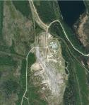 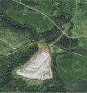 Date: 08/12/19 16:48 Re: Exploring the Takla Sub via Bing Maps - question Author: TCnR Both of these locations are discussed in Dale Sanders Book with ground level photos. Apparently Mineret was a simple spur off the mainline, they had to back the train a number of miles which caused them to keep a caboose for the reverse move.
The bing images look a lot like the ones on google, not the same image but similar info. + fwiw, on another post I mentioned that you can use Google Streetview on a couple of grade crossings near Fort St. James. Doesn't show much else than the rail war for that day, also lots of brush. Edited 1 time(s). Last edit at 08/12/19 16:54 by TCnR. Date: 08/13/19 11:16 Re: Exploring the Takla Sub via Bing Maps - question Author: hoggerdoug At Lovell there was a large sawmill, mostly rough cut lumber shipped out as well as green ties and I can't recall what year it shutdown. Anyhow there was a large ground camp there for the mill workers, think they were in for seven days and out for seven days, alternating mill crews. The railway used to operated a Budd car to bring the workers in and out. The buildings you see are perhaps the old ground camp accomodations and was also used by the log train crews. The mill structure and machinery have been removed. All ancient history now. Years ago switcher crews operated from Fort St. James to Leo Creek (mile 151.5) and return to Fort St. James. There was a switcher crew based at Leo Creek that was advertised as the Bulkley House Switcher. They would run north to Lovell and switch the mill there and what other work there was on line and return to the camp at Leo Creek. Same scenario, two crews working alternate weeks, 7 days on 7 days off.
I never did quite understand how the log trains were crewed and operated. They were a three man crew, Conductor, Brakeman and Engineer. Long trips from Fort St. James to Minaret or Mosque, working 6 or 7 days and then 7 or so days off. Two alternating crews. I did couple of familiarization trips north of Leo Creek, it was all at night and a long time ago. September of 2005 I worked a Geometry car from North Vancouver including all of the Stuart and Takla subs and then up to Chetwynd. On the Takla sub we went as far as Mosque, mile 289.7. It was slow track and a long trip north of Fort St James. Doug |