| Home | Open Account | Help | 316 users online |
|
Member Login
Discussion
Media SharingHostingLibrarySite Info |
Canadian Railroads > MLW Monday - CN RS-18 Using the Ellwood ConnectorDate: 03/01/21 13:47 MLW Monday - CN RS-18 Using the Ellwood Connector Author: feclark I guess with last Thursday's shot of CP coming up to Ellwood diamond, and Gerry's post last night, I have an idea of a direction to take some future scanning. Not sure how it'll all time out. Anyway, this one was already done, so it's convenient to start here. If you aren't familiar with the area, the TSG has a useful map of the Ottawa scene. The former CP Ellwood Sub runs NW-SE, crossing the former CN Beachburg Sub, running NE-SW, at Ellwood Diamond. A connector existed in the north quadrant, and from what I can see on Google Satellite, its tracks are still in place, badly overgrown, but the switches have been removed.
This photo illustrates one of the uses of this connector. On October 26, 1976, CN RS-18 3675 is backing from the Ellwood Sub to the Beachburg Sub at 1025, with a consist of two tanks, two boxes, and van 78426. This was my first shot of the day, so I must have just arrived by bus (#77 down Baseline to Heron Road headed east), and found this "in progress", so to speak. What I didn't anticipate, as this was the first time I witnessed this, was that once the train was on the Beachburg (passenger line at this point, effectively), it wasn't going to keep going east, but then headed west toward CN Wass and points west. As a result, I hadn't hustled across the diamond to shoot it on the sunlit, non-pole side, so those shots aren't worth "printing". In subsequent years, I realized that if CN had some kind of obstruction between Walkley Yard and Wass, they could exit north on CP's Ellwood Sub, back around the connector, and get to Wass on the Beachburg Sub instead of the Walkley Line. Similarly, if CP had track work or something going on between Ellwood diamond and Walkley, they could take the connector, back the train down to Wass, then enter Walkley on CN's freight line. Thus CN had a short backup move, CP a much longer one, but things remained fluid. I do have several shots of CP doing the deed, so I'll make it a point to scan some of those before too long. A few more remarks; this could be a switch job headed to the sidings at Federal, and the tank farm, to be combined with some work down the Smiths Falls Sub, or out to Bells Junction and one of the lumber companies, Steenbakker's or Campeau. I don't think it would be a Renfrew Turn, but I can't be sure about that (it's not a good "road" caboose, but was used on locals). The berm you see on the left of the photo is the edge of the ramp to get you from eastbound on Heron Road to northbound on Bronson Ave. I shot this location as much as I did, Gerry, because it was easily accessed without a car (I didn't learn to drive until 3 years later, in Calgary), or later (the vintage of the shots of the GP38-2s), because I could walk here very quickly from Carleton University, to catch VIA #43 and #1, and a CP move if I was lucky. Fred Edited 2 time(s). Last edit at 03/02/21 10:44 by feclark. 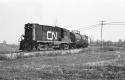 Date: 03/01/21 14:32 Re: MLW Monday - CN RS-18 Using the Ellwood Connector Author: refarkas This image is beautiful in the simplicity of its scene.
Bob Date: 03/01/21 18:59 Re: MLW Monday - CN RS-18 Using the Ellwood Connector Author: moonliter feclark Wrote:
------------------------------------------------------- > I guess with last Thursday's shot of CP coming up > to Ellwood diamond, and Gerry's post last night, I > have an idea of a direction to take some future > scanning. Not sure how it'll all time out. Anyway, > this one was already done, so it's convenient to > start here. If you aren't familiar with the area, > the TSG has a useful map. The former CP Ellwood > Sub runs NW-SE, crossing the former CN Beachburg > Sub, running NE-SW, at Ellwood Diamond. A > connector existed in the north quadrant, and from > what I can see on Google Satellite, its tracks are > still in place, badly overgrown, but the switches > have been removed. Photo 1: Map of the Area and Ellwood diamond and connecting track. Credit: Ontario Council of University Libraries collection. The map is dated 1971 so Heron Road hasn't been 4-laned or grade-separated. The connecting track was put in 1966 and became part of the Ottawa Terminal serving the new Ottawa Union Station. This was all part of the Greber Plan to remove tracks and yards from Ottawa’s core. The connection was needed to enable CP’s North Shore trains to enter the new Ottawa Station. The Ottawa Terminal was an agreement between CP & CN with CN CTC controlling the terminal. Gerry Gaugl Ottawa ON Edited 1 time(s). Last edit at 03/01/21 19:02 by moonliter. 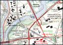 Date: 03/01/21 20:04 Re: MLW Monday - CN RS-18 Using the Ellwood Connector Author: feclark Nice work, Gerry! This is terrific stuff, and helps people get oriented.
Fred Date: 03/01/21 20:30 Re: MLW Monday - CN RS-18 Using the Ellwood Connector Author: thehighwayman Thank goodness for the map!
Seeing Carleton University listed was the only way I knew this post was about the Ottawa area. Will MacKenzie Dundas, ON Date: 03/02/21 10:44 Re: MLW Monday - CN RS-18 Using the Ellwood Connector Author: feclark thehighwayman Wrote:
------------------------------------------------------- > Thank goodness for the map! > Seeing Carleton University listed was the only way > I knew this post was about the Ottawa area. > > Whoops! I lost track of mentioning that, caught up in the idea of it being part of a series of threads. I'll edit the post; thanks. Fred |