| Home | Open Account | Help | 234 users online |
|
Member Login
Discussion
Media SharingHostingLibrarySite Info |
Eastern Railroad Discussion > Pittsburgh landmark ID help neededDate: 07/06/19 15:17 Pittsburgh landmark ID help needed Author: santafe199 What self-respecting railfan photographer doesn’t love massive chunks of RR hardware for scenery fodder? While slicing westbound through Pittsburgh last May on the Penn-Lincoln Parkway (I-376) I just couldn’t help myself. I clicked off a few in motion shots, all without any trains. Now I need some ID help for the RRs ‘running upon’ said hardware. I provided some feeble explanation alibis in my captions:
1. I believe I’ve just come westbound out of the Fort Pit Tunnel. The upper spans have “NORFOLK AND……” visible at the right hand side. So I will reasonably assume this is current NS trackage. But who & what is/was the lower line? Google Maps has me believing I’m in the burb of ‘Mt Washington’. 2. Seven minutes later, on a fairly clear highway I get this shot in the burb of ‘Carnegie’, or so says G-Maps once again. Whose current line, and what heritage does it carry? Edited 1 time(s). Last edit at 07/06/19 15:20 by santafe199. 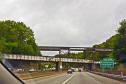 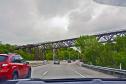 Date: 07/06/19 15:19 Re: Pittsburgh landmark ID help needed Author: santafe199 Even though 78 minutes transpired between image #2 & image #3 I’m still in the Pittsburgh area. My idiot navigator kept me plowing up I-376, when he KNEW I wanted to get north of the Ohio. After dis-entangling myself from a dangerous vortex called “Pittsburgh International Airport” I got turned back east. Then I got the bright idea to just cut through Robinson Township while searching for I-79 northbound. I’m pretty sure this is where the bulk of my expletive-deleted 78 minutes went…
3. 4. & 5. Another impressive hunk of iron came before my viewfinder. While my left hand kept firm control of Willie IV (my faithful rig) my right hand was burning pixels. By this time I was north of the Ohio, down on Beaver Avenue. So the traffic safety factor eased up several notches. I will assume this is the NS bridge over the said Ohio. But is N&W its original heritage? Instinct tells me it might have been CR/PC/PRR… Google Maps says I’m in the burb of ‘Marshall-Shadeland’ for these 3 shots. (5 photos taken from my in-motion Willie IV on May 13, 2019) TIA for the help! Lance Garrels santafe199 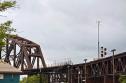 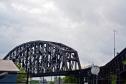 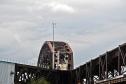 Date: 07/06/19 15:20 Re: Pittsburgh landmark ID help needed Author: JUTower Both are the current Wheeling & Lake Erie route running from Ohio to Connellsville, Pa. Originally Pittsburgh & West Virginia, later N&W then NS. Spun off by NS in around 1990.
Posted from iPhone Date: 07/06/19 15:21 Re: Pittsburgh landmark ID help needed Author: JUTower 2nd post is the Ohio Connecting Bridge. Originally PRR later Conrail now NS.
Posted from iPhone Date: 07/06/19 15:29 Re: Pittsburgh landmark ID help needed Author: santafe199 Wow! Very quick results. And a tangled, but very interesting heritage on images #1 & #2! I would never have guessed. And I was sorta close on 3-5. That bridge looks like something the "Standard Railroad of the World" would construct... :^) Thanks for the help!
Lance/199 added: Are the 3 suburb locations correct? For example, if I file image #2 as "W&LE Carnegie scene 2019-05-13b Carnegie (Pittsburgh), PA" would I be within reason? Edited 1 time(s). Last edit at 07/06/19 15:55 by santafe199. Date: 07/06/19 16:31 Re: Pittsburgh landmark ID help needed Author: toledopatch JUTower Wrote:
------------------------------------------------------- > 2nd post is the Ohio Connecting Bridge. Originally > PRR later Conrail now NS. And just to elaborate further, this is not the PRR mainline, but rather a secondary route used primarily by doublestack and coal trains; the former to bypass low clearances in downtown Pittsburgh and the latter trains coming up from the southwestern PA coalfields to go either east on the Conemaugh Line or west on the main line. Date: 07/06/19 16:45 Re: Pittsburgh landmark ID help needed Author: DJ-12 A bit more info:
1. The high bridge is the W&LE, ex N&W, originally P&WV Pittsburgh Sub at a location known as Kelly by the railroad. The lower bridge is the same railroad’s former West End Branch abandoned in the mid 2000’s. 2. Second shot is the same mainline as 1, location is west end of Rook Yard, Technically Green Tree Pa. 3. The last three at the OC Bridge at a location called Isle. (You are on Island Ave below). The tracks on the right are the Mon Line, the trck on the left is the connection down to CP Penn. You are technically still in Pittsburgh here by yes Marshall Shadeland is the neighborhood. Posted from iPhone Edited 2 time(s). Last edit at 07/06/19 16:51 by DJ-12. Date: 07/06/19 18:24 Re: Pittsburgh landmark ID help needed Author: SantaFeRuss toledopatch Wrote:
------------------------------------------------------- > JUTower Wrote: > -------------------------------------------------- > ----- > > 2nd post is the Ohio Connecting Bridge. > Originally > > PRR later Conrail now NS. > > And just to elaborate further, this is not the PRR > mainline, but rather a secondary route used > primarily by doublestack and coal trains; the > former to bypass low clearances in downtown > Pittsburgh and the latter trains coming up from > the southwestern PA coalfields to go either east > on the Conemaugh Line or west on the main line. > Heading across the Ohio Connecting bridge to the west side of it the main tracks make a left and the double track line becomes the "Mon Line" as it is called locally. The Mon line goes mostly south along the Monongahela Rive down past Brownsville, Pennsylvania and into Green County and far Southwest ,Pennsylvania coal country. As mentioned this ine also host double stack trains down to the "Port Perry" branch that crosses the Monongahela river at Duquense, PA.. The Port Perry rejoins the mainline through central Pittsburgh at CP Wing (Wilmerding, PA) just west of the Wabtec (Westinghouse Airbrake) building. SantaFeRuss Date: 07/06/19 19:17 Re: Pittsburgh landmark ID help needed Author: santafe199 Thanks everyone! This is exactly the kind of location info I was looking for!
Lance/199 Date: 07/07/19 07:53 Re: Pittsburgh landmark ID help needed Author: DJ-12 Lance, glad you enjoyed your visit. Here are a few shots of trains on the bridges you were interested in:
1. W&LE train 611 at Kelly. 2. W&LE train 212 at Rook. 3. NS OCS train on the OC bridge. 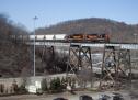 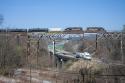  Date: 07/11/19 12:15 Re: Pittsburgh landmark ID help needed Author: santafe199 DJ-12 Wrote: > ... Here are a few shots ...
Thank you so much!! And I almost missed them. I probably would have had our good man "flynn" not posted his thread about the OC bridge on today's (7-11) Nostalgia forum. Funny how things turn out... Lance/199 |