| Home | Open Account | Help | 335 users online |
|
Member Login
Discussion
Media SharingHostingLibrarySite Info |
Eastern Railroad Discussion > New Vantage Point in Pittsburgh's South SideDate: 01/11/21 19:08 New Vantage Point in Pittsburgh's South Side Author: RuleG Last Year, a new public space opened in Pittsburgh South Side. Named "The Highline," it is an elevated space at what was once a large terminal building. The structure spans CSX's former Pittsburgh & Lake Erie line. It offers a new vantage point for photographing CSX trains.
The first photo, taken November 14, 2020, is looking south (railroad east). An eastbound intermodal has just passed under The Highline and the crossing at South 4th Street. To the left of the train is the South Side Trail which is a component of the Great Allegheny Passage Trail linking Pittsburgh with Cumberland, MD and Washington, DC. The second photo, taken November 29, 2020 is looking north (railroad west). An eastbound freight is just about to pass under The Highline. The metal structure across the top is the Liberty Bridge. In the background is Mt. Washington. (Sorry about the image being on its side. I've never encountered this problem before. Despite several attempts at correcting this, I do not know how to get the photo to display properly). Edited 1 time(s). Last edit at 01/11/21 19:17 by RuleG. 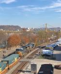 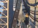 Date: 01/12/21 07:48 Re: New Vantage Point in Pittsburgh's South Side Author: march_hare Is the Allegheny Passage trail now continuous through the Pittsburgh suburbs? Last I knew there was a gap in there. I'd like to bike it next spring.
And thanks for the heads up on this vantage point. Date: 01/12/21 09:54 Re: New Vantage Point in Pittsburgh's South Side Author: OregonHoosier I have an old, old (2003) version of Microsoft Office which has a utility called Picture Manager that does the job just fine. Of course, since it is useful and functional, they have taken it out of more recent versions of Office.
 Date: 01/12/21 13:32 Re: New Vantage Point in Pittsburgh's South Side Author: RRTom What is the new public space used for?
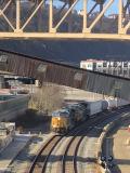
Here are some photos of the area from 1984. I walked along the P&LE ROW to this location from Station Square on family trips to Pittsburgh. 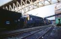 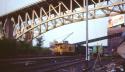 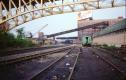 Date: 01/12/21 14:33 Re: New Vantage Point in Pittsburgh's South Side Author: Lackawanna484 Great thread! I love these threads with old billboards, old cars, old buildings, etc. These elements offer so much character to pictures of trains, cabeese, locomotives, etc.
Date: 01/12/21 19:32 Re: New Vantage Point in Pittsburgh's South Side Author: DJ-12 Nice stuff guys. For those that don't know, these buildings were a turn of the century warehouse/transfer facility that was served by the P&LE. I believe goods could be transfered between rail, truck, and barges. A series of freight elevators brought freight from the rail served facilities below up to the loading docks above. It's definitely a neat area with the Liberty bridge, the Panhandle Bridge, and the Bryan Materials conveyor bridge crossing overhead. The buildings were eventually converted to offices and it used to be a great quiet place where you could drive right in on the weekends and shoot in each direction. No one ever bothered you either so I hate to see the easy access go away, but this is a good re-use of a great historical structure. I haven't been down there since they converted it to this linear park concept. Should be fun in the summer!
1. Empty oil train from a few years ago with the 10th St bridge behind. 2. Empty hoppers for the MGA coming east under all the bridges. 3. Pre renovation with vehicular access. Edited 1 time(s). Last edit at 01/12/21 19:36 by DJ-12. 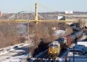 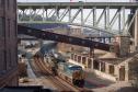 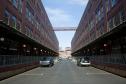 Date: 01/12/21 21:03 Re: New Vantage Point in Pittsburgh's South Side Author: RuleG march_hare Wrote:
------------------------------------------------------- > Is the Allegheny Passage trail now continuous > through the Pittsburgh suburbs? Last I knew > there was a gap in there. I'd like to bike it next > spring. > > And thanks for the heads up on this vantage > point. Yes, the trail is continuous from Pittsburgh through the Monongahela Valley communities, along the Youghiogheny River and onto Cumberland. There is also the Montour Rail Trail linking Allegheny County's western suburbs with the county's southern/southeastern suburbs. According to the website, it is the nation's longest rail-tral. The eastern end of the Montour Trail is near, but does not directly connect to the Great Allegheny Passage trail. https://montourtrail.org Edited 1 time(s). Last edit at 01/12/21 21:03 by RuleG. Date: 01/12/21 21:24 Re: New Vantage Point in Pittsburgh's South Side Author: RuleG Nice photos, DJ-12!
(Note to self: get a real camera!) Here are more photos of the public space taken in August 2020. 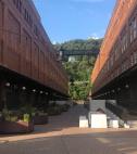 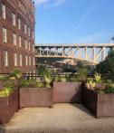 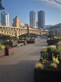 Date: 01/12/21 21:26 Re: New Vantage Point in Pittsburgh's South Side Author: RuleG OregonHoosier Wrote:
------------------------------------------------------- > I have an old, old (2003) version of Microsoft > Office which has a utility called Picture Manager > that does the job just fine. Of course, since it > is useful and functional, they have taken it out > of more recent versions of Office. Thank you, OregonHoosier! Date: 01/13/21 06:45 Re: New Vantage Point in Pittsburgh's South Side Author: DJ-12 Thanks for the pics showing the "after" look. Glad they didn't put up idiotically high fencing or anything.
Edited 1 time(s). Last edit at 01/13/21 06:46 by DJ-12. Date: 01/14/21 15:24 Re: New Vantage Point in Pittsburgh's South Side Author: jmbreitigan I appreciate the info RuleG
John |