| Home | Open Account | Help | 235 users online |
|
Member Login
Discussion
Media SharingHostingLibrarySite Info |
Western Railroad Discussion > Where are theyDate: 09/10/08 16:31 Where are they Author: BobB Here are a couple of shots a few miles apart, taken on a UP main line on a surprisingly busy Labor Day. It's not a specific location I'd been to before, and I have seen little about it on this board or elsewhere. I'm curious to see how many people are familiar with it.
  Date: 09/10/08 16:34 Re: Where are they Author: rdb3 Looks like the area near Fremont/Niles/Warm Springs (East Bay, CA)
Date: 09/10/08 17:06 Re: Where are they Author: Infern0 Somewhere near Jurupa ?
Date: 09/10/08 18:25 Re: Where are they Author: BobB So far wrong state.
Date: 09/10/08 18:35 Re: Where are they Author: trkinsptr Gibbon,Oregon CJ
Date: 09/10/08 19:44 Re: Where are they Author: trainfreek trkinsptr Wrote:
------------------------------------------------------- > Gibbon,Oregon CJ I'm guessing somewhere east of here, maybe a little closer to Durkee or Huntington? Mark Wohlgemuth Culpeper, VA Date: 09/10/08 20:03 Re: Where are they Author: BobB trkinsptr Wrote:
------------------------------------------------------- > Gibbon,Oregon CJ A winner--at least for the first picture, which shows the remnants of the yard at Gibbon, which is at the western base of the Blue Mountains some miles east of Pendleton. It includes a little-used wye (that crosses the road) for turning helpers, although all the trains I saw had DPU or nothing. The second picture is of an eastbound right before the 90 degree curve that turns the railroad into the Meacham Creek canyon and the climb to the summit at Kalama. I went there after four nights in the Eagle Cap wilderness in the Wallowa mountains--another time of combining my two favorite outdoor activities--hiking and trainwatching. Date: 09/10/08 21:03 Re: Where are they Author: trkinsptr Most fans skip the area between Gibbon and Pendleton but I think there is a lot of good photo spots there. Camp,Duncan&Huron also are good but are a lot harder to get to these days. Glad to see your getting to some places off the beaten track BobB. CJ
Date: 09/10/08 21:28 Re: Where are they Author: BobB trkinsptr Wrote:
------------------------------------------------------- > Most fans skip the area between Gibbon and > Pendleton but I think there is a lot of good photo > spots there. Camp,Duncan&Huron also are good but > are a lot harder to get to these days. Glad to see > your getting to some places off the beaten track > BobB. CJ Thanks. I found the area quite interesting as well as remote--both things I like. This leads to another question--how does one get to Duncan and the other locations? Old Meacham Creek Road seems to go there, but about a quarter mile in there's a gate (open when I was there) with a no hunting/no trespassing sign. Meacham Creek Road follows the tracks, and there's a gate (also open) with UPRR no trespassing signs. I did see one pickup go along that road. Both roads have signs of the sort that one would find identifying a public road. Also, there's a sign (reproduced below) right next to Meacham Creek Road and the UP tracks that gives fire restrictions--the kind of sign that one would expect on a road open to the public. My maps and GPS show those roads going at least to Duncan, but I obeyed the signs and stopped. Is there a legitimate way to drive or hike on one of those roads? 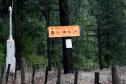 Date: 09/10/08 22:25 Re: Where are they Author: Indecline I get up that way once in a while. I've never taken the road up along the hill though. I've generally understood it might be seriously tresspassing, though I've never tested that understanding. There is getting to be a lot of vegetation along the tracks these days that makes it harder to shoot than in the 80's.
Date: 09/10/08 23:00 Re: Where are they Author: cruzatteym I rode my mountain bike last weekend down Meacham Creek road below Highbridge from Meacham. The gate at the top was closed and locked. A very nice, and apparently over worked, track foreman drove by putting up many slow orders and mentioned that UP has been ticketing for being on that road. He said the final straw was hunters shooting out signals and someone trashed a large piece of MOW equipment. This is the only access that I know of down the canyon to Huron, Bonifer, etc. Some great photo opportunities down there. Over the past number of years, I had driven the road and ran into many fisherman down there so I've always thought that there was some sort of an easement for access to the canyon (lot's of public type of signage). Parts of the canyon also lie within an Indian reservation.
Date: 09/11/08 21:26 Re: Where are they Author: trkinsptr There used to be a road between Huron& Summit road. Also beware if you go beyond the gates on the access roads they may be locked when you come back! Around Camp you cross Meacham creek( big round rocks- is there a bridge now?). Also the "road" is loose ballast right next to the tracks in many areas with steep drop offs!.Those old flat car bridges aren't in the best shape either. Be carefull! CJ
|