| Home | Open Account | Help | 326 users online |
|
Member Login
Discussion
Media SharingHostingLibrarySite Info |
Western Railroad Discussion > Info needed on BNSF line in Montana…Date: 09/01/15 13:57 Info needed on BNSF line in Montana… Author: StephenK Hello everyone. While traveling to Glacier National Park this summer I noticed a BNSF line running from Glendive, MT to Circle, MT parallel to MT 200S. Coming out of Glendive, the track seemed well maintained. In a few miles a rock/sand facility was moving cars around for loading. In about another mile or two the track condition started to deteriorate and weeds were growing on the tracks. A few miles after that the track looked like it was not passable. I noticed the signs on the crossbuck indicated that it was BNSF owned. After following the line for many miles, I noticed a lot of old, vintage trestles spanning multiple creeks. I also noticed a few grain elevators in a couple towns that looked like at one point might have been served by this line. In many ways this line appeared to have been used not too long ago. I was hoping to gather some information on this line, if anyone knew anything. The following questions were some of the things I was wondering: What was the name of this line? When was it last used? Who were previous owners? Where does the line start/end or connect to another line? Had it once connected the mainline in Glendive, to Wolf Point? If anyone knows any other information, that would also be appreciated. Thanks for helping an Eastern Railfan out!
Below is a Google map of the line. The red line represents the rail line, the yellow line is MT 200S, and the star is the Rock/Sand Facility – all markings are approximate. Thanks, StephenK Edited 1 time(s). Last edit at 09/01/15 13:58 by StephenK. 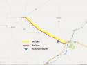 Date: 09/01/15 14:51 Re: Info needed on BNSF line in Montana… Author: monaddave That line is BNSF's Circle Subdivision. This former Northern Pacific line is 50 miles long from the minline connection at Glendive, west to Circle. It is out of service west of Fisher, MT (that sand and gravel outfit). Not sure when it was last used for revenue service, but at one time they were using it to store rail cars. Originaly, the line went as far as Brockway, 12 miles to the west of Circle, along MT 200. On google Earth, you can see the old RofW south of MT 200 to Brockway.
I think there still may be some geeps on hand at the gravel pit, for switching duties. Stations on the line are Fisher at MP 7.8; Lindsay at MP 24.4 and Circle at MP 50.0. Dave in Msla Edited 1 time(s). Last edit at 09/01/15 14:54 by monaddave. Date: 09/01/15 15:52 Re: Info needed on BNSF line in Montana… Author: terrybaker Here are some links to several recent discussions that included this branch:
pictures of Brockway depot: http://www.trainorders.com/discussion/read.php?11,3501192,3501868#msg-3501868 picture of Circle depot: http://www.trainorders.com/discussion/read.php?11,3467593,3467593#msg-3467593 general information and pix: http://www.trainorders.com/discussion/read.php?1,3465883,3466350#msg-3466350 Also, several additional shots taken in Circle 6/18/14: 1) History of the branch (hope it's legible) 2) & 3) looking east and west in downtown Circle 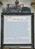 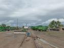 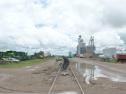 Date: 09/01/15 15:56 Re: Info needed on BNSF line in Montana… Author: terrybaker 4) & 5) On the west side of town, again looking east and west
6) A Circle survivor in country that's hard on pick-ups 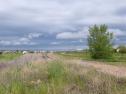 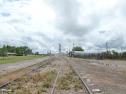 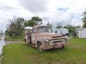 Date: 09/01/15 16:03 Re: Info needed on BNSF line in Montana… Author: MM171 The Glendive to Circle rail line was originally Northern Pacific. I believe the wood trestle right east of Circle was condemned quite some time ago. I vaguely recall BN (at that time) was growing concerned as to whether or not the trestle would support loaded grain hoppers. So....doing what railroads do best, they embargoed the spur.
I never quite understood that folly since there is a substantial amount of grain grown in those parts with a fairly large grain elevator in Circle. So....fast forward to now. A terrific amount of the area's grain gets augered onto the semi and sent west to the grain shuttle loaders in Moccasin and Moore, Montana. Progress???? Let the reader be the judge! The last time I waltzed a 53' livestock trailer down Hiway 200 from Circle and into Lewistown, Mt, I came to the conclusion there had to be another way! As for the railroads doing what they do best; why put big $$$$$$ into trestle repair when Uncle Sam will spend gas tax to repair the asphalt pounded to oblivion by the grain trucks? Another thought; The Gt Northern RR built a railroad bed east from Lewistown for close to 30 miles back in the days when railroads were building tracks to everywhere. It is discussed in some GN RR history books. I often speculated that if the steel had been put down, it would have no doubt headed east through Jordan, MT and tied into that Glendive-Circle NP line. Maybe somebody knows more on that thought. The GN roadbed east out of Lewistown is still quite visable in many places. I do not know if they built a tunnel on the Lewistown divide but the grading definitely indicated that plan. That tunnel location is on Private property so I've never went looking. There were big railroad plans for east central Montana at one time. Somebody ran outa steam! Date: 09/01/15 19:56 Re: Info needed on BNSF line in Montana… Author: billmeeker The Milwaukee Road also built east out of Lewiston, to Winnett.
Date: 09/03/15 12:26 Re: Info needed on BNSF line in Montana… Author: StephenK Thanks a lot for all of the information and pictures!
|