| Home | Open Account | Help | 366 users online |
|
Member Login
Discussion
Media SharingHostingLibrarySite Info |
Western Railroad Discussion > Cajon Summit Burn AreaDate: 08/21/16 14:58 Cajon Summit Burn Area Author: TrackMap As seen from Hwy. 138 yesterday.The area was obviously traversed with several north-south Phos Chek drops that stopped the fire line from advancing into the Summit Valley Area. These must have been very tricky (heroic) drops given the terrain and power lines. The shocking thing about seeing it firsthand is just how much vegetation burned over a short period. You can trace the old roadbed in the second photo. I was onsite there a few months ago and the brush was high enough to block one's view of the BNSF main tracks.
Gerard Highland, CA Edited 1 time(s). Last edit at 08/21/16 18:32 by TrackMap. 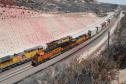 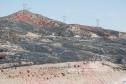 Date: 08/21/16 18:41 Re: Cajon Summit Burn Area Author: qnyla Thanks for posting the photos. Interesting to see how it looks.
Date: 08/22/16 11:37 Re: Cajon Summit Burn Area Author: toledopatch Agree. I thought the post-fire scenery would be distinctive, and it is indeed a story-teller.
Date: 08/22/16 16:18 Re: Cajon Summit Burn Area Author: jmbreitigan Now you have to wonder what will happen when the rains come.
|