| Home | Open Account | Help | 368 users online |
|
Member Login
Discussion
Media SharingHostingLibrarySite Info |
Western Railroad Discussion > Elko Flooding PicturesDate: 02/15/17 20:11 Elko Flooding Pictures Author: JDLX We got internet service restored to our house yesterday (equipment issues unrelated to the flooding), so I can finally start posting some pictures I have taken around town in the last week. First off, I want to acknowledge up front I took a lot of these with my iPhone, and as such they are not technically speaking the greatest quality photographs.
A quick review. This has been a strange winter so far, we've alternated between the more traditional Pacific frontal systems and pineapple expresses several times, usually resulting in a little bit of a snowpack developing, then a tropical storm melts it all. That happened several times, then a series of wet North Pacific storms between December and January resulted in one of the larger snowpacks we have seen in quite a few years now. Then another very warm and very wet tropical storm rolled over the region around the middle of last week, resulting in almost all of the snow pack at least in the lower elevations melting rapidly. By last Friday, the Humboldt River was in full flood stage through Elko. We'll start about mid-day last Friday, when the first crush of flood waters hit. The first picture is a little past the east end of the yard looking west, while the second and third pictures are near the east throat of the yard. Note especially the hay stacks in the second picture, the river's normal channel is beyond that, almost to the base of Elko Mountain. In the second and third pictures, the nearest track is the former SP mainline typically used for westbound trains, while the farther track is the old WP mainline typically used for eastbounds. Just past this point the WP swings across the river and its floodplain, the river ate away good parts of this fill over the weekend. To be continued. 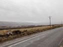 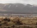 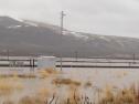 Date: 02/15/17 20:18 Re: Elko Flooding Pictures Author: JDLX For this next series we've moved down to the very east end of the yard, these give a good idea of how close to the rails the waters rose. UP crews have already set up several pumps trying to push the water coming up inside the yard back out over the WP main and towards the river, and other equipment and personnel have started to gather on the site. A westbound auto train had recently arrived, it would end up being one of the last trains into town for a little while.
I came back a couple hours later for another look. The last photo is east of town looking east, the river is normally in the line of willows cutting across the lake towards the mountain, the lake in the foreground is all irrigated hay fields. To be continued. 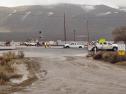 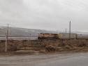 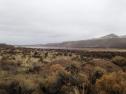 Date: 02/15/17 20:23 Re: Elko Flooding Pictures Author: JDLX Moving back to the same crossing as in the last post, the ever increasing numbers of people and equipment- and rising water levels- can easily be seen.
I then headed back over to the 12th street bridge, next to the Amtrak stations. A stack train was sitting on the main just east of the yard, with this train of eastbound hoppers at the station right behind it. At least a couple more manifest freights sat on the mainline east of town, none of these would move until at least Sunday. The third photo is looking down at the eastbound Amtrak station, the flooded road continues on parallel to the tracks to some gravel pits and other industries farther east. To be continued. 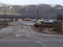 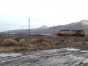 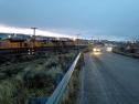 Date: 02/15/17 20:30 Re: Elko Flooding Pictures Author: JDLX The Humboldt through Elko officially hits flood stage at 8 feet. The river crested at or close to 11 feet several times between Friday night/Saturday morning and Monday before starting to slowly recede in the last couple days.
This first view is looking generally south across the river from the road down to the eastbound Amtrak station, the river channel is normally in the willows and well underneath the bridge visible to the right of the picture. A large gravel pit is under water in the foreground. The westbound Amtrak station was completely flooded, as was the entire stretch of Water Street where it runs alongside the sound wall that is built up along the tracks through town. The worst of the flooding was in the areas south of the river, a lot of the homes and businesses flooded, and that was the part of town that could least afford it. The last two photos are taken from the eastbound Amtrak platform looking across the tracks and the flooding on the north side. To be continued. 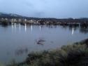 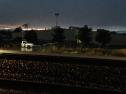 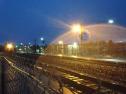 Date: 02/15/17 20:34 Re: Elko Flooding Pictures Author: JDLX Monday morning I brought my camera into town, but it was hard getting any pictures due to the rising sun. Water levels are still way up, and I caught a couple of the fleet of westbounds arriving at the yard. A large number of eastbounds are piled up in the yard and on the main waiting for the line to clear.
The return of cold temperatures caused a lot of the ponded water to freeze, which did result in some interesting ice formations. One more 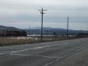 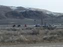 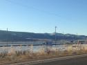 Date: 02/15/17 20:42 Re: Elko Flooding Pictures Author: JDLX Last three, one more looking west towards the east end of the yard about midday yesterday, then an eastbound unit tank train late this evening. Despite reports that both line are now open between here and Alazon, this eastbound is heading out on the westbound track, indicating there may still be problems out there someplace.
Water is still way up from normal as can be seen in the last two photos, but is has retreated from much of Elko proper. The crush of floodwater is now making its way west, and is presently somewhere in the Battle Mountain area, if not a little further west from there. And we are not out of the woods yet, as another series of warm and wet storms are projected from tomorrow through the end of the next week, which very well could cause the river to come back up again, especially if it starts melting the snowpack at the middle to upper elevations on the mountains. Thanks for looking, hopefully I don't have cause to take many more of these. Jeff Moore Elko, NV 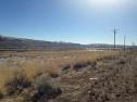 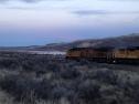 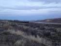 Date: 02/15/17 21:55 Re: Elko Flooding Pictures Author: mcfflyer Keep dry, Jeff!
Lee Date: 02/15/17 21:57 Re: Elko Flooding Pictures Author: ironmtn No worries on the quality of the images; they're just fine. Thanks for sharing them.
I have to admit that your headline immediately grabbed my attention. Flooding in Elko?!?!?! Really? Now that's saying something! (No disrespect to your hometown intended). I've passed through or stayed overnight several times through the years, and that such things could happen on the summertime trickle of the Humboldt through the sagebrush flats just never occurred to me. I should have known better. I know the power of rivers and floods large and small, having grown up just a few miles from the confluence of the Missouri and Mississippi above St. Louis. Totally different scale, to be sure, but all of us who hail from there know all too well how trickles can become mighty torrents -- and contribute to yet mightier ones downstream. Best of luck to your and your neighbors and fellow Elko residents. Hope you all stay safe, dry and well. Best of luck to UP as well, hoping for the safety of all who are laboring out there to keep the line in service. MC Muskegon, Michigan Edited 1 time(s). Last edit at 02/15/17 21:59 by ironmtn. Date: 02/16/17 07:19 Re: Elko Flooding Pictures Author: funnelfan Is the ex-SP east of Wells open yet?
Ted Curphey Ontario, OR Date: 02/16/17 07:29 Re: Elko Flooding Pictures Author: callum_out You don't think of Elko and water but years past a huge hillside came down over 766 on the way to both the Newmont
and Barrick digs up the Carlin Trend. The truck traffic though there was in the hundreds per day with a detour being hastily established down the Newmont hual road (give way to the haul trucks!!). The slide was due to water caused slippage. Out Date: 02/16/17 08:04 Re: Elko Flooding Pictures Author: JDLX Last report is the SP line east of Wells will be closed for several weeks. Lots of damage caused by runoff west of Montello, then that plus the dam failure and added runoff from the Thousand Springs drainage punched several large holes in the roadbed east of Montello.
One thing I was going to add, this ended up being only about the third largest recorded flood in Elko, the river went over 12 feet around 1966 and then again in the early 1980s. Would be interesting to know where it was in 1910, that year dwarfed them all... Jeff Moore Elko, NV Posted from iPhone Date: 02/16/17 08:25 Re: Elko Flooding Pictures Author: Cupolau Thanks for the updates Jeff. My son and his family live in Elko and I was planning to visit them on the 27th, coming on the CZ, which doesn't look like is going to happen.
Date: 02/16/17 14:32 Re: Elko Flooding Pictures Author: pedrop My friend Greg (UP) works in this área. It is Difficult to me to believe the desert I visited sometimes ago can be flooded like this.
Posted from Android Pedro Rezende Vespasiano MG, https://youtube.com/c/minasgeraisrailways1 |