| Home | Open Account | Help | 286 users online |
|
Member Login
Discussion
Media SharingHostingLibrarySite Info |
Western Railroad Discussion > Stege Crossing Replacement WorkDate: 06/19/17 01:32 Stege Crossing Replacement Work Author: phthithu ...
Edited 1 time(s). Last edit at 07/06/18 14:18 by phthithu. Date: 06/19/17 07:46 Re: Stege Crossing Replacement Work Author: pmack Is "Stege" in this region?
 Date: 06/19/17 08:14 Re: Stege Crossing Replacement Work Author: SN711 Stege is in Richmond, CA.
That old spur was a track to no where by the time I went by there about 35-40 years ago. It ended in the trees about 500 feet south of the switch. It's intended purpose was long by that time. Of course Hoffman Blvd still existed at that time. Hoffman Blvd occupied the exact space where the freeway is now. The two legs of the wye crossed Hoffman Blvd at grade. Traffic was a lot less back then, but Hoffman was still the main route to the Richmond-San Rafael Bridge. Never hung out there back then. Richmond has never been (in my lifetime) a good place to be. Gary Posted from iPhone Date: 06/19/17 10:08 Re: Stege Crossing Replacement Work Author: timz > That old spur was a track to no where by the time
> I went by there about 35-40 years ago. Wouldn't you guess the pictured spur was built as a replacement for the track that crossed Hoffman at grade? Don't recall how long ago that was. The industry was Staufer Chemical-- what did they do there? Date: 06/19/17 12:36 Re: Stege Crossing Replacement Work Author: MP555 Picture 3, sloppy work. The steps in the 115/136 transition rails aren't in the same crib.
Date: 06/19/17 12:49 Re: Stege Crossing Replacement Work Author: MP555 The crib is the space between the ties. When using this type of transition rail, the step in the rails should be directly across from each other; no different than if they were using compromise joints.
Date: 06/19/17 14:22 Re: Stege Crossing Replacement Work Author: SN711 I guess my memory was not what I thought. I do recall now the track disappearing through a gate, but from what I recollect that it looked unused. Perhaps the cars were so far back inside you could not easily tell ( I was a youngster back then).
I do remember in later years they had derelict looking MOW cars parked near the end of track. Gary Posted from iPhone Date: 06/19/17 19:12 Re: Stege Crossing Replacement Work Author: EtoinShrdlu Please see attached, which is by and large self-explanatory. The references to "old" and "new" leads are the tracks which went into the Stauffer chemical plant before and after the freeway. The depot at Stege was actually right next to where South 47th St crossed the main lines, not where the red balloon is.
>The industry was Staufer Chemical-- what did they do there? Make chemicals, obviously. All kinds of nasty ones at that. 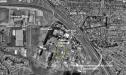 Date: 06/20/17 07:11 Re: Stege Crossing Replacement Work Author: portlander I watched the SP switch that plant in the early to mid 90's. I wish I could remember exactly when.
Date: 06/22/17 10:04 Re: Stege Crossing Replacement Work Author: EtoinShrdlu That so-called "Meade St. bypass" is the route the old lead took from the previous connection at Stege to the Seaver Ave yard. Meade St north of S 47th St, Regatta Blvd, and Seaver Ave didn't even exist before the new wye was built.
Edited to add: Please see attached google maps capture. Everything inside the red lines post-dates the freeway construction and the closure of what had been Stauffer Chemicals. Orignal connections between Stege and Seaver Ave yard/Stauffer's are indicated in yellow. Edited 1 time(s). Last edit at 06/22/17 10:44 by EtoinShrdlu. 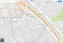 Date: 06/22/17 11:35 Re: Stege Crossing Replacement Work Author: EtoinShrdlu I need to qualify my last post slightly. Attached is a screen capture of a 1980s USGS map of the area I found in a quest to locate a horse's mouth. This shook out a few cobwebs (it has been about 35 years since I ran a switch engine in the area): what I had forgotten was that the old wye, which lead to the Seaver Ave Yd, was a separate crossing from the lead to Stauffer's. I do recall that the "connection along Meade St." was built to access Seaver Ave yard from the old connection at Stege while the wye was being rebuilt into overpasses (that yellow line in my previous post -- note that this USGS map doesn't even show Meade St in this area). This track was then re-used for accessing Stauffer's in the opposite direction, from the Seaver Ave Yd, after the old connection was severed by the freeway, with the only trackage rearrangements being the curve for entering Stauffer's. This new connection was a lot more difficult to use in the days of hand signs.
I also recall that it was dangerous and somewhat comical to cross Hoffman Blvd on either of the two crossings during morning and evening rush hours (evening, we didn't even try. What this map doesn't show is the connection to Immel's paving, which was further south (geographically) than the old connection at Stege. "Stege" on this map, BTW, is it's proper location on the SP. The UP now refers to the power crossovers south of Bayview St overpass as "Stege". Santa Fe use of the Seaver Ave lead and the SP mains to 34th Street began after the tracks through Berkeley were abandoned. The intermodal trains didn't start using it until the BNSF got access to the IMF in W Oakland. Edited to add: Forgot to mention that the RR line in purple at the bottom along the edge of the Bay mudflats is the Santa Fe's new line to Emeryville, meant to replace the line through Berkeley. It never went any further than the Post Office sorting center at the foot of Central Avenue. Edited 1 time(s). Last edit at 06/22/17 11:38 by EtoinShrdlu. 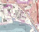 |