| Home | Open Account | Help | 334 users online |
|
Member Login
Discussion
Media SharingHostingLibrarySite Info |
Western Railroad Discussion > Photo request - tracks alongside creek/riverDate: 11/10/17 14:44 Photo request - tracks alongside creek/river Author: inCHI I'm modeling something where a track runs right alongside a creek/river and I'm considering what surface or material would be used in that case.
I've been trying to find photos of tracks that are similarly placed right next to a waterway and haven't yet found a photo. I would imagine it would be a branch line, a short line, or maybe even a logging road to have something this tight. Do anyone photos come to mind? Thanks for any help. 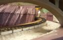 Date: 11/10/17 15:03 Re: Photo request - tracks alongside creek/river Author: donner_dude1 If you had a waterway that close to the roadbed you would have large erosion issues. All you need is one large water event and it would wipe out the trackage.
The only location that comes to mind is the area near the hanging bridge in the ex-DRGW Royal Gorge (Tennessee Pass line). Pretty tight confines but with less curvature. Date: 11/10/17 15:10 Re: Photo request - tracks alongside creek/river Author: toledopatch I would think either a stout retaining wall or very large rip-rap (boulders) would be necessary to protect such a track.
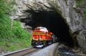
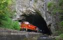
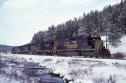
Date: 11/10/17 15:22 Re: Photo request - tracks alongside creek/river Author: Rathole There are indeed locations in which the waterway is right next to the track. Here's three photos of mine I can come up with that might cover your request. The first two were taken at Natural Tunnel, VA on 4/29/12. The third was taken on the DRGW at Tennessee Pass a while back - I didn't note the date on the scan when I made it from my slide. Hope they are of some assistance to you.
   Date: 11/10/17 15:37 Re: Photo request - tracks alongside creek/river Author: SD45X Most the pictures at Conneaut OH of the Bessemer are along the creek.
Edited 1 time(s). Last edit at 11/11/17 14:04 by SD45X. 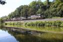 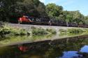 Date: 11/10/17 15:50 Re: Photo request - tracks alongside creek/river Author: icancmp193 Indian Creek runs alongside the BNSF Gateway Sub near Crescent Mills, CA, on its way to the Feather River. Depending on the rain each season, it can go from docile to lapping at the tracks. Last year, it was on both sides of the tracks more than once!
TJY 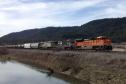 Date: 11/10/17 16:09 Re: Photo request - tracks alongside creek/river Author: inCHI Thanks for the quick responses. The Natural Tunnel shots show exactly what I was looking for. I have some brick/stone patterns that might really work in the same way as that concrete in the context of what I'm doing.
This is a model that isn't meant to be exactly accurate, and really can't be. I've got steeper grades and sharper curves that is normal, and things like water that close. But it is what makes sense for the space. It also isn't a model of a mainline, or the US, so there are is a somewhat different standard. Date: 11/10/17 18:21 Re: Photo request - tracks alongside creek/river Author: Mgoldman Raillpictures.net - it is more than just pretty pictures. Try a search using appropriate keywords.
/Mitch Posted from Android |