| Home | Open Account | Help | 392 users online |
|
Member Login
Discussion
Media SharingHostingLibrarySite Info |
Western Railroad Discussion > Questions on visit to Powder River Basin.Date: 06/21/19 11:26 Questions on visit to Powder River Basin. Author: MP4093 Since the first coal trains started rolling in the 1980's I have known of the Powder River Basin and wanted to see it if I was ever in the area. Well in a few weeks I will find myself heading north out of Cheyenne toward Gillette and the Black Hills area and noted that I would be traveling right through it. Any suggestions of places to visit where I could take some photos and get the feel for this region. I won't have a lot of time to spend and just want to capture some of the more easily available or absolutely worth it shots. I have seen coal trains almost daily for decades, I want to see where they come from. Thanks.
 Date: 06/21/19 11:48 Re: Questions on visit to Powder River Basin. Author: Lackawanna484 You will be within striking distance of the Little Big Horn battlefield, Mount Rushmore,the Crazy Horse carving, and Devil's Tower. All of which are impressive on their own.
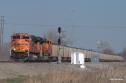
In Gillette, you can see miles of stored BNSF power in every recent scheme. Date: 06/21/19 12:22 Re: Questions on visit to Powder River Basin. Author: cozephyr From Douglas, WY take Highway 59 that goes along Wyoming Powder River Basin Coal Line. South of Wright, WY, take Highway 450 east to North Antelope Junction & the coal mines about 5-10 miles off Highway 59. Good luck 🍀
Date: 06/21/19 12:37 Re: Questions on visit to Powder River Basin. Author: map Hi Marc,
Been years since I was out there, but I would take 59 out of Douglas up through Bill. About 16 miles north of Bill is Antelope Coalmine Road. That will take you back along the tracks and around several of the coal mines. The roads seem to change names a lot. Eventually you will come out on Edwards Road (Reno Road) where you can make a left, cross over the tracks then head north on Hilight Road parallel to the railroad. You will stay next to the tracks for another 19 mile when the tracks veer away. After another 10 miles you will come to Haight Road where you can make a left and head back to Highway 59. That should give you a good sampling of the area. Mike Peters Brentwood, MO Date: 06/21/19 13:50 Re: Questions on visit to Powder River Basin. Author: Bob3985 There are a number of coal mines north of Bill. Logan Hill has an overpass near the summit southbound from the mines.
I took photos from that overpass of the 4 track mainlines some years ago. Keep in mind that coal is down about 30% so there are some fewer trains. You'll get a kick out of Bill, Wyoming. It is a Bulkk station, Crew lodging hotel and restaurant and the original two buildings of the general store and post office. Bob Krieger Cheyenne, WY Date: 06/21/19 14:39 Re: Questions on visit to Powder River Basin. Author: TCnR Agree with what's been said so far, part of the confusion is that the mines are literally moving westward towards hiway 59 so the local roads change as the area is dug out. Some of the key descriptors are south of Gillette, hiway 59, then Hilight Road and then there's new loop roads that pass a number of the mine entrances but they keep changing as well. Google is your Friend once you get into the general area. There is a huge amount of info with TO subscribers and in the past discussions on TO.
Looking at Google there's a road now called County Road 37 Antelope Coal Mine Road, I didn't know it had a name. That area has multiple tracks but not quite a 'yard', there's quite a bit of activity before and after that, some bridges and and some public land. Further north on that road there were some hills and the tracks cut around the hills, but maybe the hills are gone now, something to expect in that area. An interesting location is where the multiple tracks crest the hill south of the large mines, known as Logan Hill. There's a Rest Area on hiway 59 in that area, just north of that where the road crests the hill is Forest Service rd 942 which access a National Grassland area well past the RR tracks. The FS rd passes a number of Radio towers then crosses the tracks on a bridge, leaving a decent veiw of the tracks. It's a pretty well known area and has been fenced and posted by the RR's, but there are decent photo angles from the bridge and the edges of the cut. There's also a couple of County roads that cross the tracks further south. The WyoDOT link is also a good weather station and visual check: http://www.wyoroad.info/highway/webcameras/WYO59BelleFourche/WYO59BelleFourche.html I did drive from Cheyenne a number of times but it's a really long drive, also stayed at Gillette a couple of times. Decent national brand hotels and restauraunts there. There's also lots of action in the Glendo to Orin area along I25 and County Rd 319. There's a single track section and a stiff grade along there that causes lots of radio traffic and some decent photos. That area is still a long drive from Cheyenne though. There's also Douglas, Orin, Shawnee and Lusk areas but those are secondary to the main action just south of Douglas. In very general terms BNSF enters/exits from the Gillette area to the east and the UPRR acesses from their tracks to the south and east. But the BNSF also accesses from the south through Glendo and Guernsey. In between, near SR59 south of Gillette you'll see three or four main tracks, trains passing each other, trains following each other, every combination. It is really something to see. In the summer it's really hot and the winter it's really cold. Good idea to keep your gas tank above a half tank as there's not much out there. The RR and the Mine Owners are very concerned with safety and trespassers who have caused problems in the past, so be very careful where you are. I have some photos on my PBase site but there's an overwhelming number to be added someday. https://pbase.com/clivew/prb_coal_trains Date: 06/21/19 16:04 Re: Questions on visit to Powder River Basin. Author: bmarti7 All good above. I would add take 59 north of Gillette about 7 miles. It takes you right through Eagle Butte Mine. There’s a lookout along the highway. As you leave to head for the Hills, suggest taking Hwy 51 east to Moorcroft. It passes Donkey Creek yard and parallels BNSF east. You can jump on I-90 at Moorcroft.
BB Date: 06/21/19 16:47 Re: Questions on visit to Powder River Basin. Author: DKay Does the Ponderosa Ranch still offer rail fans accomodation on crawford hill.It is a great place to stay and watch the action.
Regards,DK Date: 06/22/19 08:10 Re: Questions on visit to Powder River Basin. Author: ntharalson Marc, get a Wyoming DeLorme atlas. As stated, Wyoming 59 more or less parallels the trackage. The last time I was out there, roads were poorly marked. However,
when you get north of Bill, the big UP staging point on WY59, you will cross over the tracks. Later, when you come upon some hills with communication towers on them, look for a right turn. This should be Steckly Road which will lead you to the top of Logan Hill, a one per cent grade trains crawl up, often with helpers added to the DPU's. After Steckly Road, watch for a country road, F39 I think, CRS, that will lead you to the Antelope Mine and Converse Junctions as well as the Antelope Creek Bridge. We can talk more about this in Pueblo. Nick Tharalson, Marion, IA Edited 1 time(s). Last edit at 06/23/19 12:50 by ntharalson. Date: 06/22/19 10:09 Re: Questions on visit to Powder River Basin. Author: TCnR Yep, agree. That's the Forest service road with the radio towers and then the County Road, just past the Rest Area. Also agree with De Lorme map book, mine has all sorts of notations. I also used Altamont Press Timetable and a similar format RR hobby map book that has been posted before but I forget the name right now, based in Seattle iirc. De Lorme was very usefule, but remember the roads change a lot.
ntharalson Wrote: ------------------------------------------------------- ... > Later, when you come upon some hills with > communication towers on them, > look for a right turn. This should be Steckly > Road which will lead you to the top of Logan Hill, > a one per cent grade trains crawl up, often with > helpers added to the DPU's. > After Steckly Road, watch for a country road, F39 > I think, CRS, that will lead you to the Antelope > Mine and Converse Junctions as well as the > Antelope Creek Bridge. > We care talk more about this in Pueblo. > > Nick Tharalson, > Marion, IA Date: 06/27/19 08:16 Re: Questions on visit to Powder River Basin. Author: MP4093 OK I'm back. Thanks to all for the info. It seems after reading and comparing to maps and satellite images that a trip up through the coal fields should be pretty straight forward railfan rules. Stay on the main roads, get fuel, have navigation tools, bring a buddy, take water and supplies, watch for trains, take photos, stay safe. Yes we are headed to the Black Hills area, it is the reason we are going, I just noted that the coal fields were on the way and wanted to see it. And Nick, we will talk in Pueblo.
|