| Home | Open Account | Help | 320 users online |
|
Member Login
Discussion
Media SharingHostingLibrarySite Info |
Western Railroad Discussion > Lake Shasta Tunnel(s)Date: 09/30/21 10:04 Lake Shasta Tunnel(s) Author: FishinJeeper Good morning everyone. I have to go to Dunsmuir this weekend. Since the lake levels are so low, you should be able to access the old tunnels that were abandoned when Lake Shasta was made. I was wonder if anyone knew how to access these tunnels, or has a pre-Lake Shasta map that shows the old right of way. Thank you for your time.
Andrew Posted from Android Edited 1 time(s). Last edit at 09/30/21 10:05 by FishinJeeper. Date: 09/30/21 10:54 Re: Lake Shasta Tunnel(s) Author: funnelfan I believe most people access them by boat. The amount of silt down there would make it hazardous to walk into them.
Ted Curphey Ontario, OR Date: 09/30/21 11:00 Re: Lake Shasta Tunnel(s) Author: dan people were boating in them
Date: 09/30/21 11:33 Re: Lake Shasta Tunnel(s) Author: callum_out There's a YT video of a guy going thru the tunnel on a kayak.
Out Date: 09/30/21 11:36 Re: Lake Shasta Tunnel(s) Author: danstar8 Search YouTube for....Jetski through a tunnel at Lake Shasta,
Very interesting Dan Date: 09/30/21 11:38 Re: Lake Shasta Tunnel(s) Author: 462pacific Here are a few samples of what to expect. These were taken in 2017 the last time the lake was so low.
They were taken just south of the Lakehead bridge and I walked in from Lakeshore Drive. 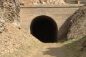 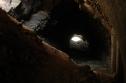 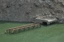 Date: 09/30/21 11:38 Re: Lake Shasta Tunnel(s) Author: Mccloud-36 Just look at Active Norcal Facebook. You can also see how low Lake Oroville is. There are pictures of the old tunnel and bridges here with video.
Posted from Android Date: 09/30/21 12:38 Re: Lake Shasta Tunnel(s) Author: Railbaron I believe the tunnel above that is shown above water has since caved in even more making it impossible to get through the tunnel; I believe I saw somebody recording it on a YT video. All the other tunnels between the above tunnel and the dam are only accessible via boat.
Date: 09/30/21 14:28 Re: Lake Shasta Tunnel(s) Author: Graybeard1942 https://www.redding.com/picture-gallery/news/2021/09/28/photos-astonishing-images-barren-lake-shasta-during-2021-drought/5807227001/
Lots of images, including some of the old Espee infrastructure. Edited 1 time(s). Last edit at 09/30/21 14:29 by Graybeard1942. Date: 09/30/21 15:34 Re: Lake Shasta Tunnel(s) Author: TCnR Must be a way to drive to the tunnel shown in the photo since there was a USFS LE truck parked there two weeks ago. The bridge tunnel combo was about half way up the metal work, was wanting to check it out next week. One of the YT video's is quite informative, it would have a very recent date. The two small water from the sky events last month put some water back into the river but it's long since past, it looks pretty skinny again.
Date: 09/30/21 18:03 Re: Lake Shasta Tunnel(s) Author: masterphots Is Shasta still generating electricity? Doesn't look like nearly enough water to to so.
Date: 09/30/21 22:43 Re: Lake Shasta Tunnel(s) Author: TCnR Below Redding the river looks about the same all year, most of that goes into farmland and diversions, etc. Not sure how to find out what the generating station is doing, there is water at the dam. It's a pretty big system not just the upper Sacramento.
+ quick search on Google explaining the system and the concerns: https://www.usbr.gov/mp/nepa/includes/documentShow.php?Doc_ID=22603 https://www.powermag.com/hydropower-levels-under-careful-watch-as-drought-ravages-the-west/ Edited 1 time(s). Last edit at 09/30/21 22:52 by TCnR. Date: 09/30/21 23:08 Re: Lake Shasta Tunnel(s) Author: TCnR So the how-to-access question is drive west from Lakehead exit. After passing the commercial campgrounds and then the USFS compound the road goes under the RR. From there the views are pretty obvious as to where the RR is and the Lake had been. The most commonly seen tunnel is roughly near the present RR bridge, careful about fast moving road traffic and be very aware of the very steep drop from the roadside.
After another mile or so there's a marina and a small restauraunt visible, a little bit after that there's a very large clearing along the lakeshore with a single entrance to the area marked with a USFS Day use Pay here sign, also a no charge today sign next to it. Take a good look for the slope and confirm the area before just driving down the road, but there's usually other RV's and such down there. The very large area is all too obvious once you get through the trees, the river is down a very steep bluff and you should see the brdige and tunnel combination from the edge of the area, suggest turning east and drive down the gully and back up then turn to the edge, there's some old fire rings right there. It's red clay and rock on the near side and grey granite on the far side. If you miss the little driveway through the trees there are no other similar areas further down the road, the road is very windy and there's no structures past the clearing. Sorry for the rough directions, I just found it a month ago. No idea how many times I drove right past it in the last 40 years. |