| Home | Open Account | Help | 375 users online |
|
Member Login
Discussion
Media SharingHostingLibrarySite Info |
Western Railroad Discussion > Lake Shasta and that old Bridge across the river - Far Nor CalDate: 10/22/21 21:47 Lake Shasta and that old Bridge across the river - Far Nor Cal Author: TCnR Had a chance to check out the abandoned Tunnel / Bridge Combo that is usually deep under the waters of Lake Shasta. The three photos give an idea of the condition of the bridge and the general reason for the tunnel, it cuts through a short steep ridge where the Sacramento River makes a number of dramatic tight bends possibly due to the type of rock it went around, as shown in the backdrop of the photos.
The route seems to have gone through the foreground ridge, then followed the right side of the river bend and then tunneled through the next ridge, then down river to Kennett and Redding in the general area between the distant hills. Around 1940 the Shasta Dam project resulted in the building of a number of tall and long bridges that bypassed this area, causing the RR to enter Redding from the north rather than alng th eSacramento River. There's many photos of the large bridges in other posts. The first photo shows where the highest Lake level would be, that's the green vegatation at the very top of the photo, also seen in #3. The funky parallel lines across the rock face is caused by the wave action of the many various lake levels through the recent years, also note the ground up rock becoming finer closer to the river and how it's sliding due to the faster river in recent days. While I was there this afternoon there was a constant stream of one or two cars driving into the area, a short distance from the town of Lakehead on Interstate 5. Just folks driving into the open area, then walking up to the edge of the very steep slope and checking out the old bridge, then going on their way. The old bridge, two tunnels and a stretch of the earlier hiway 99 roadway has been featured in a number of recent local news articles and even on YouTube, which has supplied quite a bit of background info. I have to say I've driven passed this a million times and just found it about 2 months ago. I've been digging through old maps and working with the Shasta Division Archives in Dunsmuir, also a well known retired USFS Employee to find some tunnel numbers and mileposts. #1 shows the original alignment and what appears to be a replacement Harriman era through truss bridge of the 1900's design, similar to many in the Sacramento River Canyon. When Harriman gained control of the Southern Pacific a large number of bridges were replaced and many miles of slight adjustments made to the original route. #2 shows the bridge to be a skewed design, also the cross members in decent shape but the approach has been removed or simply undercut by the river. #3 a general view with the river flowing to the right, then it makes a dramatic almost 360 degree bend off camera, the canyon can be seen behind the first ridge and then scoured hillside showing as the characteristic orange clay contrasting with the grey granite, there's at least a 180 degree river bend back there, then another 180 degree bend, then down river between the distant hills. Thanks for looking. Edited 2 time(s). Last edit at 10/22/21 22:09 by TCnR. 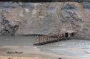 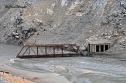 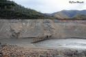 Date: 10/22/21 21:54 Re: Lake Shasta and that old Bridge across the river - Far Nor Ca Author: atsf121 Great photos. Since the bridge doesn't float, I guess they decided to leave it in place. Guess it didn't have any scrap value.
Nathan Date: 10/22/21 22:12 Re: Lake Shasta and that old Bridge across the river - Far Nor Ca Author: webmaster When they built the lake did they take out the trees and brush before filling the lake? Did the railroad leave anything else behind besides the bridges? I assume they salvaged the signals and code lines along with the rail and ties.
Todd Clark Canyon Country, CA Trainorders.com Date: 10/22/21 22:22 Re: Lake Shasta and that old Bridge across the river - Far Nor Ca Author: Mr-Beechcroft Filling up with burnt trees and debris soon.
Adam Date: 10/22/21 22:25 Re: Lake Shasta and that old Bridge across the river - Far Nor Ca Author: TCnR From what I've read and talking with some locals the project was wrapped up as fast as they could. They pulled out what they were able to relative to difficulty and the rate of the rising waters, also considering WWII was still going and labor would have been an issue. Kinda how they did things back then. I've also heard that some things were salvaged in later low water years, but the first couple of years they were more concerned with filling the dam. Recently some of the tunnels have been filled in, or maybe collapsed, I haven't found a single source of continuous info. Because of the war there wasn't a lot of documentation, in some ways the Dam would have been a major target had things gone wrong. There are some collection of photos and some documentation, people kinda forget about stuff like this.
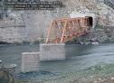
The lower lake area also had some major pollution from the smelter and heavy metal mining in the area. The Kennett smelter is said to have killed off vegetation for many miles south past Redding. Happen to have had this webpage for some info: https://en.wikipedia.org/wiki/Kennett,_California + Those bridges were built from standard parts, they were assembled by putting together the large pieces on location. To take it apart they would have had to support it and then separate each piece and then transport it out. The old hiway 99 crossing was about a mile away so it would have been possible and could have been used to repair other nearby bridges, of course they could have used the old tracks in some coordinated fashion. It was probably bought by the Government as part of the re-alignment, so maybe the RR just left it there. I'm told some smaller bridges downriver were salvaged, don't know by who though. ++ oops, the word about trees and vegatation is basically no, they probably burned off some of the vegatation but did not make a concerted effort to remove everything. The explanation was expediency to just fill it up and move on to other projects. That approach does cause problems with debris getting into places like the electrical generating water passages and clogging those kind of things, but that's how they did it back then. There is some info in USFS material and the local newspapers to go with. Edited 2 time(s). Last edit at 10/23/21 10:55 by TCnR. Date: 10/22/21 23:25 Re: Lake Shasta and that old Bridge across the river - Far Nor Ca Author: Evan_Werkema Thanks for the photos - been wondering if the old bridge was completely out of the lake by now. Looks like it won't be too many years before the amount of bridge visible during droughts will be dictated by mud level rather than water level. The Ed Graham shot below from 1977, the last time the lake level dropped this low, shows among other things how much silting has occurred in the last 44 years. Photo courtesy the Western Railway Museum Archives.
 Date: 10/23/21 06:50 Re: Lake Shasta and that old Bridge across the river - Far Nor Ca Author: BAB Todd dont know how they did it there but at Grand Coulee in WA state they used cat with a long cable attached to it and a huge steel ball they would drag along the what soon would be the shore to remove smaller items. They at one time were stored about 10m away from Grand Coulee. Thats the best I can do. So the great panic about that lake has occured before to greater extent.
Date: 10/23/21 07:39 Re: Lake Shasta and that old Bridge across the river - Far Nor Ca Author: wp1801 Very interesting!
Date: 10/23/21 09:01 Re: Lake Shasta and that old Bridge across the river - Far Nor Ca Author: TCnR So the piers in the 1977 photo suggest that there were some spans removed or perhaps salvaged, It would be easy to see those spans as being steel plate, easily removed.
Interesting to see the date on the photo as I was already camping and driving past this area. Also remember the sight of the missing Lake while driving over the Pit River bridge during those drought years. Date: 10/23/21 13:20 Re: Lake Shasta and that old Bridge across the river - Far Nor Ca Author: Goatboat TCnR Wrote:
------------------------------------------------------- > The lower lake area also had some major pollution > from the smelter and heavy metal mining in the > area. The Kennett smelter is said to have killed > off vegetation for many miles south past Redding. The lower Sacramento River Canyon and environs used to be very defoliated due to the smelter emissions. Watch the diesel version of SP's "This is my Railroad," and compare what the hillsides looked like in the early 50's with what they look like now. Date: 10/23/21 17:41 Re: Lake Shasta and that old Bridge across the river - Far Nor Ca Author: webmaster Thank you for the info. Interesting how much silt builds up over time reducing capacity.
Todd Clark Canyon Country, CA Trainorders.com Date: 10/24/21 10:47 Re: Lake Shasta and that old Bridge across the river - Far Nor Ca Author: TCnR Checking through some info this appears to be tunnel 5, tunnel 4 would be the one alluded to in the background ridge. Signor's Shasta Division book shows the location of Elmore, indicated as being downstream of the tunnels, as being milepost 284 before being unlisted due to the Lake Shasta diversion.
Between these tunnels and Lakehead was tunnel 6, often referred to as the collapsed tunnel. It's located in the bluff under the existing large RR bridge and is easily spotted. Signor lists the location of Pollack at MP 287.6 and then Antler at MP 290.5. Antler's is also known at the town of Lakehead on I-5, the old line and new line meet a few miles north of of Lakehead at the present location of Delta. The YouTube Videomaker seems to have some good info on this part of the Canyon and the old hiway 99 route, Signor has info on the towns and RR locations that are no longer there. The RR followed the river but the hiway followed Salt Creek to the east, there is a major roadway cut and concrete structure at that location. Date: 10/24/21 13:22 Re: Lake Shasta and that old Bridge across the river - Far Nor Ca Author: Rick2582 Third crossing of Sac River is indeed a skewed Phoenix truss as shown in the pics. Reusing a skewed truss is a bit of a challenge to find a similar location with same skew so might be why it was left.
On the other hand, scrapping it our for war material would have been dead easy, but they didn't get to it for some reason. Approaches to the third crossing were deck girder spans. Nice to see the piers out of the water in 1977, love that stone work. Hiked the RR grade down to there in August 1977 but didn't have a camera with. Tunnel 6 upstream has now collapsed a bit inside, it was wide open in 1977. There's a nice stone arch culvert at Doney Creek and stone arch culvert at a small stream just upriver from Doney Creek. East end of Pollock siding is visible (or was last week) with some siding ties and semaphore base. And the Hiway 99 bridge at Pollock has the east abutment undermined, it has settled a few feet. The east road approach washed away several years ago. |